As winter releases its grip on the alpine stretches of Glacier National Park’s famed Going-to-the-Sun Road, another lesser-known lowland route offers hiking and cycling opportunities for springtime explorers, as well as a backstory that’s rich in history.
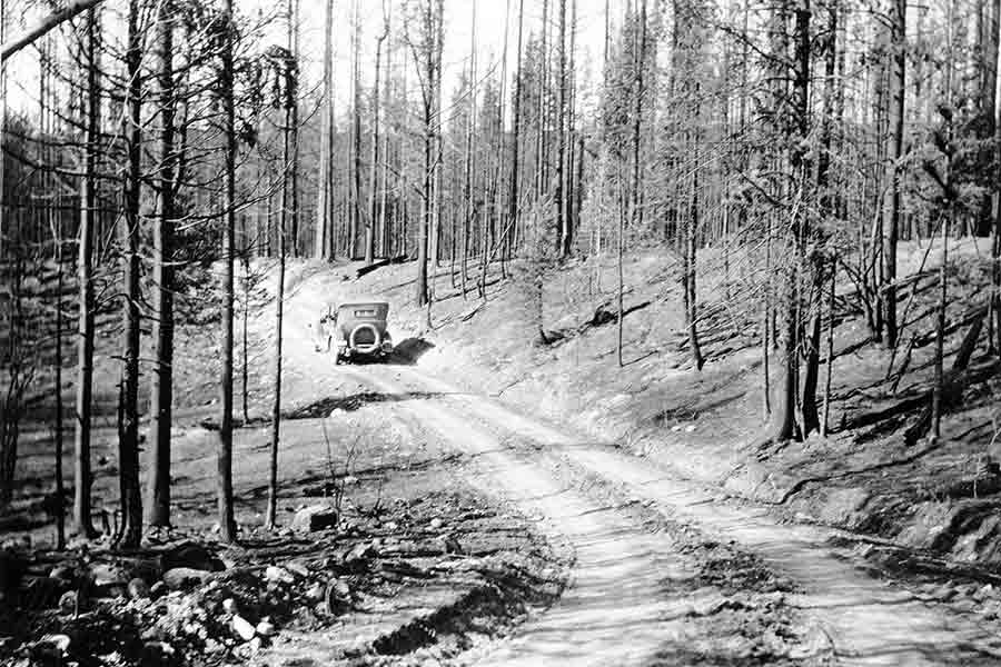
Paralleling the Camas Road is the often-bypassed Inside North Fork Road, a rugged route that extends from Apgar to Polebridge and nearly to the Canadian border. Built in 1901 and standing out as the oldest road in the park, the Inside Road bumps and bends through historic burn areas, wetlands and aspen groves to Logging, Bowman and, finally, Kintla lakes.
Creation of the Flathead River Road, such as it was called in the early days, marked a new district of the Glacier area opened to travel, if only by primitive and seasonal means, primarily horseback and wagon. Construction of the road was prompted by potential mineral deposits that oil developers believed held a significant pool of crude at the head of Lower Kintla Lake, enough so to merit drilling a test well.
Copper magnate Marcus Daly sponsored an exploration expedition to the northern regions in the mid-1880s, which was led by Patrick Walsh, father of eventual North Fork homesteader Johnnie Walsh. The men were directed to lay claim to such coal reserves as may be found, and a road into the North Fork became necessary to convey the heavy drilling equipment from the Belton station of the Great Northern Railway to the well site.
By 1905 the speculative oil ventures proved unproductive, but the establishment of the Inside North Fork Road would aid venturesome subsistence farmers and homesteaders as the valley was opened to legal homesteading in 1906, providing access to a rarefied region inside the boundary of what would become Glacier National Park.
Loggers and trappers followed, and were often responsible for road construction, maintenance and repair, even after the creation of Glacier National Park in 1910, when superintendents found themselves unable to respond to settlers’ demands for improved access.
“Despite local efforts, the ‘road’ barely deserved the title,” according to an administrative history of the road by the National Park Service. “At Anaconda Hill, it ‘just came straight up the hill and then straight down.’”
Heavily loaded cars and wagons were winched down by cable, and between 1918 and 1940, despite seasonal repairs, the park superintendents repeated various claims that the road was “practically impossible for automobiles to get over.”
Today, the roads inside Glacier National Park’s North Fork country are still maintained in a primitive condition — rough, dusty and narrow, with blind curves and few pullouts. The maximum posted speed is 20 mph. Long trailers or large RVs are discouraged from using the roads.
For the past decade, annual flooding has caused significant and recurring damage to the Inside North Fork Road, particularly near Anaconda Creek and Logging Creek. Another area of the road, near the North Fork Flathead River and Logging Creek, known as Lover’s Leap, is also an area of concern.
The park has brought in materials to mend damaged areas over the past several years. According to officials, these fixes have been short-lived and resulted in deposition of road base and sediment into waterways, raising concern for fisheries and the health of riparian communities.
In 2014, the park contracted an engineering firm to analyze options for road repairs at Anaconda and Logging Creeks, and Lover’s Leap. Cost estimates for these three repairs ranged from $682,000 to $735,000.
The park’s general management plan calls for preservation of the area’s wild character, with provision of only rustic visitor facilities. The road provides access to four primitive auto campgrounds and several trailheads. These few developments are surrounded by recommended wilderness.
Given the repairs needed, associated costs, and ongoing maintenance requirements and resource concerns, the park is considering the overall future of the inside North Fork Road. An environmental assessment is being prepared for the management of the road.
Objectives include developing a sustainable approach for maintenance and repair of the road, improving natural stream function in riparian areas, reducing adverse impacts on fisheries, and continuing to provide recreation opportunities in the North Fork area of the park.
But the road remains a beloved thoroughfare for adventure-seeking cyclists and hikers who strike out on their own accord.
While the Going-to-the-Sun Road offers bicyclists a pristine wilderness experience before the highway opens for the season, it’s closed to riders between 11 a.m. and 4 p.m. during the summer months, when the Inside Road remains prime territory for cyclists even during the busy months.
Cycling the 28 miles between Apgar and Polebridge offers different and unique vantage points of Glacier National Park, and in the spring, there are abundant opportunities to view wildlife. Always check with the Apgar Ranger Station for road conditions and closures prior to taking this route.