
Page 112 - Flathead Living // Fall 2016
P. 112
Outdoors
A FEW GREAT FALL HIKES
Mileage is round trip
MOUNT AENEAS / PICNIC LAKES LOOP
6 miles
2,000 feet cumulative elevation gain
Mount Aeneas is one of the most pop- ular destinations for hikers (and moun- tain goats) because you can reach a mountaintop in 2.8 miles, climbing 1,778 vertical feet to reach the 7,528-foot summit. You can take either the Camp Misery Trail or the old microwave tower access road from the parking lot. The Camp Misery Trailhead is slightly shorter, but the old road is a gentler grade and has impressive valley and mountain views. For the less experi- enced, the 1.5-mile trek to the micro- wave building and the ridge might be a good goal with its beautiful views down to Jewel Basin and Picnic Lakes framed by layers of surrounding mountain ranges. To reach Mount Aeneas, con- tinue on the remaining mile that strad- dles a rolling ridge where mountain
goats (who have the right-of-way) can often be found. For those who are con- ditioned and experienced, a trip over to the backside of Mount Aeneas to Picnic Lakes is a great loop option. After you have enjoyed the views and a break at the summit, continue southward and head left down the ridgeline on a steeper, rocky section until you spot a side hill trail, also on your left, that leads to Picnic Lakes. Follow the south shore of the second lake, where you will cross a little footbridge and head up another side hill to return over the Picnic Lake notch and down the Camp Misery Trail to the parking lot.
THREE LAKES – BIRCH, IN-THLAM-KEH AND CRATER 12 miles
1,700 feet cumulative vertical gain
Birch Lake is another favorite, so expect more hikers on the rst portion of this hike. From the parking lot, you will take Trail #7 at a junction where four trails intersect. This next section of
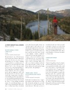
Above Crater Lake.
trail ducks in and out of the trees until you begin to traverse across the steep slope above the Birch Creek drainage. Cross Birch Creek at Birch Lake to con- tinue past In-Thlam-Keh Lake, where usage dwindles for the next few miles to Crater Lake.
TONGUE MOUNTAIN
7 miles
1,700 feet elevation gain
Take the Camp Misery Trail for .6 miles and then head north on Trail #8 to a scenic point that side hills on the south side of the draw to reach Twin Lakes notch and the trail to Tongue Moun- tain, which lies at 7,542 feet. This sec- tion of the trail begins as a gentle side hill that turns into a pleasant ridge walk. This lesser-traveled route o ers a more moderate hike with the bene- ts of views of the emerald Twin Lakes and surrounding mountains. You can also hike to Tongue Mountain from the Hungry Horse Reservoir side by taking the Jct. Graves Creek Trail.
110 FLATHEAD LIVING S FALL 2016
