
Page 114 - Flathead Living // Fall 2016
P. 114
Outdoors
THE BACK DOOR
Trails Less Traveled - Alternative Trailheads
Access from the Hungry Horse Reser- voir side of Jewel Basin is a great way to see another dimension of the land- scape and to discover the wild side of Jewel Basin. Turn o U.S. Highway 2 and cross the dam continuing on Westside Reservoir Road to reach sev- eral di erent trailheads that lead to Jewel Basin: Clayton Creek Trail #420, Wheeler Creek Trail #64, Flossy Creek Trail #49 and Pioneer Ridge Trail #71. Check with the ranger station for road and trail conditions.
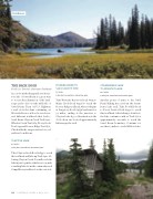
CLAYTON LAKE
4.6 miles
1,600 feet cumulative elevation gain
Take Clayton Creek Road #1633 to reach the trailhead and hike up Trail #420 fol- lowing Clayton Creek. You will reach the lake in just 2.3 miles, which is a 12.4-mile roundtrip hike from the commonly used Camp Misery trailhead on the east side.
PIONEER RIDGE TO
OLD LOOKOUT SITE
7.5 miles
1,600 feet cumulative elevation gain
Take Westside Reservoir Road #895 to Mazie Creek Road #5326 to reach the Pioneer Ridge trailhead, where it begins at Purgatory Road #9796 and runs for 7.5 miles, ending at the junction to Clayton Lake. A good destination is the old lookout site located approximately halfway up the trail.
Clayton Lake.
STRAWBERRY LAKE
TO WILDCAT LAKE
10.6 miles
2,000 feet cumulative elevation gain
Another point of entry to the Jewel Basin Hiking Area is from the Straw- berry Lake trail. Take Foothills Road to Forest Service Road #5390 to reach this trailhead. After hiking 2.8 miles to the lake, continue south on Trail #7 for approximately one mile to reach the Jewel Basin boundary. Continue for another 1.5 miles to reach Wildcat Lake.
112 FLATHEAD LIVING S FALL 2016
Jewel outhouse
