Waterways are running high in Flathead County, with some of the major rivers predicted to hit flood stage this week. And with future water levels dependent on snowmelt and weather, officials are unsure when the rivers and streams will reach their seasonal peaks.
According to the National Weather Service, the main stem of the Flathead River near Columbia Falls is expected to reach and exceed its 14-foot flood stage this week as the North and Middle forks contribute to the flow.
Ray Nickless of NWS said the Flathead River has yet to really react to the snowmelt, but this week could be a different story.
“It looks like it’s going to start taking off,” he said.
With rain systems and warm weather expected to hit the Flathead and Glacier National Park this week, river and stream levels will likely increase.
The main stem of the Flathead River at Columbia Falls is predicted to reach over 15 feet before Memorial Day weekend. The Middle Fork at West Glacier is also expected to reach its flood stage at 10 feet.
NWS removed the flood warning for the Stillwater River, Nickless said, though it is still running high.
Last week, Gov. Brian Schweitzer and officials from various state departments came to Kalispell to discuss flooding so far in the Flathead and the potential for even bigger water.
At the meeting, Marty Whitmore, NWS meteorologist, said stream flows in the Flathead were mostly normal, but there are high levels of water waiting to melt in the mountains.
“We’re starting to lose some of our lower elevation snow,” Whitmore said, noting that Northwest Montana has six sites with record-setting precipitation levels.
The snow water equivalent – meaning the amount of water trapped in the snow – is extremely high in some places. For example, Noisy Basin in the Swan Range still had 80 inches of snow water equivalent last week.
That higher elevation snow is just beginning to melt, Whitmore said, and its progress will depend on the weather. Warmer temperatures would speed up the process, but cooler temperatures at night could help slow the flow.
Still, Whitmore said the streams and creeks flowing from the mountains are expected to swell.
“We’re really concerned about some of these small streams coming out of the Missions and the Swan,” Whitmore said.
Lower-lying areas in the Flathead have already flooded, especially around Ashley Creek and the Stillwater River. The Stillwater hit 8.4 feet last week before beginning to recede; flood stage is 7.5 feet.
Residences in Evergreen had water from the Stillwater in their yards and up to their foundations last week, and crews from the county and local fire department worked to mitigate some of the flooding by removing a logjam nearby.
NWS noted that the Stillwater is a slow-moving river, so the high levels were a result of the warmer temperatures from the previous weekend. Whitmore said the long-term forecast for the Stillwater predicted levels between 8.4 and 8.8 feet, but it is all weather dependent.
“We don’t know if this is truly the seasonal peak,” Whitmore said.
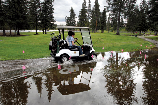
The Stillwater’s levels wreaked havoc on the low-lying holes at Buffalo Hill Golf Club last week, where grounds crews scrambled to pump groundwater off the course while remaining watchful of the encroaching river.
Huge sandbags lining the course kept the river at bay, but rising groundwater levels created new ponds and water hazards for golfers.
The river flow pulled at the banks near the cart path, leaving a hole looking like a big bite taken out of the asphalt at one area. Caddies and employees helped direct cart traffic through flooded paths and waded into puddles to retrieve golf balls.
“We’re just doing our best to keep it open,” said golf pro Marlin Hanson.
The river briefly breached the course last week, Hanson said, but the main concern is mitigating the groundwater.
“We’re just taking the punches the best we can,” he said.
At the governor’s briefing last week, Mary Sexton of the Department of Natural Resources and Conservation said the Flathead’s snow water equivalent is much higher than average.
In fact, every site providing snow water equivalent data showed more than 130 percent of average.
“These are off the charts,” Sexton said. “Not only here, but statewide.”
On the eastern side of the state, a slow-moving storm dumped as much as six inches of rain over the weekend, causing flood warnings and actual flooding in most areas. Some residents in a community near Billings voluntarily evacuated their homes, according to the Associated Press, and floodwater caused closures on Interstate 90, cutting off Lodge Grass.
Meteorologists said the floods in the east were a rain event, and the high-elevation snowpack has yet to contribute to the waterway levels.
Visit www.wrh.noaa.gov/mso/hydrology/composites.php to see the most recent river level recordings.