Essex Residents Prepare for Possible Evacuation as Wildfire Approaches
Over 200 structures in the area are at risk, according to fire managers
By Justin Franz & Dillon Tabish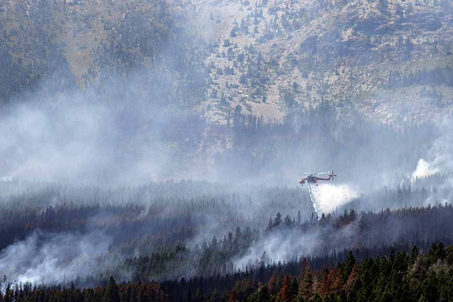
Updated Aug. 19, 8:45 p.m.
As numerous wildfires burn throughout the region and smoke blankets the Flathead Valley, the Flathead County Sheriff’s Office has issued a pre-evacuation notice to the residents of Essex and the surrounding community as the Sheep Fire continues to burn actively in a rugged section of the Great Bear Wilderness.
Officials say the fire jumped a retardant line and firefighters were pulled off the front lines of the blaze for safety.
Over 200 structures in the area are at risk, according to fire managers. A Red Flag Warning will be in effect Thursday from 9 a.m. to 9 p.m. because of low humidity and high winds.
Portions of the U.S. Highway 2 corridor around Essex moved into the ‘Set’ stage of the “Ready, Set, Go” evacuation strategy, according to fire officials. Residents of Essex and surrounding area are advised to prepare their property and themselves because of the proximity of the fire. Authorities are informing residents of the potential for evacuation. It is recommended that affected people load critical property and needs into their car, fire officials say. For more information, call 406-387-4854.
The fire, which is part of the Thompson-Divide Complex and is one of many large wildfires burning in the region, has consumed 93 acres and is burning 2.5 miles south of Essex in a steep, mountainous part of the Flathead National Forest.
BNSF Railway is also preparing in case the Sheep Fire makes a run toward Essex, according to spokesperson Matt Jones. On Wednesday, the railroad was positioning specialize water cars in Essex to help protect a snow shed and bridge that are potentially in the fire’s path. Jones said the railroad is hiring contract firefighters to help protect their assets but are also ready to help battle the blaze any way they can.
Health officials are warning residents that air quality is rapidly deteriorating across Western Montana due to wildfire smoke. An “Air Quality Alert” has been issued until 9 a.m., Thursday. State and local health officials recommend that people with respiratory or heart disease, the elderly and children should limit prolonged exertion.
Click here to view up-to-date air quality conditions.
There will likely be an increase in smoke production that may be seen from local communities, according to fire managers.
Northwest Montana including Flathead County will be under Stage II Fire Restrictions starting at midnight tonight. This includes no campfires or outdoor burning, smoking only in areas cleared of flammable materials, vehicles restricted to designated roads and trails, and no operation of internal combustion engines, blasting, or welding from 1 p.m. to 1 a.m. Haze and smoke conditions will likely be seen because of wildfires in other areas west of our location
Fire managers are concerned that wind gusts could drive the wildfire near Essex in the coming days.
“The fire is in the vicinity of the community and people should be prepared,” said public information officer Gregg Denitto.
Single-engine air tankers made numerous drops of retardant on the fire Wednesday. Helicopters were active in making bucket drops. Fire managers will reassess fire activity and weather Thursday to determine if crews can reengage safely, according to fire managers.
On Tuesday evening, 65 people attended a community meeting at the Izaak Walton Inn for information about the wildfire.
The fire had minimal activity early with creeping and smoldering and increased somewhat Aug. 18 with single tree torching.
The two other fires in the Thompson-Divide Complex continued to burn out of control on Wednesday.
The Thompson Fire has scorched 13,867 acres in Glacier National Park and is still uncontained. The fire has forced the closure of numerous backcountry trails and campgrounds.
The Granite Fire has burned nearly 40 acres near Marias Pass and has forced the closure of at least one U.S. Forest Service trail.
—
A blaze in the mountains north of Noxon triggered evacuation orders Wednesday near the Bull River along Montana Highway 56 and at least 17 homes are immediately threatened, according to fire officials.
The Sanders County Sheriff’s Office called for evacuations early Wednesday amid active behavior on the Napoleon Fire, which is burning in the Kootenai National Forest and has scorched 2,160 acres.
The lightning-caused fire continues to burn in heavy timber and jumped containment lines and is now creeping onto private property along the valley floor, according to Fire Information Officer John Head.
“It’s already pretty close to some houses,” he said.
Firefighters are helping create defensible spaces near the residences and laying out hoses to combat the blaze, Head said.
Authorities were deployed early Wednesday to help residents clear out by noon, Head said. The evacuations were issued for the area around Highway 56 south of Bull Lake from mile marker 14 to mile marker 8.
A pre-evacuation notification urging preparedness was also issued for the east fork of Bull River Road off the highway south to the junction with Montana Highway 200.
An emergency shelter has been set up by the Red Cross at the Noxon School for anyone who has been evacuated.
A public meeting is scheduled for Thursday at 7 p.m. at the old gymnasium at Clark Fork School.
Fire managers have requested more resources, including aerial support, but the rapid influx of wildfires across Western Montana has spread crews thin.
“That’s been a challenge from the beginning,” Head said of the shortage of resources.
On Sunday, Gov. Steve Bullock declared a state of emergency in an effort to provide additional resources to firefighters on the ground. The declaration means that the Montana National Guard will be mobilized to fight fires around the state.
Two new helicopters and at least 40 additional firefighters are arriving Wednesday to join in the suppression efforts.
As of Tuesday, there were 100 personnel fighting the fire near Noxon with the aid of bulldozers, helicopters and single-engine aircraft armed with fire retardant. Crews are conducting active suppression in areas where they can, Head said, but the rugged terrain has hampered efforts in many areas.
The fire sparked Aug. 13 after a lightning storm swept across the region.
The Northern Rockies Coordination Group announced that Stage II fire restrictions would be implemented Aug. 20 on all Flathead, Lake, Lincoln and Sanders county lands, as well as state and federal lands. These restrictions apply to any lands outside of designated city limits, regardless of ownership.
—
Perhaps the most visible fires near the Flathead Valley are the ones burning within the Northeast Kootenai Complex, northwest of Whitefish. The largest, the Marston Fire, has burned more than 2,200 acres near Fortine, as of Wednesday morning.
Although there are no evacuation orders at this time, fire managers have identified areas near Stryker and Fortine that would be evacuated should the fire rapidly grow.
The Sunday Fire has burned about 160 acres on the Tally Lake Ranger District on both the Flathead and Kootenai national forests. Similar to the Marston Fire, officials expect the Sunday Fire to grow and an evacuation plan has been created.
Elsewhere within the Northeast Kootenai Complex, firefighters made progress on the Weigel and Dunn fires near Libby. As of Tuesday morning, both blazes are 100 percent contained and were being handed back over to the Montana DNRC.
—
Elsewhere on the Flathead National Forest, three fires in the Spotted Bear Ranger District have torched more than 4,000 acres. The largest of them, the Trail Creek Fire, has burned 3,344 acres. Firefighters are trying to prevent it from crossing the Spotted Bear River Road and trail closures are in effect.
The Bear Creek Fire has burned 465 acres in the area of the Chipmunk Creek Fire of 2000.
And the Flat Creek Fire has burned about 268 acres. Firefighters are mostly focusing their efforts on preventing the fire from spreading to important resources, although they are not actively suppressing it.
The Three Sisters Fire, which has smoldered deep in the Bob Marshall Wilderness for more than a week, grew to more than 400 acres over the weekend. The lightning-caused fire is being allowed to play its natural role on the landscape.
—
On the Flathead Indian Reservation, the Melton 1 Fire has burned more than 3,000 acres west of Charlo. The fire started during Friday’s lightning storm and no structures are threatened at this time.
This story will be updated when more information becomes available.
Note: This map shows the approximate location of each fire. Not all fires are included.