This winter has been one for the history books, and it isn’t over yet.
The National Weather Service is forecasting another heavy snowstorm across Western Montana later this week. Lookout, Lolo, Lost Trail, Marias and McDonald passes will receive anywhere from 6 to 12 inches of snow by mid-morning Thursday, according to the NWS.
This moisture will shift to Northwest Montana from Thursday afternoon through Friday. An arctic airmass is expected to spill over the Continental Divide on Thursday night.
From Libby to Seeley Lake, locations north and east should receive 6 to 12 inches of new snow, while areas around Glacier Park might get up to 18 inches.
February saw abundant snowfall during the beginning of the month and set new records at many SNOTEL sites, foreshadowing positive streamflow prospects in spring, according to the latest data.
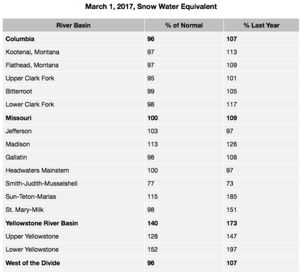
Continued snow through the end of the month helped most basin snowpack totals improve from below normal on Feb. 1 to near or above normal for March 1, according to the USDA Natural Resources Conservation Service in Montana.
Record-breaking snowfall for the month of February was experienced in northern and southern river basins of the state during the first two weeks of the month. Snow blanketed the Rocky Mountain Front at the beginning of the month, with low elevations and valleys receiving more than 3 feet of snow.
Flattop Mountain SNOTEL site in Glacier National Park reported a new record for February after receiving 12.5 inches of snow water during the month, well above the 30-year normal of 5.3 inches for February.
Further south, Cooke City received copious amounts of snow, prompting the first ever “Extreme” avalanche warning for the area when Fisher Creek SNOTEL received 10.9 inches of snow water between Jan. 31 and Feb. 11.
Statewide, 12 SNOTEL sites set new records for February totals, and six sites were second highest.
Lucas Zukiewicz, NRCS water supply specialist for Montana, said all basins experienced substantial improvements over the month with many now at near to above normal for March 1, and most basins are also near to above last year at this time.
“There are some sub-basins that remain below normal for this date due to the late onset of snowpack this year and sub-par November and January snowfall,” Zukiewicz said. “One major basin is still recovering from near record low early season snow; the Smith-Judith-Musselshell will be reliant on spring precipitation to make up ground before spring and summer runoff.”
February typically isn’t one of the big snow months for Montana, he said, but this year proved otherwise.
“Near-normal conditions on this date is great news, but there is still a month to a month and a half before snowpack generally peaks in the mountains of Montana,” Zukiewicz said. “The coming months and their weather patterns will play a critical role in the timing and magnitudes of water in the rivers this coming spring and summer.”
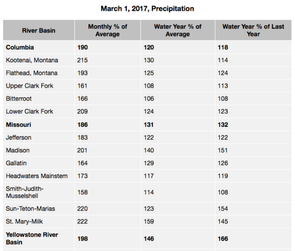
Streamflow forecasts across the state reflect the near to above normal snowpack in many basins, and above average water year-to-date precipitation. Many forecast points are near to above average for many rivers and streams for the April – July time period, but some remain below average due to lack of seasonal snowpack in some central Montana basins.
Detailed forecasts for 98 streams in Montana can be found in the March Water Supply Outlook Report.
Top Snowfall Years in Kalispell
Measured at Glacier Park International Airport between October and
September
1. 1996-97 143″
2. 1951-52 101.2″
3. 2008-09 99.99″
4. 1971-72 96.5″
5. 1942-43 93.1″
6. 1946-47 92.8″
7. 1990-91 91.8″
8. 1959-60 90.2″
9. 1968-69 87.8″
10. 1977-78 87.7″
This Year:
78.9″ (through March 6)