If and when this winter ever ends, spring will usher in a new season of outdoor adventures. Even though that prospect may seem imaginary in light of recent snowstorms, it’s time to start planning.
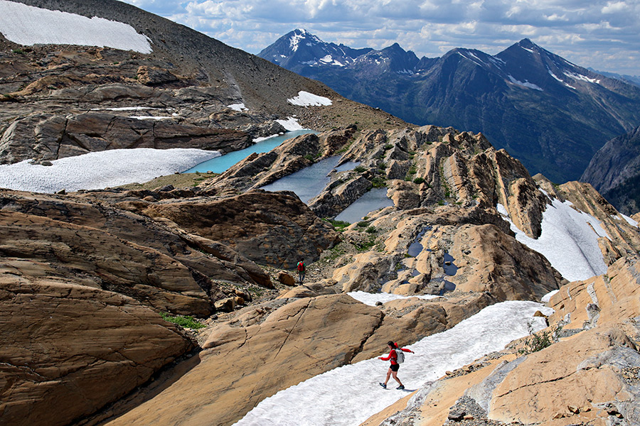
This corner of the state is home to an abundance of adventure opportunities. There’s a lifetime’s worth just between Glacier National Park and the Bob Marshall Wilderness Complex. Here are six excursions around the region that are perhaps overlooked but worth adding to your 2017 checklist. Some require advanced skills and fitness, but most only need a good pair of hiking shoes.

Explore the Route of the Hiawatha Trail
It was once considered one of the most scenic stretches of railroad in the country and now it’s one of the most spectacular hiking and biking trails. The scenic views are remarkable, but the most unique aspect of this 15-mile trail is its 10 train tunnels and seven sky-high trestles. Greatest of all, the St. Paul Pass Tunnel, also known as the Taft Tunnel, stretches 1.66 miles through the pitch-black heart of the Bitterroot Mountains at the state line of Montana and Idaho. The trail, named to the Rail-to-Trail Conservancy Hall of Fame, is downhill from east to west, making it family friendly. Shuttles are available for those wanting to go one way, while others make it a round trip. The trail is open from late May through September. Trail passes, shuttle tickets and bike rentals are available at Lookout Pass Ski Area, 12 miles east of Wallace, Idaho.
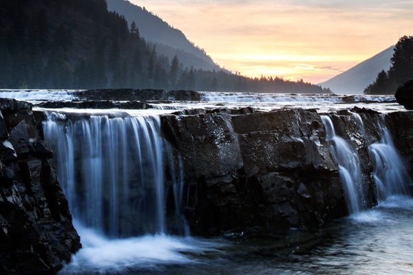
Catch a View of Kootenai Falls
The largest undammed falls in Montana are truly a sight to behold. The breathtaking views and awesome power of the river make for a great afternoon adventure for the whole family. Watch as the water surges through China Rapids and over the falls, dropping 90 feet in less than a mile. Be sure to take the brave trek across the swinging bridge that hangs 30 feet above the river as it crosses from bank to bank. Located in Lincoln County about seven miles northwest of Libby, this sight is considered sacred to the Kootenai Indians whose ancestors inhabited the region. Famed explorer David Thompson, a Canadian who worked for the North West Company and was among the first white men to witness the area in the early 1800s, traveled the river before running into the massive falls and portaging. Leonardo DiCaprio’s character in “The Revenant” was not so fortunate.

Ride the Divide
It’s dubbed the longest off-pavement cycling route in the world and winds right through Northwest Montana. The Great Divide Mountain Bike Route is a premier cycling adventure that crisscrosses the Continental Divide from Alberta to New Mexico. The entire route follows dirt roads throughout the Rocky Mountains and stretches 1,768 miles. It’s a popular ride for hardcore adventure cyclists and has received a recent boost in attention thanks to the award-winning feature film, “Ride the Divide,” which chronicles “the world’s toughest mountain bike race” along the route. Considered one of the most scenic stretches, the route through Northwest Montana and the Flathead Valley is a beauty. It’s worth a ride on its own. It travels south from Roosville through Eureka before climbing east and crossing the divide to the North Fork Road and then returning west. Altogether, it takes 100 miles to go from Roosville to Whitefish with idyllic campgrounds and scenic vistas along the way. Load up the bike, plan your trip and enjoy a two-wheeled multi-day adventure.
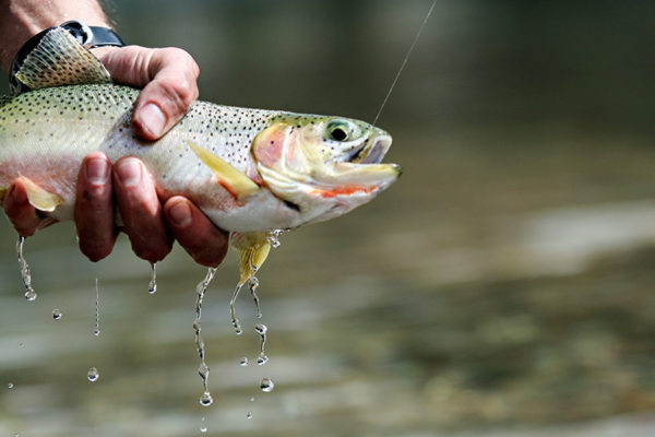
Fly Fishing the South Fork
You don’t have to be an expert angler to enjoy casting into the crystalline ripples of the South Fork Flathead River. One of our beloved local rivers is renowned as one of the most pristine and remote sections of water in Montana. It originates in the southern forest of the Bob Marshall Wilderness, at the confluence of Danaher and Youngs creeks, and flows north more than 60 miles before hitting Hungry Horse Reservoir. This is prime cutthroat country and the average catch can surpass 12 inches. The only access to the river is by trail; adventurous types will hike into the wilderness and ride out with a pack raft. The floating season is generally from mid-June through late August, and the river features Class II-III rapids with standing waves and shallow rocky shoals. Other eager anglers enter with horses or simply huff it with backpacks for overnight excursions. Be sure to read about the fishing regulations as different sections have different limits.
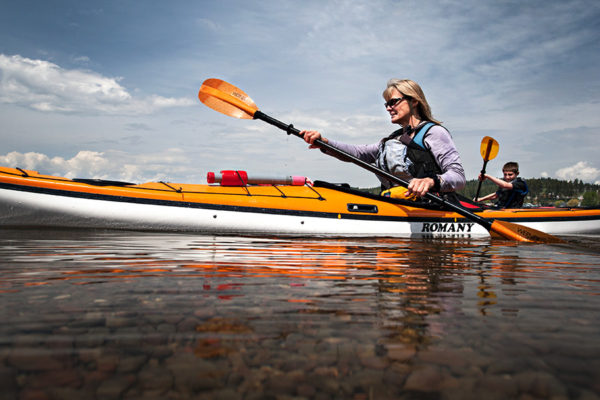
Paddle the Flathead Lake Marine Trail
Not every trail traces the dirt labyrinth of mountains. About a decade ago, John Sawyer, the manager of the state parks on Flathead Lake at the time and an avid sea kayaker, devised a concept that encouraged paddling adventures on the largest natural freshwater lake in the West. Sawyer crafted the Flathead Lake Marine Trail, envisioning a network of access points, stopovers and campgrounds along the vast shoreline, which stretches 120 miles all together. The idea is to offer watercraft users a detailed roadmap for exploring all the outdoor amenities on the lake, including the six state parks, fishing access sites and other worthy destinations. It also includes routes to three public islands — Wild Horse, Cedar and Bird. Camping is allowed at Cedar and Bird islands, while Wild Hose is day-use only. Remember, Flathead Lake is big — 30 miles long and as wide as 15 miles with 180,000 acres of ripples. Weather can change rapidly, and everyone is required to have personal flotation devices when out on the water.

Discover Lost Trail National Wildlife Refuge
Situated northwest of Marion in the picturesque Pleasant Valley, the Lost Trail National Wildlife Refuge is an idyllic mountain drainage with picturesque views and public access. Acquired in 1999, this 13.8-square-mile site is a great place for wildlife and migratory bird observation and photography. It also presents an impressive look at ancient geology. During the Pleistocene Epoch, glaciers plowed south from Canada and shaped the landscape with underlying Precambrian Belt rocks that are visible on the higher hills along the north edge of the refuge.