The Latest
— Growing fire northwest of Libby forces new evacuation orders
— Shelter opens in Libby for displaced residents
— Public meeting in Seeley Lake
Updated: Sept. 7, 5 p.m.
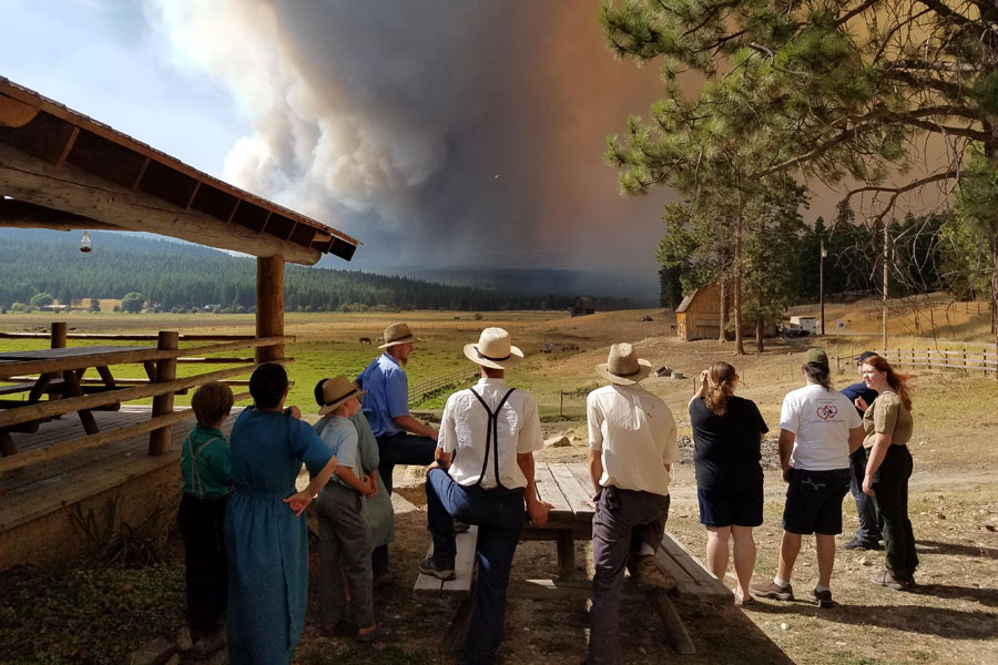
A growing wildfire about seven miles northwest of Libby has forced new evacuation orders while the entire region endures heavy smoke and raging wildfires.
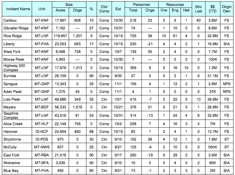
The West Fork Fire has grown to 7,337 acres and is zero percent contained, according to the latest update from officials. The Lincoln County Sheriff’s Office issued evacuation orders for Kootenai River Road from Quarts Creek to end of Bighorn Terrace; the north side of Kootenai River Road from North Central to Quartz Creek; and Lower Bobtail, including Burrell and Indian Pipe. Residents were advised to flee by noon Thursday.
Those evacuations are in additional to prior orders for residences in the 17 Mile Community of Pipe Creek Road; Upper Bobtail Road, north of and including Hutton Drive, along with Milton Drive, Bobtail Lane, Verna Court; and Quartz Mountain Road.
The American Red Cross of Montana opened a shelter at the Libby Assembly of God Church, 105 Collins Ave., in response to wildfire evacuations. All evacuees are welcome at the shelter, and all Red Cross services are free.
The West Fork Fire is exhibiting moderate fire behavior and backing in multiple directions, fire officials say. Crews successfully burned out an area to Lindy Peak, reducing available fuels for the fire.
Fire crews will continue to construct containment lines along the southern boundary of the fire. Structure protection and evaluating values at risk remain the priority.
HOW TO DONATE: Residents can help people affected by disasters like wildfires, as well as countless other crises at home and around the world, by making a donation to support Red Cross Disaster Relief. Gifts enable the Red Cross to prepare for and provide shelter, food, and other emergency assistance in response to disasters. Visit redcross.org/montana or call 1-800-272-6668 Contributions may also be sent to American Red Cross of Montana 1300 28th Street South, Great Falls, MT 59405
VOLUNTEER: Train as a Red Cross volunteer to be ready to help during a major disaster right here in Montana. Visit redcross.org/montana and click on “Volunteer” to start your application.
SMOKE CONDITIONS: The smoke conditions blanketing the Flathead Valley are listed as “very unhealthy” on Thursday. When air quality is considered “very unhealthy,” health officials recommend that people with respiratory or heart disease, the elderly, and children should avoid any outdoor activity. Everyone else should avoid prolonged exertion.
Local events have been canceled due to the hazardous air quality, including the Montana Dragon Boat Festival and the Flathead Invitational cross country meet. Organizers of the Two Bear Marathon are monitoring conditions and will decide Saturday whether the race will proceed.
The Gibralter Ridge Fire remains 7,291 acres and 27 percent contained. Firefighters will continue to mop-up, patrol and monitor the fire’s gradual growth toward William’s Creek. Crews have placed sprinklers and continue to patrol in pre-evacuation areas. The firelines continue to hold and fire growth is minimal, fire managers say. Pre-evacuation warnings and closure orders are still in place in the fire areas.
The Caribou Fire increased a couple hundred acres to 20,631 acres with 10 percent containment. Additional resources have been assigned to the fire, but aircraft will not be able to resume until the smoke clears and visibility improves. Fire crews and heavy equipment were used to improve fire line to the west and north, while joining lines to the south. Structure protection will continue to be the priority and area closure orders remain in place for the Caribou Fire.
A full evacuation order remains in effect for the West Kootenai area. Fire managers will continue coordinating with Canadian fire managers on fire suppression activities. A total of 40 structures, including 10 homes, were lost to the blaze.
The Moose Peak Fire is estimated at 5,717 acres at zero percent containment. This fire is exhibiting moderate fire behavior, torching, spotting, and backing in multiple directions. Fire crews will continue construction of containment lines on the eastern side of the fire. Structure protection assessment and evaluating homes are on-going in the Fisher Creek and McGinnis Meadows areas. Closure orders remain in place for the Moose Peak Fire. There will be a community meeting for Moose Peak and West Fork Fire tonight, September 7 at 6:00 p.m. at Libby Christian Church, 100 Kootenai River Road, Libby, MT.
The Highway 200 Complex fires total 18,722 acres and are at different stages of containment. Minimum fire growth have occurred over the last few days and suppression tactics have been largely successful. Weather and limited firefighting resources continue to challenge fire operations. Structure protection assessment and strengthening existing containment lines will continue to be the priority. Once visibility improves, aircraft will again be able to fly and assist ground crews.
The Sprague Fire in Glacier National Park has calmed slightly thanks to heavy smoke that is dampening the flames. Structure protection has been underway at Lake McDonald Lodge.
An evacuation order remains in effect from the south end of Lake McDonald north to Logan Pass. This includes the North McDonald Road. It does not include the Apgar area at this time. Logan Pass is still accessible from the east side of the park. The duration of the evacuation is unknown at this time, park officials say.
Due to the large number of nearby fires, air quality and visibility will continue to be very poor. People with smoke sensitivities, should limit their exposure and exertion while outdoors. The National Weather Service said there is a small chance for moisture on Sept. 8 but most likely the smoke will hinder any substantial precipitation from falling. No other rain is predicted for at least the next week, according to NWS.
The Adair Peak Fire was started by lightning on Aug. 12 and fire managers have been monitoring the fire, which is now at 1,375 acres. The fire is burning in a remote area of the park on the south side of Logging Lake. Fire managers expect the fire behavior to moderate as this fire enters old fire scars.
On Wednesday, the Glacier National Park pack string supplied firefighters with materials and supplies necessary to implement structure protection around the historic cabins located at either end of Logging Lake.
Waterton Lakes National Park, north of Glacier National Park in Alberta, is under a voluntary evacuation alert due to a nearby wildfire. Parks Canada, the agency overseeing the national parks, issued the evacuation advisory on Tuesday due to the 11,000-acre fire burning in the Kishinena Creek area of British Columbia’s Flathead Valley.
All trails and water access in Waterton have been closed. The townsite and the main access road from the Highways 5 and 6 entrance gate remain open. Emergency and wildfire suppression crews are currently on standby within the park.
The Rice Ridge Fire near Seeley Lake has burned more than 120,000 acres and is listed as 5 percent contained. The fire continues to actively burn with aggressive growth, according to fire managers.
A public information meeting is Thursday night at 6 p.m. at the Mission Bible Fellowship Church, 3158 Highway 83. It will be live streamed on the Lolo National Forest Facebook page.
Incident Management Situation Report https://www.nifc.gov/nicc/sitreprt.pdf