Cooler Weather Calms Fires Across Northwest Montana
Despite windy conditions, Sprague Fire does not move toward West Glacier
By Justin Franz & Dillon Tabish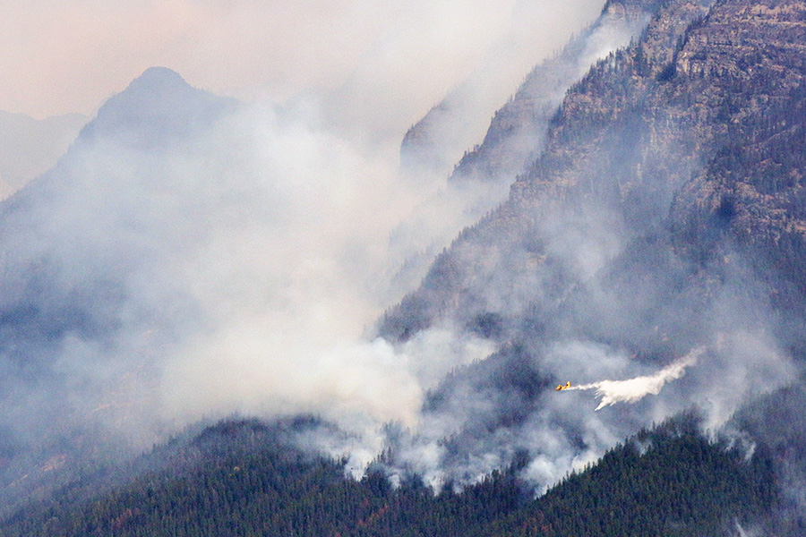
The Latest
— Cooler weather calms fires; snow falls at Logan Pass
— Fire near Libby asbestos mine raises concerns
— Sprague Fire grows to nearly 16,000 acres
Updated: Sept. 14, 4:40 p.m.
Colder temperatures and precipitation are giving firefighters the upper hand on a number of large wildfires across Northwest Montana.
The transition into autumn is underway with cooler temperatures and moisture arriving this week. Temperatures in the Flathead Valley on Thursday were dropping 15-20 degrees from recent days, and precipitation was expected to fall across the region. Logan Pass in Glacier National Park received light snowfall on Thursday, and the mountains around Seeley Lake are expected to receive more than 3 inches of snowfall in the coming days, according to the National Weather Service.
The Flathead Valley is expected to receive light rainfall through Saturday but the cooler temperatures could be the most significant deterrent to fire activity. Frost could arrive by Sunday morning.
“This is good news for fires. Bad news for gardens,” Travis Booth, a meteorologist with the NWS, said.
Next week is expected to see similar cold temperatures and moisture across Northwest Montana.
The fall weather is welcome in a corner of the state that experienced exceptionally hot, dry weather this summer. July and August ranked in the top three on record for both hot and dry conditions in the Flathead Valley, Booth said.
The Sprague Fire in Glacier Park grew to nearly 16,000 acres on Wednesday, inching closer to Lake McDonald but has not impacted any new structures or residences. Late Wednesday, Apgar and West Glacier were put on a pre-evacuation notice over concerns about changing winds that threatened to bring the fire south toward the U.S. Highway 2 corridor. The Going-to-the-Sun Road remains closed from Apgar to Logan Pass.
The Elder Creek Fire on the U.S.-Canadian border north of Polebridge continues to burn, resulting in a number of area trail closures. As of Thursday, it has burned 2,547 acres in the U.S. and Canada, 282 acres in Glacier National Park. The Adair Peak Fire near Logging Lake is continuing to be monitored and has burned 3,374 acres.
North of Glacier, in Waterton Lakes National Park, the Kenow Fire has burned 88,000 acres in southern Alberta, prompting the closure and evacuation of that park. Earlier this week, the fire burned a visitor center at the Waterton townsite.
The West Fork Fire near Libby has burned 16,840 acres and is now 10 percent contained. Firefighters expect cooler weather to calm the fire in the days to come. Pre-evacuation orders remain in effect for Bobtail Lane, Bobtail Meadow Road, Red Rose Ranch Road and Kentana Place.
Although the fire has not threatened the former W.R. Grace & Co. asbestos mine, local officials are preparing for the possibility that the fire could spread east toward an area designated by the Environmental Protection Agency as OU3.
For years, officials have been concerned about a fire at the old asbestos mine that could produce hazardous smoke. The Kootenai National Forest maintains a small group of firefighters that is specially trained to battle fire at the old asbestos mine. If the fire were to spread into OU3, local, state and federal agencies would deploy the Libby Asbestos Response Plan and air quality monitors would be set up throughout the county.
“The agencies have spent months coordinating and planning for a wildfire in the former vermiculite mine site and we will continue to plan and practice for an actual event” said Commissioner Mark Peck. “The coordination between all of the agencies is important.”
The Caribou Fire has burned 23,210 acres on the west side of Lake Koocanusa and is 37 percent contained. A pre-evacuation notice remains in effect for West Kootenai. The Gibralter Fire east of Eureka has burned 12,700 acres and is 27 percent contained. A public meeting to discuss both fires will be held at the West Kootenai Store on Sept. 15 at 7 p.m. The Weasel Fire near Tuchuck Mountain northwest of Whitefish has burned 3,900 acres, prompting area closures on the Kootenai and Flathead National Forests near the Canadian border.
Four large fires are currently burning on the Flathead National Forest. The Strawberry Fire has burned 13,025 acres in the Bob Marshall Wilderness. The Rice Ridge Fire has burned 155,000 acres near Seeley Lake, including more than 40,000 acres on the Flathead forest. The Scalp Fire has torched 17,000 acres deep in the Bob Marshall Wilderness. And the Dolly Varden Fire has burned about 424 acres.
The Highway 200 Complex near Plains includes the 17,392-acre Sheep Gap Fire, the 10,592-acre Deep and Miller Creek Fire, 4992-acre Cub Creek Fire and the 152-acre Readers Fire. A public meeting is being held about the complex tonight at 7 p.m. at the Plains High School.