Kalispell set a new record for low temperatures on Feb. 20, as thermometers hit minus 16 degrees. The previous record was 13 degrees below zero, set in 1936, according to the National Weather Service.
By midweek, there was plenty of blue sky and sunshine in the Flathead Valley, though overnight cloud cover on Feb. 20 helped temperatures from plummeting further.
The National Weather Service in Missoula predicted continued cold, with another series of storms expected to bring snow into the mountains and valleys starting late Friday night.
Snow will likely hit the Montana/Idaho border the hardest, NWS reported, with 1 to 4 inches expected in the valleys and 8 to 18 inches expected in the mountains. The snow should let up a bit on Sunday morning, but picks up again later in the day, with a few inches of snow possible Monday.
Temperatures are expected to remain below normal through next week, NWS reported.
Lake effect snow is also developing around Flathead Lake, with Yellow Bay receiving light snowfall.
The NWS also noted that wind gusts nearing 40 mph could make travel difficult east of the mountains on U.S. Highway 2, with the wind creating snow drifts on the highway from Browning to Marias Pass.
Expect tough driving conditions, with visibility of less than a mile at times in the blowing snow. Conditions may be more difficult along rural roads close to the Rocky Mountain Front. The wind is expected to die down in the evening.
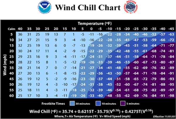
Wind chill can be dangerous; check the chart below for estimated frostbite times.