The Latest
—Boundary Fire burning in Glacier National Park one mile west of Waterton Lake reported at 1,200 acres
—Parks Canada closes all of Waterton Lakes National Park, including waterbodies
—Dynamic weather expected on the Howe Ridge Fire along Lake McDonald
—Gold Hill Fire near Libby grows to 2,830 acres
Updated: Aug. 24, 1:13 p.m.
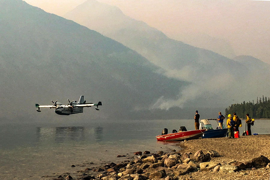
As firefighters on the Howe Ridge Fire along Glacier National Park’s Lake McDonald prepare for a “dynamic” weather day, a new blaze is growing within park boundaries near Waterton Lake.
The 1,200-acre Boundary Fire was reported Aug. 23 and is located in the Boundary Creek Valley near the Campbell Mountain area west of Waterton Lake in northeast Glacier National Park. In response, Parks Canada on Friday closed all of Waterton Lakes National Park, including all waterbodies, except for the Waterton Townsite and Highway 5/6 and Chief Mountain Highway.
Parks Canada deployed initial attack aerial resources, but officials were unsuccessful in limiting the fire’s growth, according to a news release this morning. Parks Canada and Glacier National Park officials cleared hikers from the area and evacuated the Waterton River Backcountry Campground.
Waterton Lake Trail, the North Boundary Trail and the Waterton River Backcountry Campground have been closed. Additional closures are expected to day and more information will be shared as it becomes available.
The Boundary Fire is burning one mile west of Waterton Lake and was reported to be fast-growing, with flame lengths of up to 100 feet. The park is implementing structure protection measures in the Goat Haunt area.
On Friday, air resources were being used to slow the spread of the fire eastward toward Waterton Lake, as conditions allow.
National Park Service and Parks Canada are closely coordinating efforts.
Meanwhile, officials report that firefighters on the 10,802-acre Howe Ridge Fire have made progress reinforcing existing trail systems and roads as containment lines in the event the fire reaches them.
The lightning-caused fire is 10 percent contained.
Today is predicted to be a “dynamic” weather day, with gusty winds expected as a cold front moves through the area. Thunderstorms are also possible in the northern portions of the park.
Aerial resources continued to control spot fires Thursday in the Camas Drainage using bucket drops, while planes also used fuel-filled Ping-Pong ball-like spheres to create a uniform fire edge to control the direction of the fire’s spread as it approaches the sprinkler-reinforced trail systems at the north end of the fire in an ongoing effort to protect the Going-to-the-Sun Road.
The fire continues to burn in sparse fuels on the ridges of Mount Stanton and the south slopes of Mount Vaught on the north end of the fire. A sprinkler system on the Upper McDonald Creek trails is in place to serve as a fire line, should the fire move downslope towards the Going-to-the-Sun Road.
Crews are working to protect the Trail of the Cedars and other facilities at the Avalanche Creek Campground in the event the fire reaches that area. The southwest edge of the fire continues to back towards the Inside North Fork Road. Firefighters and heavy equipment are being used to remove dead trees and brush to prepare the road to serve as a fire break. Structure protection is in place in the Fish Creek Campground.
As of Thursday, the fire has cost $2.3 million to suppress.
At least four fires are currently burning on the Flathead National Forest.
The Paola Ridge Fire has burned 598 acres near Essex. The Coal Ridge Fire near Polebridge has burned 280 acres and is 2 percent contained. Firefighters hope to fully extinguish the blaze with water drops in the coming days. The Whale Butte Fire has burned 327 acres near Polebridge, forcing a pre-evacuation warning for a small number of homes.
The Gold Hill Fire continues to burn north of Libby, prompting a pre-evacuation warning along Pipe Creek Road, between mile markers 11 and 13. As of Friday morning, the fire has burned 2,830 acres. Other fires in Lincoln County include the 6,365-acre Davis Fire, the 681-acre Ten Mile Fire and the 1,265-acre Sterling Complex Fire.