
So you want to go hiking.
There are a lot of reasons why people hike. Probably the most obvious are for exercise and to get outside. It can be process-driven or a means to an end. Hiking might get you to a great fishing hole or a gorgeous stage for an Instagram or selfie post, or get photographers and artists to new subjects. For some it is an escape from troubles and stress, and for many it is deeply rooted in a passion for the wild and natural world. Some people say wild places are their church, a way to get into a zone or reach their Zen, and others are motivated by something as simple as the guiltlessness of pigging out after a big hike or the amazing wallop of a cold beer after hiking on a hot summer day.
Understandably, hiking can be a bit daunting for those unfamiliar with wild and wooly trails. If you have been more of a sidewalk or treadmill walker in the past, the solitude, rawness and presence of wildlife can be a little scary and nerve-wracking. A fear of wildlife might even keep people off the trail: “Lions and tigers and bears, oh my!” Don’t let sensational movies and news stories warp your ideas about your chances of experiencing a wild animal attack. They happen, but not often. On the other side of the discussion is the hiker whose goal is to see wildlife.
Be prepared for smaller challenges on the trail than can add up in a hurry — huffing and puffing your way up a hill on a hot day combined with dust in your mouth and insects whirring in your ears will probably not be the moment you fall in love with hiking.
Don’t fool yourself. In spite of the bonuses and benefits, hiking can be grueling, especially for the unprepared. You might face a wide range of weather conditions, including heat, cold, wind, rain and snow, which are often more extreme in the mountains. But overcoming adversity — boldly facing challenges and setting goals farther and higher — is likely one of the reasons hiking can be addictive, with excitement, exhilaration and a natural high from endorphins, dopamine and adrenaline.
There will also be those moments of awe and bliss along the way: when you break out of a lush forest to catch a glimpse of a snow-capped mountains against intensely blue sky; when you pass through a meadow sprinkled with red, blue, yellow, purple, white and orange wildflowers swaying in a summer breeze; or the feeling you get when you plunge into an alpine lake as it seems to spit you back out of the icy water.
It is good to stay focused as you put one foot in front of the other, but don’t forget to take time to use all your senses. Do a 360 when you reach a vista, listen for birds as you pass through a forest, smell the sweetness of pine trees or the damp earth as you pass a creek, feel the cooling of a gentle breeze, and taste a succulent huckleberry.
Like any endeavor, there are steps you can take to help ensure that it is a safe and savory experience. Sure, hiking has its ups and downs, but step by step, you will reach astoundingly beautiful and pristine places and, hopefully, gain a newfound passion.
SPRING TRAINING
Spring is a great time to get in shape for the hiking season, which is fairly short in the high country, where access to trails often isn’t possible until the end of June, or even later, and can end with the first big snowfall in October. Get a jump-start by taking trails on the valley floor and at lower elevation to try out your hiking legs and test your boots and equipment.
Places for Spring Training
Whitefish Trail – 12 trailheads and 42 miles of trails in Whitefish area
Lone Pine State Park – 7.5 miles of trails
Herron Park/Foys to Blacktail Trail – 18-mile trail from Herron Park to Blacktail Mountain with a network of many more miles of interlocking trails
Swan River Nature Trail – 2 miles from Bigfork to the Swan River Bridge
GEARING UP
Personal needs and hiking style will help you customize your gear and pack contents. Finding the right boots is probably one of the most important steps to ensure a good hiking experience. You can easily take 2,000 steps in one mile, meaning if you hike five miles you will land on your feet 10,000 times. Imagine 10,000 steps on blistered or tender feet.
Clerks at local outdoor shops are often hikers and knowledgeable about merchandise, so they can help in selecting the right boot as well as other gear. Shorter hiking boots are available, but a higher boot offers more support and protection. Certain brands of boots might be known for characteristics such as a roomy toe box or a stiff sole, so ask to be directed to a boot that suits your feet as well as your hiking plans and goals. An insole can help customize the boot to your feet, and the right sock can be critical to preventing blisters and ensuring boot comfort.
You might want to consider purchasing trekking poles; they aren’t just for extreme terrain or old people. Poles turn you into a quadruped to provide stability as well as distributing weight to reduce stress and impact on your hip, knee and ankle joints. You also reap the benefits of getting more of a whole body workout by using and building upper body muscles.
Another key item is water. It is my experience that hikers often wish they had more. It helps to pre-hydrate on the way to the trailhead and have an extra bottle at the car for after the hike so you don’t have to carry as much water in your pack. You might also consider carrying a lightweight water filter. Don’t let those crystal clear streams seduce you — they can carry giardia parasites.
Staying nourished is also important. The grazing approach helps maintain energy. Energy bars, nuts, dried fruit, fresh fruit, cheese, hard salami and a sandwich are good options.
Long pants will offer extra protection from brush, insects and sun, but might be too warm for a sunny, summer day. Some pants convert to shorts and others have a roll-up option. Temperatures vary drastically from morning to afternoon, so you will either want to start with, or pack, an extra layer.
Carry bear spray in a place where you can reach it quickly and know how to use it.
PROGRESSIVE HIKING
You might want to start the season with flatter, shorter hikes to gauge your comfort level and endurance. It helps to have a goal and a destination — a lake, waterfall, summit or viewpoint — that will also provide a reward and rest stop mid-hike. Solitude is important for some hikers, while others enjoy the camaraderie and security of hiking with others. Glacier National Park and Jewel Basin are extremely popular, offering a number of moderate hikes and high-elevation trailheads that dish out instant gratification with big views. As a result, you will encounter more traffic at parking lots and on the trail, so consider an earlier or later departure or hitting trails in June, when snow conditions permit, and in the autumn.
Rating a hike’s difficulty doesn’t lie simply in the numbers, because not all miles are equal when factoring in a trail’s conditions, location and grade. Five miles on a flat grade will feel a lot different than five miles with significant elevation gain, especially if you start at a trailhead at five or six thousand feet like at Logan Pass, which lies at 6,647 feet. As you gain elevation, you might notice that you get winded more easily, which is caused by lower air pressure and oxygen levels that make it harder for oxygen to enter your vascular system. Take it a little slower and stop to take in the views, giving you a chance to catch your breath.
Visit your local ranger stations, park visitor centers or websites for current conditions, maps, rules, trail etiquette and other information.
FIRST STEPS
Hiking options are endless in Northwest Montana, and close to the Flathead Valley you have Glacier with over 700 miles of trails and Jewel Basin with 50. Here are a few suggestions for level or moderate-grade hikes to get you started. Some also include “next steps” to help you continue a little farther if you feel inspired, or give you something to shoot for as you gain confidence and stamina and feel ready for more grade and varied terrain.
Distances are one way.
Glacier National Park
Lake McDonald West Shore
Distance: 7.4 miles
Trailhead: 0.2 miles north of Fish Creek Campground or 2.8 miles west on North Lake McDonald Road
Hike as far as you want along over seven miles of a mostly level trail following the west shore of Lake McDonald.
Avalanche Lake
Distance: 2.3 miles
Elevation gain: 500 feet
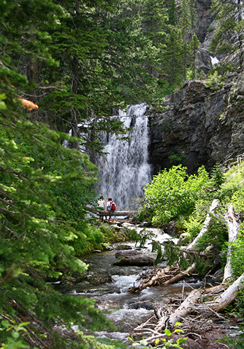
Trailhead: Avalanche Gorge, reached from the Avalanche Picnic Area. This is one of the most popular hikes in Glacier to a gorgeous lake surrounded by steep mountains streaming with ribbon-like waterfalls as snow melts.
Hidden Lake Overlook
Distance: 1.5 miles
Elevation gain: 460 feet
Trailhead: Logan Pass Visitor Center
There are lots of people, but also lots of spectacular views and wildlife on this 1.5-mile hike on a boardwalk and trail to Hidden Lake Overlook. Go early or catch a free shuttle from Apgar because the parking lot fills up quickly in the summer.
Next step: Hike 1.2 miles down to the lake, but keep in mind you will have to climb 780 feet to return to the overlook. Another more adventurous option is to turn left shortly before you see the overlook onto a trail between two intermittent ponds. This trail side-hills both sides of the Continental Divide to reach a saddle between Reynolds and a geological feature known as the Dragon’s Tail.
Upper Two Medicine Lake
Distance: 2.2 miles (when combined with a boat ride from Two Medicine Lake)
Elevation gain: 350 feet
Trailhead: From boat launch
Next step: Take the 3-mile North Shore Trail (moderate elevation change) instead of the boat on the return.
Rockwell Falls
Distance: 3.4 miles
Elevation gain: 375 feet
Trailhead: South Shore Trail
This hike dishes up a variety of terrain with pretty meadows, outstanding views and a fun suspension bridge.
Next step: Cobalt Lake
Distance 5.8 miles (can be shortened by 2.4 miles round trip if you take the boat to/from the trailhead at the head of the lake)
Elevation gain: 1,400 feet
Continue on from the falls up the long U-shaped valley to reach Cobalt Lake for a swim and a picnic. You can also continue to Two Medicine Pass with its lush green meadows set against red argillite rock.

Jewel Basin
Access to the Jewel Basin is reached by turning off Highway 83 to Echo Lake Road for three miles and then right onto Foothills Road and a right turn to Jewel Basin Road for seven miles. Drive cautiously on this rough road in a vehicle with good clearance.
Twin Lakes
Distance: 2.5 miles
Elevation change: +770 feet and -200 feet
Trailhead: Camp Misery
Take Trail #8 from the parking lot for .6 miles and then head north on Trail #8 to a scenic point. The trail side-hills on the south side of the draw to reach Twin Lakes Notch, where you drop down to reach the two lakes.
Loop Around the Mountain
Distance: 4.4 miles
Elevation gain: 1,100 feet
Instead of dropping down at Twin Lakes, continue on Trail #7 through Picnic Notch, past the Trail #68 junction to the ridge and the intersection for Trail #717, which has great views of the valley.
Tongue Mountain Area
Distance: 3 miles
Elevation gain: 900 feet
Trailhead: #717
This is generally less busy and offers plenty of nice spots with expansive views, dramatic rockslides and pretty meadows where you can end your hike before the summit. Head up Trail #8 until you reach Twin Lakes Notch, where you will turn left on Trail #7 passing through a meadow and to a high point.
Birch Lake
Distance: 3 miles
Elevation change: +610 ft. and -160 ft.
Take Trail #8 and #68 or Trail #717 from the parking lot and stay on Trail #7 at a junction where four trails intersect. The trail takes you through trees and along a steep side hill above Martha Lake to reach the lake. There is a climb on the return.
Next steps: You can do a mile loop around the lake or cross Birch Creek at Birch Lake to continue three miles past In-Thlam-Keh Lake and drop down to Crater Lake.
Additional elevation change: -500 feet
Mount Aeneas
Distance: 3 miles
Elevation gain: 1,800 feet
Trailhead: Trail #717 or the gated road
This is your chance to climb a mountain early in your hiking career because of its fairly moderate grade and relatively short distance to capture spectacular views and maybe some mountain goats.
Next step: Drop down to Picnic Lakes and loop over Picnic Notch to Trail #717 on the return.
Distance: 1.2 miles
Elevation loss: 888 feet
Elevation gain: 100 feet
Read more of our best long-form journalism in Flathead Living. Pick up the spring edition for free on newsstands across the valley, or check it out online at flatheadliving.com.