A Mile-by-Mile Guide to the Sun Road
The iconic Going-to-the-Sun Road is one of the most scenic thoroughfares in North America
Mile marker 1: West Entrance
This is the most popular entrance in Glacier National Park and is open year-round. The community of West Glacier is full of amenities, including gas, food and recreational activities. Entrance into the park costs $30 for a vehicle seven-day permit; $15 for a single person; $25 for motorcycles; and $50 for an annual pass.
Mile marker 3: Lake McDonald
Stretching 10 miles long and 1 mile wide, this is the largest body of water in the park. It spans a surface area of 6,823 acres and is ideal for boating and sight-seeing.
Mile marker 11: Lake McDonald Lodge
Built in 1913, this historic lodge is perched along its namesake lake with 82 guest rooms, a rustic dining room, reading area and lounge. This Swiss chalet-style lodge was based on a designed by famed architect Kirtland Cutter, whose other works include the Davenport Hotel in Spokane and the Conrad Mansion in Kalispell.
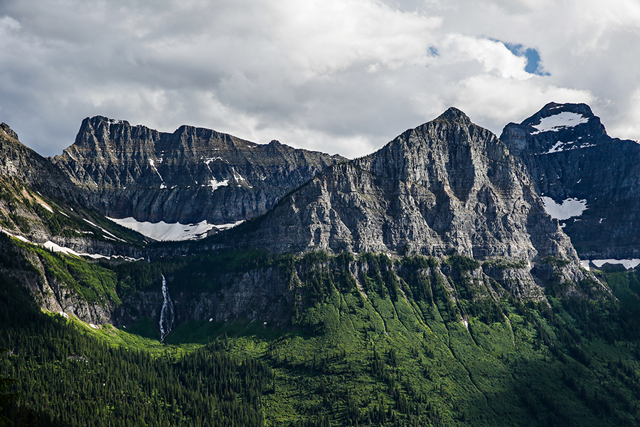
Mile marker 12: McDonald Falls
This small pullout rewards visitors with a breathtaking show of force as water gushes through jaded rocks.
Mile marker 16: Avalanche Creek and Trail of the Cedars
This busy roadside spot features a large campground and the most popular hike in the park, the 2.5-mile jaunt to Avalanche Lake. Experience the wheelchair-accessible Trail of the Cedars, which loops through a sylvan setting of towering trees and peaceful forest. Be sure to get here early to land a parking spot, or take a shuttle from Apgar.
Mile marker 23: West Side Tunnel
This is one of two tunnels along the Sun Road and roughly 17 prominent masonry and concrete structures along the Sun Road.
Mile marker 24: The Loop
This popular stop is the only official switchback along the serpentine Sun Road. Shuttles frequent this location and hikers frequently use this to reach Granite Park Chalet or end their jaunt along the Highline Trail. From here, enjoy the view of Heavens Peak to the west, stretching 8,987 feet into the sky.
Mile marker 27: Bird Woman Falls
Visible in the distance, these majestic waterfalls drop 560 feet from the north face of Clements Mountain.
Mile marker 28: Haystack Falls
The Sun Road straddles these scenic falls, which cascade down the Garden Wall at Haystack Butte into McDonald Creek far below.
Mile marker 29: Weeping Wall
Roll up your windows.
Mile marker 30: Big Bend
This large turnout is ideal for pulling over and enjoying the scenic panorama featuring Cannon Mountain, Mount Oberlin, Heavens Peak and Clements Mountain in the distance. Around this same area are the Triple Arches, a 60-foot section of road featuring impressive stone masonry.
Mile marker 32: Logan Pass Visitor Center
At 66,46 feet, this is the highest elevation point along the Sun Road. This is the primary parking lot in the heart of the park and it fills up early. There are restrooms near the visitor center and picturesque views of Reynolds Mountain and Clements Mountain in the distance, along with meadows of wildflowers. This is a good trailhead for several popular hikes, including the Highline Trail and Hidden Lake.
Mile marker 33: Big Drift
During winter, upwards of 80 feet of snow typically pile up at this location, which creates extra work for plow crews that finish their spring clearing efforts focused entirely on this area.
Mile marker 34: East Side Tunnel
Many consider this to be one of the most impressive engineering feats along the Sun Road. This 408-foot tunnel through Piegan Mountain was built in 1932 as part of the road construction, but this structure was entirely built by hand labor instead of powered equipment.
Mile marker 35: Siyeh Bend
This winding section of road is the trailhead for many popular hikes, including Siyeh Pass and Piegan Pass.
Mile marker 40: Sunrift Gorge
This stream cuts through a steep canyon of bedrock. Check out the Baring Creek Bridge.
Mile marker 44: Rising Sun
A popular campground with 84 sites, this location has a camp store, lodge and picnic area, as well as access to St. Mary Lake.
Mile marker 50: St. Mary Visitor Center
This is the east entrance to the park and offers a visitor center with interpretative info, a ranger station and more.