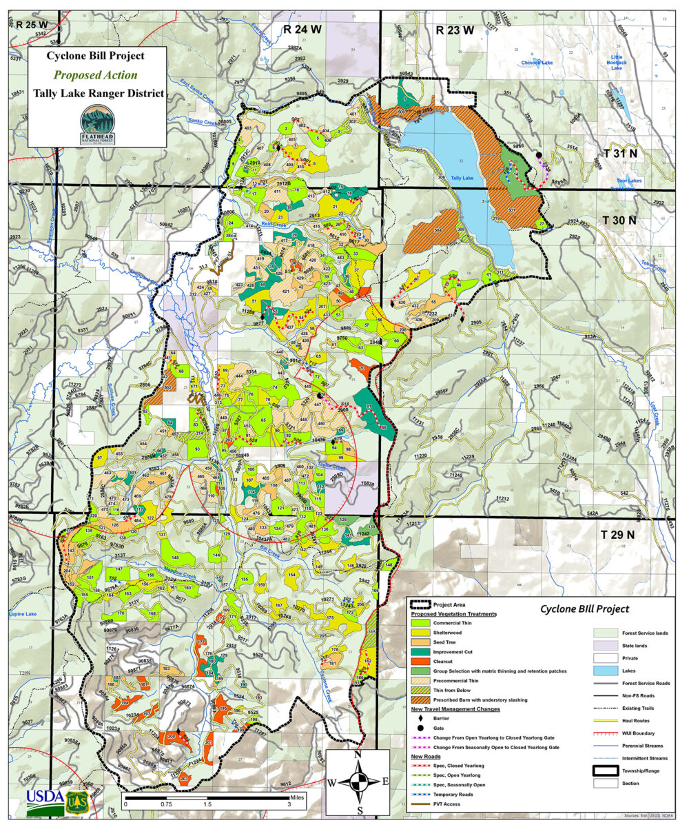
Flathead Forest Lays Plans to Reduce Wildland Fire Fuels Near Tally Lake
Located 13 miles west of Whitefish in the wildland-urban interface, the Cyclone Bill Project spans 40,880 acres and includes Tally Lake and Logan Creek
By Tristan Scott
As part of a strategy to reduce wildland fire fuels on a densely timbered tract of land surrounding Tally Lake, about 13 miles west of Whitefish on the wildland-urban interface (WUI), the Flathead National Forest is seeking public feedback so it can begin thinning trees and conducting other treatments on more than 40,000 acres of mostly public land.
Dubbed the Cyclone Bill Project and located within the Tally Lake Ranger District, the aim of the plan is to reduce tree densities and fuel loading on the WUI, buffering residential communities from hazardous, fire-prone sections of the forest. The project would also improve diversity and resilience of the trees and “contribute to continued timber production and economic sustainability,” according to a U.S. Forest Service proposal made public on March 7.
As part of its environmental analysis, the agency will accept comments for 30 days, through April 7.
A proposed action document available on the Flathead National Forest website describes a forest in which conditions are considered undesirable under the 2018 Forest Plan. For example, as some tree stands ringing Tally Lake have matured, the density of younger stands have reached a point at which “vigor decreases and tree mortality through self-thinning of the stand occurs,” leading to unhealthy tree stands, a glut of fuel loading and potentially hazardous wildfire conditions.
“Tree growth and fire exclusion in these stands has resulted in dense forest conditions that could support an intense crown fire with increased resistance to control, which could threaten life and private property within the wildland-urban interface,” according to the proposal.
The absence of wildfire in the area coupled with the district’s relatively low harvest history has contributed to the undesirable conditions, as have insects and disease, creating “multiple layers of tree canopies that serve as ladder fuels, and accumulations of surface fuels.”
“It is desirable to reduce wildland fuel in areas where wildland fire pose a threat to communities and community assets,” the proposed action states. “The Cyclone Bill project area is located west of communities at risk from wildfire and topographically aligned with prevailing wind patterns increasing potential fire behavior. Reduced risk can be accomplished by breaking fuel continuity at the landscape level, managing for lower tree densities, and reducing surface fuels within the wildland-urban interface.”
Land ownership within the project area is approximately 81% National Forest System land, 13% private and 3% state-owned land. About 55% of the project area, or 22,636 acres, is located within the wildland-urban interface, which is established by the 2021 Flathead County Community Wildfire Protection Plan.
The project activities include 9,694 acres of commercial timber harvest and 4,838 acres of noncommercial vegetation treatments, including thinning and prescribed burning. It would require the additional construction of approximately 15 miles of road to the National Forest System and three miles of temporary road.
Portions of the Cyclone Bill project area were identified as priority areas for focused attention on fuels reduction in the 2020 Montana Forest Action Plan, which evaluated conditions of Montana’s forests and crafted a strategic approach to improve forest health and reduce wildfire risk to communities, prioritize actions to conserve wildlife, protect watersheds, build community resilience, and maintain a strong and diverse recreation, wood products, and tourist economy.
A preliminary proposed action, descriptions of the management activities, and project area map is available on the project page, as well as instructions on how to provide comments on the project: https://www.fs.usda.gov/project/?project=63658
For additional information, members of the public should contact Kira Powell at [email protected] or (406)758-3508.