Wildfires Prompt Evacuations Near Hungry Horse Reservoir as Smoke Blankets Flathead Valley
Smoke from more than two-dozen fires burning across the region is contributing to 'unhealthy' air quality
By Micah Drew
The 1,472-acre Tin Soldier Complex comprising four lightning-caused fires on the Spotted Bear Ranger District of the Flathead National Forest on Wednesday morning prompted evacuations in the residential community of Heinrude, located near Hungry Horse Reservoir. A Type 3 Interagency Team on Aug. 2 assumed management responsibilities of the incident, which includes the Kah Mountain, Bruce, Sullivan and Con Kelly fires.
Firefighters on Wednesday were working to protect homes and structures in the area, including the Stony Communications Site, a hydro-electric plant, as well as about 19 commercial guest ranches and homes within the Heinrude Creek residential community on the westside of Hungry Horse Reservoir Road. Flathead County sheriff’s deputies have been dispatched to notify all affected residents.
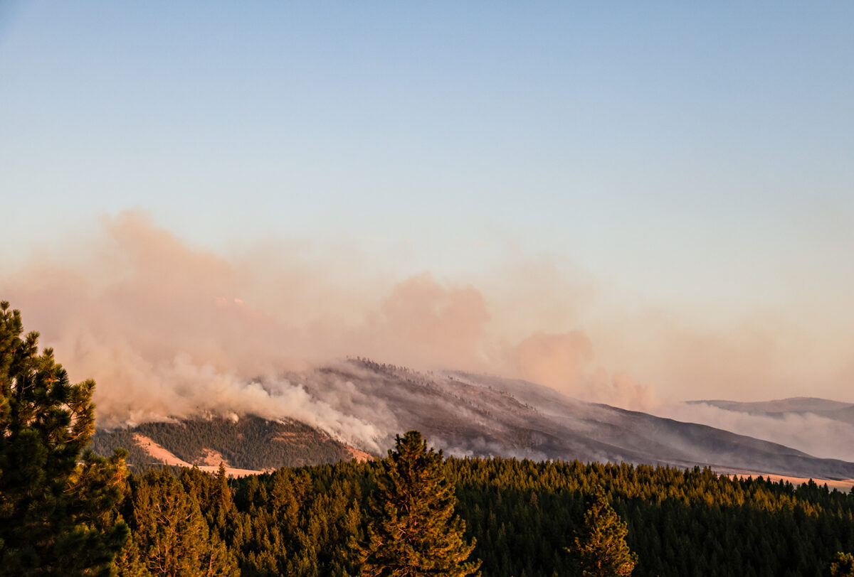
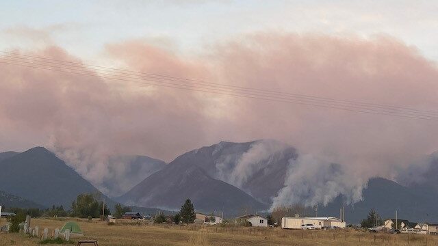
The Tin Soldier Complex is among the nearly two dozen wildfires burning in Flathead and Lake counties. Over the last 24 hours, smoke from the myriad blazes began to settle into the Flathead Valley, spiking air particulate matter concentrations across the region. Air quality in Kalispell, Whitefish and Columbia Falls was “unhealthy” late Wednesday morning, and trending worse, according to data from Purple Air sensors in each city. Down near Seeley Lake where the nearby Colt Fire has been burning for two weeks, air quality reached “very unhealthy” in some areas.
The Department of Environmental Quality (DEQ) in conjunction with the Department of Public Health and Human Services issues outdoor activity guidelines for all individuals to consider when air quality begins to decline. Under “unhealthy” air quality, individuals are advised to remain indoors as much as possible. In addition to using air quality sensors, DEQ also has guidelines to gauge air quality based on visibility of known locations, such as nearby mountains, which can be viewed here.
Air quality may look different across different agencies and websites due to differences in data reporting — 24-hour and one-hour averaged data are less likely to show sharp increases or decreases in air quality compared to shorter duration readings.
A prominent visual source of smoke to residents on the north end of the Flathead Valley is from the Ridge Fire burning six miles southeast of Hungry Horse. The fire has torched more than 400 acres since July 30, and fire officials have not yet determined a cause. The Flathead National Forest has responded to 17 separate fires over the last 72 hours.
Down in Lake County, the Niarada and Big Knife fires have supplanted the Colt Fire in Seeley Lake as the region’s top priorities, according to the latest situation report released by the interagency Northern Rockies Coordination Center. On Wednesday morning, a Complex Interagency Management Team (CIMT) began managing the two fires, along with the Mill Pocket fire which is burning three miles west of the Niarada Fire near Montana Highway 28.
Hot, dry and windy conditions have led to increased fire growth across all three blazes, and fire officials say they expect very active fire behavior and large spread in the coming days. However, fire activity directly around Highway 28 has decreased enough to reopen to traffic with speed restrictions, with fire officials urging motorists to use extreme caution due to poor visibility and the presence of fire crews and equipment along the road.
A community meeting for the Big Knife, Niarada, and Mill Pocket fires will be held on Thursday, Aug. 3 at the Arlee Community Center, 34086 Pow Wow Rd. in Arlee at 6 p.m. The meeting will be broadcast live on the Confederated Salish and Kootenai Tribes (CSKT) Division of Fire Facebook page. A second community meting will be held on Friday, Aug. 4 in Elmo.
The CSKT Fire Division is responding to a new fire start in the Mission Mountains that was reported on Tuesday. Lightning sparked the Holmes Creek Fire 10 miles east of Polson at the top of the Mission range. The fire is burning in dense timber and is spreading quickly. Two single-engine air tankers and two helicopters are working on the fire, which is estimated at 36 acres. The CSKT Fire Division is continuing to manage the Middle Ridge and Communication Butte fires, which are 20% and 30% contained, respectively. For specific incident information see below.
In the Kootenai National Forest, the East Fork Fire is estimated at around 50 acres near Sunday Creek. Approximately 85 firefighters are assigned to the incident and air resources will continue actively to responding to the fire.
The Tub Gulch Fire is burning inside the Libby Asbestos Superfund Site. Closures are in palace for roads near the Libby Asbestos Operable Unit 3 and officials are collecting air samples every 24 hours to monitor the ambient air for asbestos levels.
Major Wildfire Incidents
Please note that the following reflects the latest information received at the time of publication.
Big Knife
Location: 5 miles east of Arlee
Size: 2,710 acres
Containment: 0%
Personnel: 122 firefighters
Evacuation Warnings/Orders and Road Closures: No mandatory evacuations at this time. The Canal Road, from Mountain Home Road to the Jocko Canyon Road, is closed.
Operational Updates: A Complex Incident Management Team took command of the fire on Aug. 2. On Tuesday, the fire jumped the Big Knife drainage and burned up the ridge to the east. Reports from overnight mapping flights show the fire grew in all directions. Arlee Volunteer Fire Department has been notifying residents in Jocko Canyon of the fire’s movements.
Colt Fire
Location: 12 miles northwest of Seeley Lake
Size: 6,860 acres
Containment: 19%
Personnel: 630 firefighters, 5 helicopters
Current Cost of Operations: $13 million
Evacuation Warnings/Orders: Mile marker 31 (Beaver Creek Road at the intersection of Highway 83) south towards Seeley Lake to mile marker 27, and including residences in Rovero Flats, are under an Evacuation Order. Residents on Beaver Creek Road (near the summit) are under an Evacuation Warning. Residences beginning at mile marker 27 (south end of Rovero Flats) to mile marker 25.5 (the intersection of the West Fork of the Clearwater Road and Highway 83) are under an Evacuation Warning. Residences on the north and south ends of Lake Inez are under an Evacuation Warning.
Operational Updates: Eight different agencies are providing support for firefighting operations. The fire remains active in the southwest and southeast corners. Containment increased to 19%, with containment lines holding on the east perimeter.
On Monday, U.S. Rep. Ryan Zinke, R-Mont., visited the Colt Fire and met with some of the nearly 600 firefighters assigned to the incident, laying out a vision for more aggressive forest management, including prescribed burning, as well as his intention to find a permanent solution to increase pay for federal and tribal firefighters. “We need to manage our forests, not burn them to the ground,” Zinke told the Seeley Swan Pathfinder. “Like the military, I think front line firefighters keeping us safe need to get more money.”
Communication Butte Fire
Location: 2 miles north of Dixon
Size: 1,423 acres
Containment: 30%
Personnel: 21 firefighters, 2 helicopters,
Current Cost of Operations: $325,000
Evacuation Warnings/Orders and Road Closures: The Bison Range at Moiese has reopened. All evacuation warnings in Moiese have been lifted.
Operational Updates: Crews have made progress putting in a containment line. Mop-up will begin along the entire fire line, starting on the east and west side of the river,
Middle Ridge Fire
Location: 15 miles west of Ronan
Size: 12,698 acres
Containment: 20%
Personnel: 42 firefighters,
Current Cost of Operations: $1.8 million
Evacuation Warnings/Orders: None
Operational Updates: A Type 3 Incident Command Team is managing the fire with full suppression tactics. The fire made a hard push yesterday, on the northeast corner, and fire fighters were able to hold it at Tower Road. Crews are working to secure line around the fire using dozers and firing operations for the past several evenings, to create containment. Crews will begin mop-up today, putting out any hot-spots along the entire fire line.
Mill Pocket / Niarada Fires
Location: 15 / 12 miles west of Elmo
Size: 1,879 acres / 12,421 acres
Containment: 80% / 0%
Personnel: 66 firefighters
Current Cost of Operations: $2.5 million
Evacuation Warnings/Orders and Road Closures: Residents along Browns Meadow Road from Highway 28 to the top of the pass, including Kofford Ridge Road, are under an Evacuation Order. Hubbart Dam Road/NF-544 from the intersection of Crossover Road south to Highway 28 are under Pre-Evacuation Warnings. Montana Highway 28 has reopened from its junction with U.S. 93 at Elmo with speed restrictions. Additional road closures can be seen on the map below.
Operational Updates: Fire activity near Montana Highway 28 mitigated enough for officials to reopen the highway. Firefighting crews and heavy equipment have built fire lines to protect structures in the area. On Tuesday night hot shot crews successfully implemented burning operations north of the highway to secure the northern perimeter nearest Lake Mary Ronan.
Ridge Fire
Location: 6 miles southeast of Hungry Horse
Size: 429 acres
Containment: 0%
Personnel: 26
Evacuation Warnings/Orders and Road Closures: None
Operational Updates: Crews will continue to prep logging roads to the west and south of the fire to serve as containment lines.
Tin Soldier Complex
Location: 17 miles east of Swan Lake
Size: 1,472 acres
Containment: 0%
Personnel: 40
Evacuation Warnings/Orders and Road Closures: Evacuation Orders are in place for residents of the Heinrude community. Beginning August 2, the Spotted Bear district front country is closed to recreational use.
Operational Updates: A Type 3 Incident Management Team is managing the complex, which comprises the Bruce, Sullivan, Kah Mountain and Con Kelly fires. Crews have established containment lines around the Con Kelly fire, which is being managed under full suppression tactics. The three main blazes are being managed with point source protection to protect valued resources and buildings without directly halting continued wildfire spread.