Land Managers Close Hungry Horse Reservoir as Ridge Fire Advances
Public access to Hungry Horse Reservoir is restricted as fires continue to grow to the north and south of the area. Two public meetings will be held on the Flathead Reservation to discuss the Niarada, Big Knife and Mill Pocket fires.
By Denali Sagner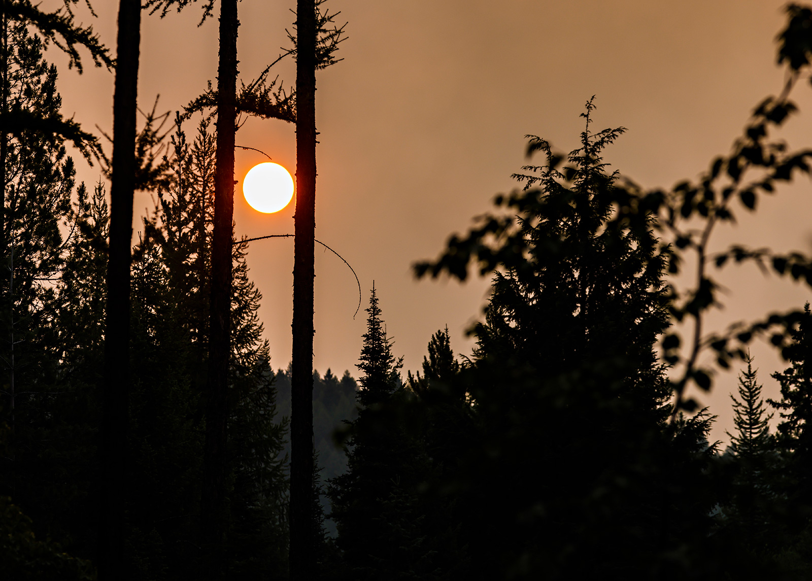
Flathead National Forest officials on Tuesday closed the Hungry Horse Reservoir to all public access as the Ridge Fire to the north and Tin Soldier Complex to the south see continued growth, marking the latest closure as crews work to extinguish a number of wildland fires across northwest Montana.
“The Hungry Horse Reservoir is a very large area with a high level of recreation use with limited emergency egress and fire is now on three sides. While the relatively cooler weather has moderated recent fire growth, hot and dry conditions are forecasted to return and increased wind speeds can cause more active fire behavior. If fire activity were to increase, firefighting personnel and first responders could be diverted from the firefighting effort to facilitating safe public evacuation. The closure is therefore in place to provide for public and firefighter safety,” according to a press release from the national forest.
The Ridge Fire, which is currently burning 2,940 acres near Hungry Horse, has forced the closure numerous campgrounds and forest service roads in the Spotted Bear Ranger District and has threatened property in Coram, Martin City and Hungry Horse. Two interagency hotshot crews arrived on the scene of the fire today, and a Complex Incident Management Team will assume command of the fire tomorrow.
The reopening of the recreation area will be dependent on fire activity, and whether or not firefighting crews are “feeling very confident that the fire won’t spread in the direction of the reservoir,” Flathead National Forest Public Affairs Specialist Kira Powell said.
Law enforcement officials are conducting sweeps of the reservoir on land and water to ensure all visitors are aware of the closures and are able to leave the area.
All recreation sites in the Hungry Horse Reservoir that were reserved on recreation.gov will be automatically refunded.
To the south, weekend precipitation allowed crews to achieve 39% containment of the Colt Fire, a 7,179-acre incident burning near Seeley Lake.
Crews have also contained greater portions of the Niarada Fire, a 20,365-acre fire west of Elmo. There will be two community meetings this week regarding the Niarada, Big Knife and Mill Pocket fires. The meetings will be held at 6 p.m. on Wednesday, Aug. 9 at the Elmo Community Center and Thursday, Aug. 10 at the Arlee Community Center. The meetings will also be broadcast live on the CSKT Division of Fire Facebook page.
Though cooler temperatures and increased humidity helped crews quell some fire incidents over the weekend, forecasts for hot, dry weather in the coming days foreshadow continued fire growth.
“We’re still in Stage 2 fire restrictions,” Powell said, encouraging residents and visitors to comply by existing restrictions and remain aware of the extreme fire risks.
“It’s important that people are aware that our firefighting crews are giving all they’ve got to the fires that we have, and the last thing that we need right now is another start or another few starts from a stove, or a chain, or a spark.”
Please note that the following reflects the latest information received at the time of publication. To see the latest updates for all major wildfires visit inciweb.nwcg.gov.
Major Wildfire Incidents
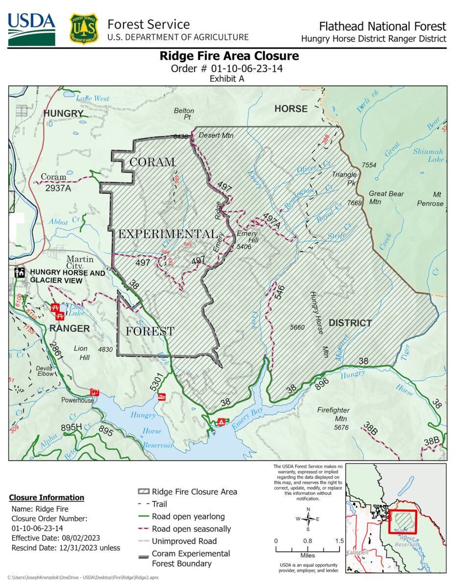
Ridge Fire
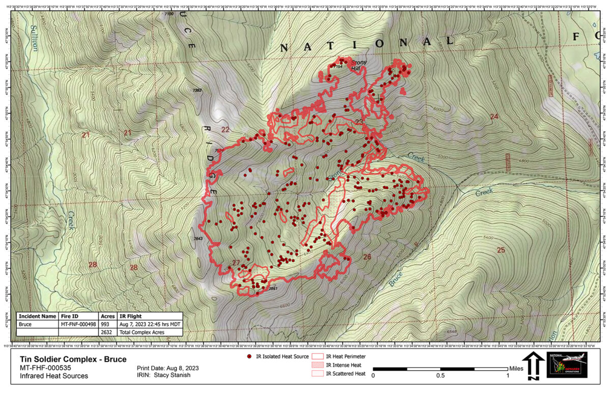
Tin Soldier Complex
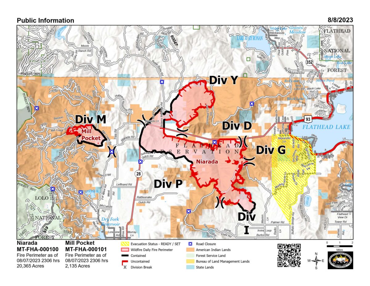
Mill Pocket / Niarada Fire
Big Knife
Colt Fire
East Fork Fire
Ridge Fire
Location: 6 miles southeast of Hungry Horse
Size: 2,940 acres
Containment: 0%
Personnel: 198
Evacuation Warnings/Orders and Road Closures: NFS Road 38, East Side Road, is closed east of the junction of FS Road 497 (Desert Mountain Road) and East Side Road. West Side South Fork Road 895 is closed to all public traffic starting at the Hungry Horse Dam Visitor Center. The road will remain open approximately 800 feet south of the west abutment of Hungry Horse Dam to facilitate traffic flow. Pre-evacuation notice in effect for private property along SF Abbot Creek on the west side of the fire.
Operational Updates: Though multiple crews continue to work on the fire, options to engage the fire have been limited due to heavy vegetation and steep terrain. Heavy equipment will continue implementing the fuel break near the Hard Money Road working north towards Highway 2. Two interagency hotshot crews arrived today and will be opening up existing roads near the East Side Road to assess the fire’s spread. Structure protection assessments will continue for private property in Martin City, Coram and Hungry Horse. A complex incident management team is assuming command of the fire tomorrow, Aug. 9.
Tin Soldier Complex
Location: 17 miles east of Swan Lake
Size: 2,631 acres
Containment: 0%
Personnel: 70
Evacuation Warnings/Orders and Road Closures: The Flathead County Sheriff has issued an evacuation for the Heinrude community. An area closure is in effect for the Hungry Horse Reservoir, the front country of the Spotted Bear district, as well the Gorge Creek drainage within the Bob Marshall Wilderness area, includingFeather, Inspiration, Gorge, Canyon Trickle, and Stadium Creeks. This closure includes NFS Trails #105, #107 and #218.
A temporary flight restriction is in place for air space over the Tin Soldier Complex, including the Spotted Bear and Meadow Creek Airstrips, to provide a safe environment for firefighting aircraft operating in the area.
Tin Soldier Complex Closure:
The closure area encompasses the southern portion of the Hungry Horse Reservoir from the Jewel Basin Hiking Area boundary west of the reservoir to the mountain ridgeline from Prospector Mountain along the Great Bear and Bob Marshall Wilderness boundaries to Inspiration Point in section 4 T23N R16W. The waters of Hungry Horse Reservoir within this boundary are included in the closure area.
All roads and trails within the closure are closed to the public, including two additional trails:
- NFS Trail #7 (Alpine 7) from the junction with NFS Trail #10 (Six Mile Trail), south to the Junction with NFS Trail #31(Napa Point Trail).
- Spotted Bear River Trail #2 from the Wilderness Boundary to its junction with NFS Trail #173 (Pentagon Creek).
NFS Trail #64 and NFS Road 895F are not part of the closure and remain open.
Operational Updates: Fire activity on Monday was minimal in the Tin Soldier Complex, with an increase of 51 acres across the Bruce, Kah Mountain and Sullivan Fires. Fire personnel are continuing structure protection efforts for the Spotted Bear Ranch, Diamond R Ranch and the Spotted Bear Ranger Station compound, and have developed a structure plan for the Heinrude residential community. High temperatures and low humidity through the end of the week may lead to increases in fire behavior and growth.
Mill Pocket / Niarada Fire
Location: 15 / 12 miles west of Elmo
Size: 2,135 acres / 20,365 acres
Containment: 35% / 25%
Personnel: 152
Evacuation Warnings/Orders and Road Closures: The Lake County Sheriff’s Office has downgraded those in EVACUATION status near the Niarada Fire in Lake County to a PRE-EVACUATION WARNING. This area includes Alexander Road, Early Dawn Road, Spring Lane Road, Walking Horse Lane, Windward Heights Road, Wildhorse View, Buffalo Bridge Road, Saddle Drive, Island Butte Lane, Bridle Path, Ten Deuce Way, Cliffview Drive, and Ricketts Road.
A PRE-EVACUATION WARNING means that citizens may return to their homes, however, as there is still a potential threat from the Niarada Fire, they are encouraged not bring back evacuated livestock until the area is downgraded to READY status.
The remainder of the town of Elmo is in READY status.
The Flathead County Sheriff yesterday lifted the evacuation notice on the Niarada Fire from Browns Meadow Pass to Highway 28, including Kofford Ridge Road and Battle Butte Road. The Flathead County Sheriff has also lifted the pre-evacuation warning for the Mill Pocket Fire, Hubbart Dam Rd/NF-544 from the intersection of Crossover Rd South to Highway 28.
Drivers are encouraged to use extreme caution when driving on Highway 28. Authorities reduced speed limits to 45 mph due to poor visibility, and firefighters and equipment are still working in the area
Operational Updates: Conditions around the Niarada Fire are drying out. Firelines around the northern perimeter of the incident continue to hold, and crews have made progress “mopping up” on the fire’s northeastern perimeter along Cromwell Creek. Heavy fuels and steep terrain have continued to hamper efforts along the fire’s eastern and southeastern edge. Structure protection crews are continuing to work outside Elmo towards Big Arm. Firefighters working on the Mill Pocket Fire are continuing to improve constructed firelines, and aerial resources are helping to cool hotspots in the steep scree slopes along the fire’s northwestern edge.
Additional Information: There will be two community meetings this week regarding the Big Knife, Niarada and Mill Pocket fires. The meetings wil be held at 6 p.m. on Wednesday, Aug. 9 at the Elmo Community Center and Thursday, Aug. 10 at the Arlee Community Center. The meetings will also be broadcast live on the CSKT Division of Fire Facebook page.
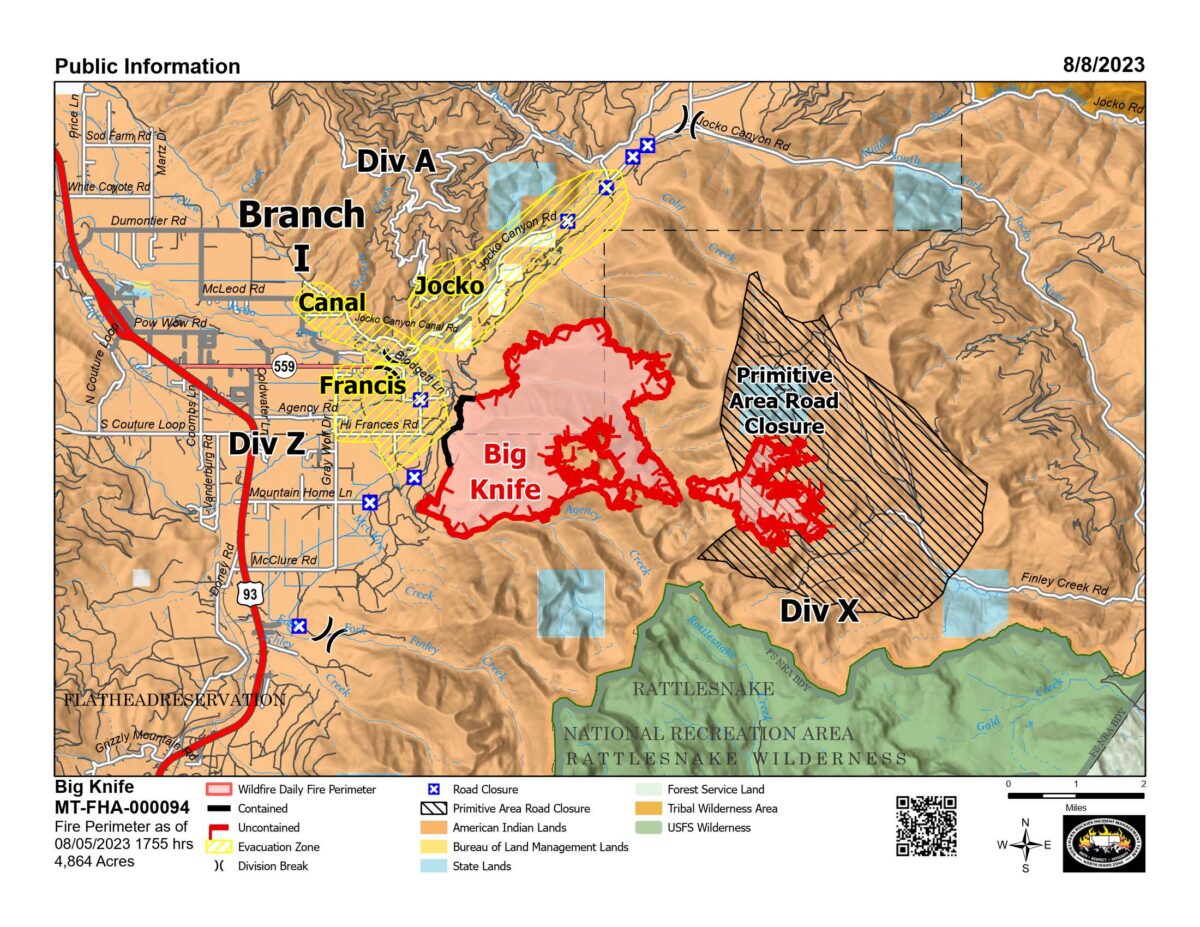
Big Knife
Location: 5 miles east of Arlee
Size: 4,864 acres
Containment: 5%
Personnel: 316
Evacuation Warnings/Orders and Road Closures: The Lake County Sheriff has placed several areas near the base of the mountains west of the Big Knife Fire in PRE-EVACUATION status. See the attached map for specific locations. In the Tribal Primitive Area, Belmore Slough and Burnt Cabin Roads are closed.
Drivers are encouraged to use extreme caution when driving on Highway 28. Authorities reduced speed limits to 45 mph due to poor visibility, and firefighters and equipment are still working in the area
Operational Updates: Though weekend precipitation and cool temperatures reduced fire behavior, a warming and drying trend returned to the Big Knife Fire on Monday. Heavy equipment operators completed a mastication line along the fire’s southwestern edge to reduce fuels. Crews are assessing and implementing point protection measures and are mulching vegetation along Jocko Canyon and Canal roads. Firefighters are continuing to hold, improve and “mop up” the edge of a strategic firing operation to keep the fire north of Agency Creek. Resource Advisors are working with fire managers to ensure cultural and natural resource values are evaluated and protected during suppression activities.
Additional Information: There will be two community meetings this week regarding the Big Knife, Niarada and Mill Pocket fires. The meetings wil be held at 6 p.m. on Wednesday, Aug. 9 at the Elmo Community Center and Thursday, Aug. 10 at the Arlee Community Center. The meetings will also be broadcast live on the CSKT Division of Fire Facebook page.
Colt Fire
Location: 15 miles northwest of Seeley Lake
Size: 7,179 acres
Containment: 39%
Personnel: 506
Evacuation Warnings/Orders and Road Closures: There are currently no evacuations issued for this incident. Up-to-date evacuation information can be found on the Missoula County Sheriff’s Office Facebook page.
While Highway 83 is currently open, drivers are urged not to stop along Highway 83. Due to fire activity and smoke across the roadway, visibility is impaired, and traffic is increased, including emergency response vehicles, large equipment and law enforcement.
Air operations will be using two unmanned aerial systems (UAS “drones”) in the coming days to map out areas of heat. The UAS aircraft is best able to pick up areas of heat within the fire late at night and early in the morning due to lower air temperatures at these times. For this reason, the temporary flight restriction (TFR) for the fire area (FDC 3/7867) has been extended from 8am-10am to a full 24-hour restriction in order to provide a safe environment for firefighting aircraft operating in the area.
Operational Updates: Crews were able to successfully bring the containment of the Colt Fire to 39% as they took advantage of quieted fire behavior from recent moisture. Yesterday’s drier weather allowed crews to successfully access the southern edge of the fire to construct a line. Crews will continue to “mop up” residual heat along the fire’s northern and eastern edges between Colt Lake and Beaver Lake, and will continue constructing line west to Sunset Ridge on the south flank.
East Fork Fire
Location: 12 miles south of Trego
Size: 1,376 acres
Containment: 6%
Personnel: 130
Evacuation Warnings/Orders and Road Closures: There are no closures in place at this time, however citizens are encouraged to avoid the area and give fire personnel room to work.
Operational Updates: The East Fork Fire received precipitation yesterday and has experienced minimal growth over the past two days. Crews are utilizing cooler and wetter weather conditions to carry out more direct suppression efforts. An indirect containment line has now been constructed around the entire fire, including direct line in some areas. Resources will continue to monitor fire behavior with aircraft while equipment continues to establish an anchor and construct lines around the fire. This includes flanking the dire from the east side and along Road #3530 from west to east.