Flathead National Forest Conducts Spring Prescribed Burn Projects
Smoke was visible from various places in the Flathead Valley depending on the location and weather conditions
By Beacon Staff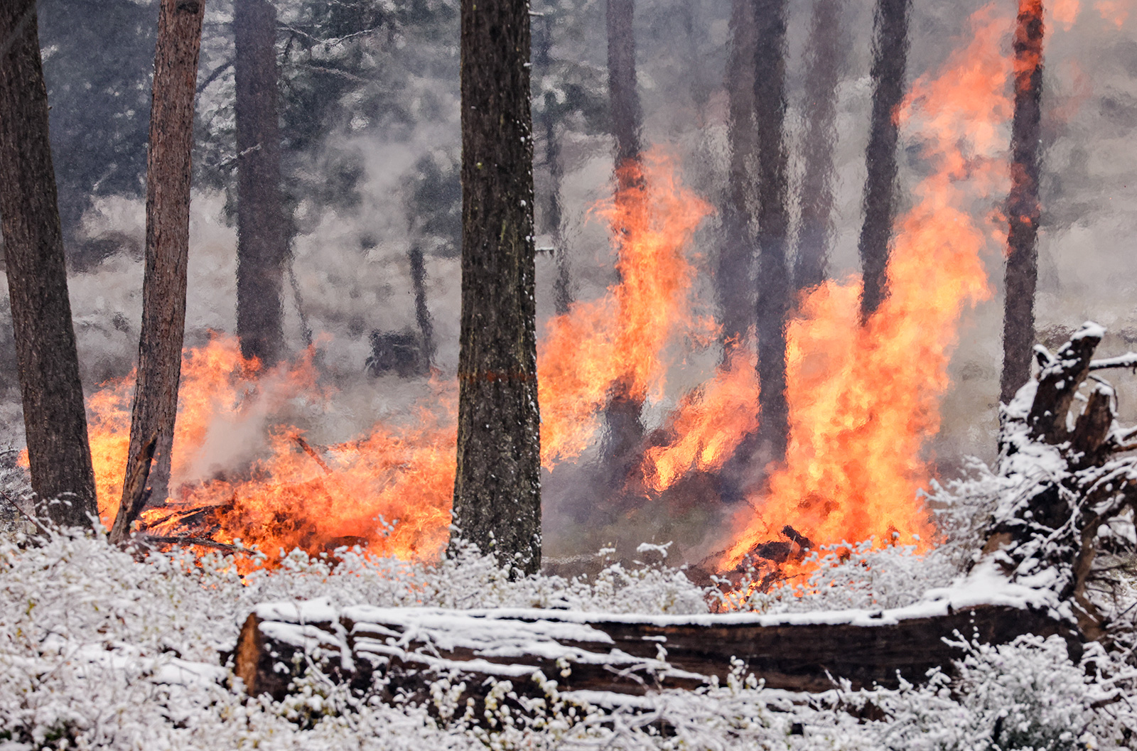
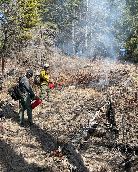
Fuels managers and firefighters with the Flathead National Forest conducted spring prescribed fire projects across its four districts this week during a window of favorable weather, good fuel conditions and clear air quality. Smoke was visible from various vantage points in the Flathead Valley depending on the location of the burn units and weather conditions.
“During this round, prescribed fire was introduced to units across the forest to further prep them for the planting of baby trees and to mitigate future wildfire risk,” according to Flathead National Forest officials. “The recent warm weather presented a unique opportunity where a window opened for prescribed burning in areas where snow is still on the ground.”
Each fire project followed a prescribed burn plan, according to agency officials, which reduced the potential for adverse effects, such as an escaped wildland fire.
The projects followed Montana air quality standards coordinated with the Department of Environmental Quality (DEQ) to reduce the impacts of smoke to neighbors, cooperators, and surrounding communities, according to a Flathead National Forest press release announcing the projects, which are described below.
For additional information about the prescribed fire ignitions visit the Flathead National Forest Facebook page.
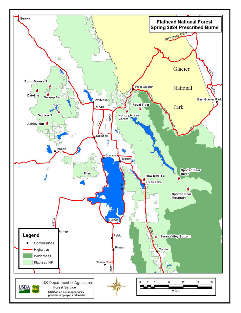
The project areas include:
Swan Lake Ranger District
How Now Timber Sale – This project north of Swan Lake included broadcast burning in timber harvest units located on Sixmile Mountain. These treatments used prescribed fire for fuels reduction and vegetation regeneration.
Swan Valley Bottom Maintenance Burning – This project entailed maintenance broadcast burning in previously treated timber harvest units located within the Swan Valley. The treatments used prescribed fire for fuels reduction, large ungulate winter range improvement and improvement of forest health.
Swan Lake Ranger Station – This project included under-burning the administrative site at the Swan Lake Ranger District office located in Bigfork. The purpose of this treatment was aimed at fuels reduction.
Pile Burning – Hand or machine piles located near Blacktail Mountain, the Swan Valley and Bigfork, as well as miscellaneous piles around the district. These piles were burned to reduce fuel loads.
Tally Lake Ranger District
Dateline 79/80, Swamp Rat 6, Salish Good GNA 67 – These burns across 118 acres were engineered to reduce timber harvest activity fuel loads, improve forest stand conditions, improve and maintain terrestrial wildlife habitat, and help with site preparation for regeneration of forest stands that are more fire resilient.
Oettiker 3 – This 96-acre unit is in the vicinity of Star Meadow, approximately 14 air miles west of Whitefish, and was previously burned in the spring of 2016. The intent of this “maintenance burning” was to consume the dead fuel created from the initial 2016 prescribed fire. Big game use the area as winter range, so the prescribed fire not only reduced fuel loading in the wildland urban interface but also enhanced winter range by increasing the amount of browse to big game for winter forage.
Burnt Grouse 2.0 – This 220-acre unit is in the Good Creek drainage approximately seven air miles southwest of Olney and was previously burned in the fall of 2014. The area is big game winter range with partial funding provided in partnership with the Rocky Mountain Elk Foundation. The prescribed fire should help reduce fuel loading in the wildland urban interface created from the 2014 prescribed fire and will also enhance winter range by increasing the amount of browse to big game for winter forage.
Ashley Mtn 202 – Prescribed fire burned approximately 200 acres of natural fuels to reduce the likelihood of crown fire, reduce stand density, and improve mule deer and elk habitat. The prescribed fire will also help protect the agency’s Ashley Mountain communication site from future fire. The burn will be highly visible from the Ashley Lake area.
Pile Bruning – Entailed burning small hand piles in the Bootjack Lake and Pilot Knob area. These piles were burned to reduce fuel loads in these areas.
Hungry Horse/Glacier View Districts
Royal Tiger Units 54/54A/55/57 – These units are in the Emery Creek Drainage on the east side of the Hungry Horse Reservoir. Utilizing hand ignitions to burn 115 acres on steep slopes, the objective was to conduct a low-intensity prescribed burn to achieve multiple objectives: reduce fire hazard, prepare the site for regeneration and create a more diverse mosaic of vegetation conditions.
Royal Tiger Unit 86 – This unit is adjacent to Emery Bay on the east side of the Hungry Horse Reservoir. Utilizing hand ignitions to burn 16.3 acres from a shelterwood harvest in 2021, the objectives were to reduce downed fuel load to minimize wildfire hazards and prepare site for natural seed regeneration create a more diverse mosaic if vegetation conditions.
Coram Pasture – Utilized hand ignitions to burn Fields 4, 5, 6, 7, and 8 for a total of 50 acres. Coram Pasture is approximately one mile northeast of Martin City. Coram Pasture is an administrative site used for pasturing agency livestock. Objectives were to improve range by returning fire and the burning of the pastures in the spring will help remove dead residual forage, reduce brush and saplings, and rejuvenate the desirable grass and forage species for greater stock utilization.
Hungry Horse Ranger Station – Utilized hand ignitions to burn four units that are 3.5 acres. These units are located on the Ranger Station Administrative site. The objective is to remove fuel loadings and reduce risk to compound residences should a fire occur. Introduce fire into Aspen stands to restore and stimulate natural conditions.
Spotted Bear Ranger District
Spotted Bear River units E, M, and N – Hand and aerial ignition (unmanned aircraft system) was utilized to blackline approximately 100 acres of Spotted Bear River units E, M, and N in order create a buffer for burning the rest of these units as well as adjacent units 50, 65, 66 and Silver Mule 48, & 49. The units are located on the south end of Horse Ridge near the Spotted Bear Ranger Station. They are being burned to reduce fuel loading, maintain and increase winter range forage, and reintroduce fire into the ecosystem. The units are a mix of grassy openings, shrub fields, and timber patches. In the absence of fire since 1929, conifer encroachment into the shrub fields and grassy openings has begun to reduce the available forage in this area. The low to moderate intensity prescribed fire is intended to push back the conifer encroachment while retaining key thermal cover timber patches.
Spotted Bear Mountain Unit 300 – Utilizing hand and aerial ignition (UAS), a prescribed fire unit in the new Spotted Bear Mountain timber sale was burned in conjunction with a timber harvest unit (Silver Mule unit 71) for a total of 48 acres. The units are located to the southeast of the Spotted Bear Ranger Station, just south of Spotted Bear Lake.
For more information about these projects, contact the appropriate Ranger Station:
Hungry Horse/Glacier View Ranger District: (406) 387-3800
Tally Lake Ranger District: (406) 758-5204
Swan Lake Ranger District: (406) 837-7500
Spotted Bear Ranger District: (406) 758-5376