Two Decades of Railway Avalanche Safety
Since launching in 2005, the BNSF Avalanche Safety Program has helped significantly reduce train derailments caused by avalanches in John F. Stevens Canyon along the transportation corridor adjacent to the Middle Fork of the Flathead River
By Maggie Dresser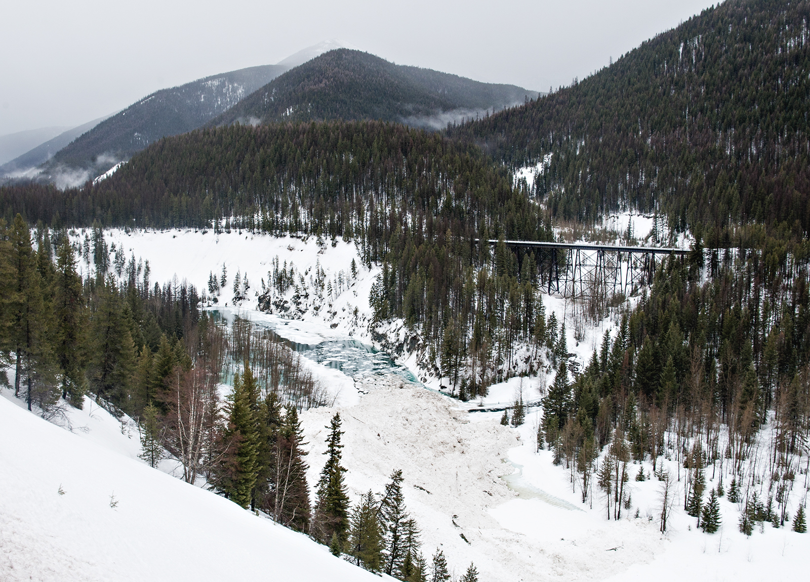
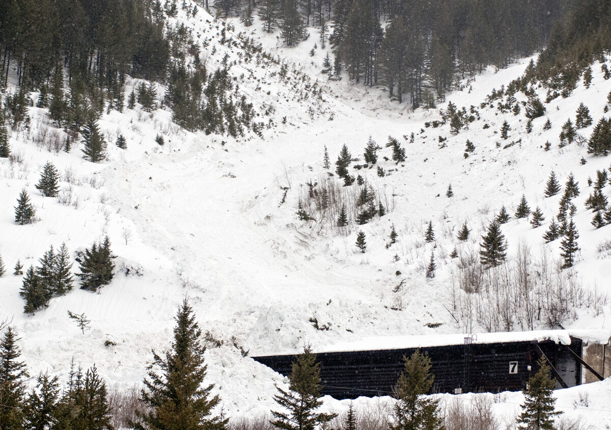
On Jan. 28, 2004, a freight train hauling 119 empty grain cars and three locomotives was traveling from Pasco, Wash. to Great Falls when two avalanches near Essex and Glacier National Park struck the Burlington Northern Sante Fe (BNSF) Railway twice within 15 minutes. The slides derailed the train, knocking 15 cars off the rails and resulted in the closure of the tracks. If the slides occurred 71 minutes later, the avalanches may have collided with Amtrak’s Empire Builder passenger train that uses the same route.
In the aftermath, the railway was shut down for 29 hours amid unsafe avalanche conditions. As crews shoveled snow off the tracks and cleaned up the mess left over from the derailment, BNSF officials began formulating a plan to prevent more incidents like it from happening in the future.
Railway officials began working with Dave Hamre, an Alaska-based avalanche mitigation expert specializing in infrastructure projects, and Ted Steiner, a Flathead Valley avalanche professional. The following year, Dave Hamre and Associates, LLC contracted with the railway and the BNSF Avalanche Safety Program launched.
That year, Hamre worked with the railway, the Montana Department of Transportation (MDT) and the National Park Service to formulate an avalanche mitigation plan that included the creation of an avalanche atlas, the compilation of historic records and the construction of several new snow sheds.
“It was the 2004 avalanche incident on the railway that really got them interested in trying to improve avalanche safety,” BNSF Avalanche Program Assistant Manager Ted Steiner said during a January presentation hosted by the nonprofit Flathead Lakers at the Flathead Lake Brewing Company in Bigfork.

Situated between the Great Bear Wilderness and Glacier National Park, the corridor along U.S. Highway 2 and the Middle Fork of the Flathead River known as “Avalanche Alley” has been wreaking havoc on the travel corridor since the Great Northern Railway Company completed the rail line in 1893 before it was acquired by BNSF.
Avalanche activity has specifically affected John F. Stevens Canyon from west of Essex to the Continental Divide, causing 18 fatalities between 1889 and 1929.
Steiner says significant avalanche cycles in John F. Stevens Canyon are typically caused by what weather forecasters describe as an “overrunning Arctic air event” when cold air entrenched in valleys collides with moisture.
“That cold air might be 20 degrees below zero and maybe a little warmer up high and once that cold air is entrenched and Pacific moisture that starts bumping into or overriding that Arctic air, the dew point is hit and all of that moisture is drawn out,” Steiner said. “When this happens – because the air is so cold to start – we have a lot of low-density snowfall that happens at a heavy rate. It’s not uncommon to see feet of snow in this particular situation.”
“That’s usually when we’re seeing our really large avalanches happening – it’s during these overrunning events,” Steiner added.
To clean up avalanche debris resulting from these cycles, “track walkers” would shovel snow off the tracks during the first few decades of operation, working out of shanty towns along the railway known as Java, Singleshot and Highgate. While the towns are long abandoned, their names still exist on maps today.
“All these towns are gone now, but they were important to the railway back in the day for clearing avalanche debris out of the rail grade so that rail traffic wouldn’t be late,” Steiner said.
Snow sheds were constructed in the canyon during the early operating years, which consist of protective structures with sloped roofs to prevent snow from hitting the tracks, and additionl sheds were added when the avalanche program launched more than a century later. Today, BNSF has 17 active snow sheds, 10 of which run from Montana’s Hi-Line east of the Continental Divide through John F. Stevens Canyon. The remaining seven exist in Washington’s Cascade Mountains.
While avalanche danger is present every winter, Steiner said 1957 was a particularly bad year that destroyed Shed 11 and caused the railway to shut down for weeks. The Izaak Walton Inn in Essex was transformed into an emergency command center during this period.
On Feb. 13, 1979, multiple slides carried a 160-foot bridge at the Goat Lick turnout 200 feet into the Middle Fork of the Flathead River. The destruction closed U.S. Highway 2 for a month and severed the main route between Kalispell and Great Falls. At the time, a daily average of 714 vehicles utilized the stretch of road and travelers were instead rerouted south on Montana Highway 200 through the Swan Valley to Helena. The railway rerouted traffic from Havre to Helena, Missoula or Sandpoint, Idaho, according to newspaper archives.

On March 5, 2014, three avalanches in the canyon caused the closure of the highway along with the railway, prompting BNSF to obtain a special-use permit from Glacier National Park to trigger avalanches using explosives – a practice that is not typically allowed in the region because of its protected status. One of the largest slides triggered above the Goat Lick Overlook – the same slide path that destroyed the bridge decades earlier.
During periods of dangerous avalanche cycles, BNSF sometimes receives emergency authorization to conduct avalanche mitigation work, which was the case in 2014 when avalanche experts used pentolite – an explosive charge that’s delivered out of a helicopter.
Officials also sometimes use a DaisyBell™, a gas explosive device that is comprised of an 8-foot-tall metal cone that uses a mix of oxygen and hydrogen gases and a sophisticated ignition system. The device directs an explosive blast down onto the snowpack and is hung on a long line attached to a helicopter. An operator sits at the back door of the helicopter and directs the pilot to different shot points and operates the bell with a radio controller, according to BNSF Avalanche Safety Program Manager Adam Clark.
“The DaisyBell™ can deliver more shots in a shorter amount of time when compared to deploying explosive charges,” Clark said in an email. “[It’s] great for programs that can mitigate regularly, which is not always the case at BNSF Avalanche Safety. The problem is that the forces applied to the snowpack from gas exploders are not as great as those from explosive charges like pentolite or ANFO. So, if we are trying to determine sensitivity of a potentially dangerous old, buried weak layer under a hard slab of snow – which is often the case above the rail – explosives are often a better tool.”
Over the last 20 years, emergency mitigation work has been requested six different times: in February 2006; December 2008; March 2014; February 2017; February 2018; and, most recently, in February 2021.
In the program’s early days, Hamre, the original consultant for BNSF, advocated for the regular use of explosives and “avalaunchers” for avalanche mitigation, which are widely used across the West in places like Utah and Colorado. But since most avalanche start zones begin in Glacier National Park, the Park Service and the U.S. Department of the Interior in 2008 denied the use of explosives except in emergency situations following a lengthy environmental assessment.
“What ended up happening is that explosives would not be permitted unless there were extenuating emergency circumstances and only after the railway had taken all other necessary actions to avoid avalanches,” Steiner said.

Two decades after the BNSF Avalanche Program launched, avalanche forecasters continue to work out of a trailer at its Essex headquarters near the Izaak Walton Inn and the train depot.
After helping found the program with Hamre, Steiner worked as the program’s manager until 2018 when he stepped down to the assistant position. Mark Dundas, who currently works as the lead forecaster for the Flathead Avalanche Center, worked for BNSF until the winter of 2014-2015 when Clark replaced him.
After Steiner passed the torch in 2018, Clark is now responsible for managing the program’s avalanche forecasting, education and hazard mitigation in John F. Stevens Canyon.
Forecasters start out each season with a meeting among stakeholders that includes officials with MDT, Flathead National Forest, National Park Service and other emergency management partners.
When Clark and Steiner aren’t at the headquarters in Essex, they are often conducting field work at various avalanche paths and collecting data from snow-pit profiles and study plots.
“We’ve been maintaining these [plots] now for 20 years and we have quite a bit of manual weather observation data,” Steiner said. “This helps us keep track of the weather in terms of snow depth and snow accumulation throughout each season.”
Unlike the Flathead Avalanche Center, which forecasts hazards based on a scale designed to aid recreationists — with “low,” “moderate,” “considerable,” and “high” ratings — the BNSF program’s forecasting matrix involves a scoring formula. Depending on the score, each forecast is categorized in five levels known as the Railroad Avalanche Danger Scale (RADS), which was developed by Steiner and is specific to the railway. It applies only to avalanche paths that threaten the rail at rail grade elevations.
“There are recommended restrictions that are advised from level two through five on this avalanche danger scale with the idea being that we’re reducing the exposure and consequences of any avalanche activity that may occur for railway elements at risk,” Steiner said.
In the last 25 years, BNSF derailments have reduced by more than 60%, which is largely due to the avalanche program since its launch two decades ago.
“We’re in a very important transportation corridor and we do what we can to assist in keeping it open,” Steiner said.