With Drought on Tap for Montana Rivers and Streams, Top Fisheries Official Warns ‘It’s Going to Be A Rough One’
Warm temperatures and depressed flows typical of mid-July are already affecting Montana’s river basins, setting the stage for a summer of angling restrictions and ecological stressors
By Tristan Scott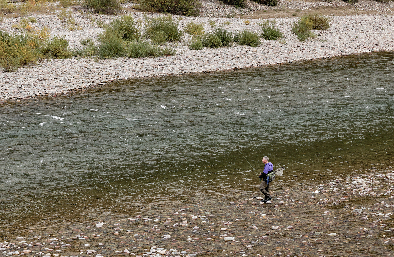
Stream gage data is already registering temperatures and flows that normally don’t bedevil Montana’s rivers and tributaries until mid-July, prompting state fisheries managers to issue early warning signals on Wednesday that anglers should anticipate restrictions and closures this summer.
From the Rocky Mountain Front to the Flathead River Basin, the high-elevation snowpack that nourishes rivers through the dry months of summer is on track to be depleted ahead of schedule, with spring runoff having already peaked across much of Montana. It’s the fifth consecutive season that drought conditions have beset Montana’s waterbodies. Meanwhile, other early-season indicators predict severe drought conditions that will almost certainly trigger management actions, including closures and “hoot owl” restrictions that prohibit angling during the heat of the day.
“What that means to us as far as a prognosis is … if it’s like mid-July right now, we’re possibly going to be talking about hoot owl restrictions in the coming weeks. So It’s a bit alarming,” said Patrick Saffel, the fisheries manager for Montana Fish, Wildlife and Parks’ (FWP) Region 2 office, which includes the entire Clark Fork and Blackfoot rivers, where flows are currently at about one-third of the volume they were at the same time last year.
At a virtual town hall on Wednesday, FWP’s regional biologists joined the state’s fisheries chief, Adam Strainer, to assess the situation on the heels of a June water supply outlook that painted a grim picture for most of Montana’s river basins.
“Our decisions impact anglers as they game out their fishing plans for the summer and fall months so it’s important for everyone to understand why we might close a river for a portion of a day or ask an irrigator to restrict use,” Strainer said at the top of the panel discussion before acknowledging that “it’s going to be a rough one this summer.”
Currently, all three forks of the Flathead River are running at between 30% and 40% below the long-term average, while the snowpack for the Flathead basin is about 70% of average. On the North Fork Flathead River, where fisheries managers in July 2024 took the unprecedented step of imposing angling restrictions along the western border of Glacier National Park, stream flows are more than a foot below (5.08 feet) where they were this time last year (6.18 feet). The current discharge is 5,980 cubic feet per second (cfs), compared to a discharge rate of 9,000 cfs at this time last year, and well below the median rate of 10,400 cfs.
The mid-day temperature of 53.4 degrees Fahrenheit recorded on the North Fork on June 11 is also warmer than it was on the same day last year, when the stream temperature was 48.9 degrees.
“So, we are anticipating another year of low flows unless something changes,” Leo Rosenthal, the fisheries management biologists for FWP’s Region 1, said. “We will be monitoring temperature and flow in all three forks as the summer progresses to see if any restrictions need to be initiated.”
FWP’s Statewide Fisheries Management Plan identifies temperature criteria for westslope cutthroat trout that trigger restrictions when water temperatures reach or exceed 66 degrees Fahrenheit for three consecutive days. The criteria for bull trout on the South Fork Flathead River, which is the only river in which FWP manages a catch-and-release fishery for bull trout, is 60 degrees, also for three consecutive days.
Angling restriction on most Montana streams with rainbow and brown trout are triggered when water temperature reaches 73 degrees for three consecutive days; however, there are other exceptions to the standard if officials need to mitigate “extreme angling pressure.”
The Flathead watershed has historically avoided hoot owl restrictions due to its geography and geology; not only are the rivers fed by higher-elevation tributaries that come out of the mountains and stay cold even at lower flows, but they’re also more influenced by the groundwater. Last year, however, water temperatures shattered records and streams across the region by July 22, when U.S. Geological Survey stream gages on the North Fork near Glacier Rim Fishing Access Site registered a record-high daily temperature of 66.92 degrees Fahrenheit, marking the third consecutive day that water temperatures exceeded a 66-degree threshold that biologists say is stressful to native westslope cutthroat trout. Later that day, the temperatures hit 67.82 degrees Fahrenheit.
According to the U.S. Drought Monitor, the conditions are even worse along the Rocky Mountain Front, where severe drought conditions are likely to impact fisheries as well as irrigators who rely on the Dearborn, Sun and Marias rivers. Meanwhile, reservoirs in the drainage weren’t able to fill before irrigation withdrawals began.
On the heavily irrigated Sun River, for example, the discharge rate is currently 107 cfs compared to a median flow of 1,400 cfs for this time of year.
The Dearborn River, which is popular for floaters due to its normally high flows in June, is currently running at 63 cfs, the lowest flows on record in 55 years of data collection. The previous record low on the Dearborn occurred in 2000, which was “a memorable drought year,” according to Jason Mullen, FWP’s fisheries manager for Region 4 based in Great Falls.
“And we are more than half below what we saw in 2000,” Mullen said. “So, very low flows there.”
At Gibson Reservoir, an impoundment of the Sun River located south of the Bob Marshall Wilderness Area near Augusta, the reservoir is at 71% of full pool, and was still 17 feet below its maximum capacity when it peaked this spring. It’s the second consecutive year the reservoir hasn’t filled, Mullen said. Prior to that, the last time it didn’t fill was in the 1940s.
Willow Reservoir, the other reservoir in the Sun River drainage, is 65% full and dropping, having already peaked at about 8 feet below capacity.
“So, in general, rivers and reservoirs along the Rocky Mountain Front are in really poor condition,” Mullen said. “This is obviously not good for fisheries, not good for trout recruitment. I do want to note that most boat ramps are accessible now, but we should expect that many of the boat ramps at reservoirs will no longer be accessible by July.”
As extreme drought becomes more frequent and severe, posing threats to freshwater ecosystems and the critical services they provide, scientists at the U.S. Geological Survey (USGS) Northern Rocky Mountain Science Center (NOROCK) and Montana State University are developing Drought Early Warning Systems (DEWS) to help state, federal, and tribal resource managers better understand and manage drought risks to cold-water fisheries. By combining biological, hydrological, and climate data, these systems offer a comprehensive view of how drought impacts freshwater ecosystems, particularly trout habitats.
“By integrating biological, hydrological, and climate data, DEWS provide real-time drought forecasts and long-term insights into how water management impacts fish populations and freshwater habitats,” according to USGS, which provides state fisheries managers with stream flow and temperature data that informs management decisions and policies. “This enables proactive decision-making to protect fish, water resources, and human communities.”