Flathead National Forest Authorizes Logging Project West of Hungry Horse Reservoir
The project involves timber harvests, prescribed burning and whitebark pine restoration on 7,704 acres along the Hungry Horse Reservoir’s western edge, including in core grizzly bear habitat and portions of the Jewel Basin Hiking Area
By Tristan Scott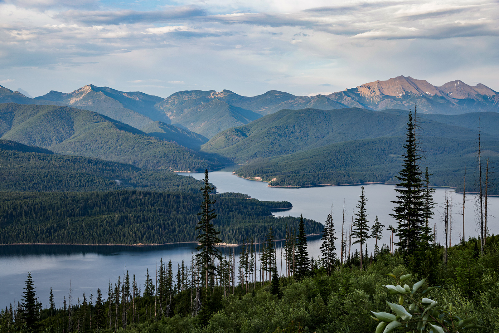
The Flathead National Forest has authorized a project to log portions of a nearly 130,000-acre expanse of federal land west of Hungry Horse Reservoir, including 2,000 acres of commercial harvests in developed areas with a high risk of wildfire. The project also involves work to improve whitebark pine in a recommended wilderness area encompassing the Jewel Basin Hiking Area, as well as prescribed burning in core grizzly bear habitat.
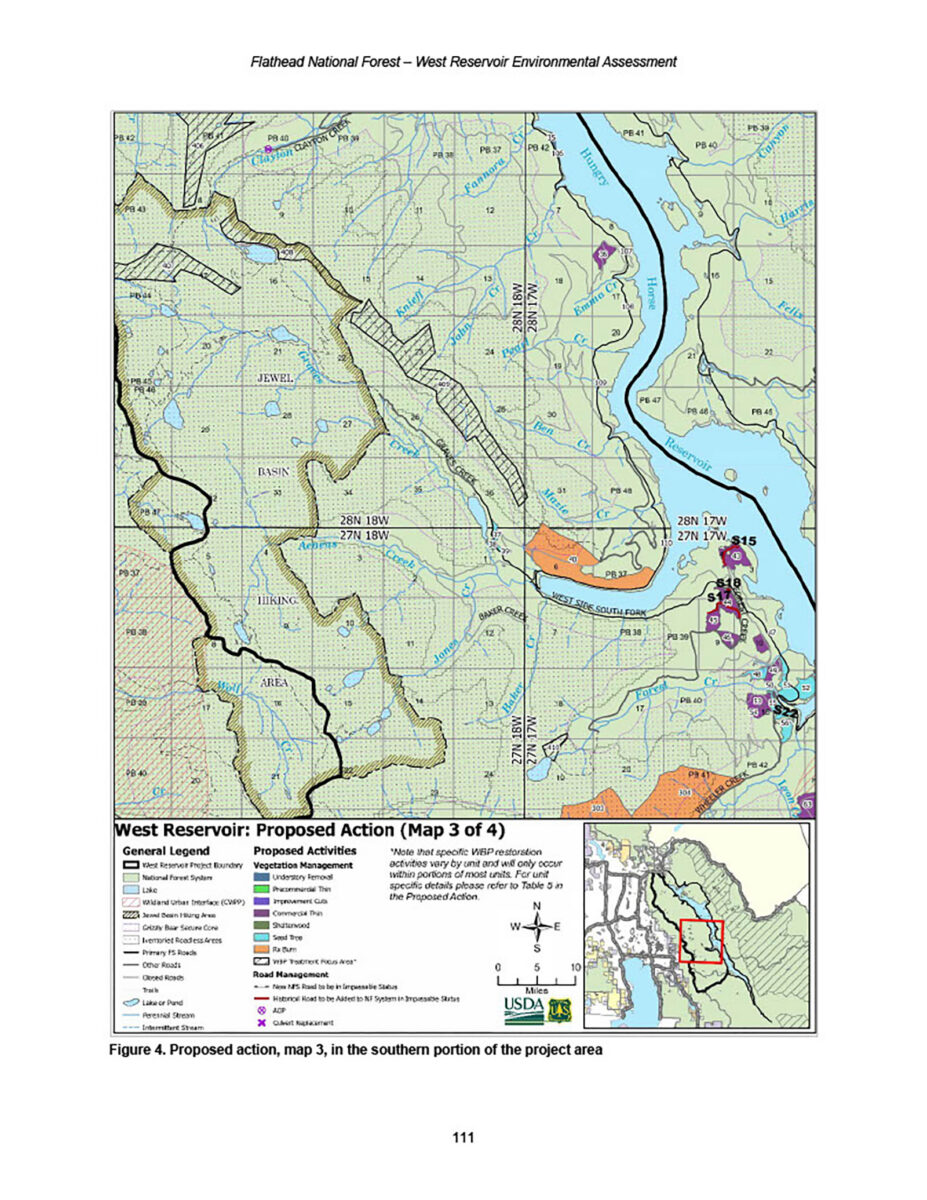
About 7,380 acres of the project area are in the wildland-urban interface (WUI) established by the Flathead County Community Wildfire Protection Plan. The project includes a grand total of 7,704 acres slotted for a range of vegetation treatment beginning this summer. It would add 4.7 miles of new roads (3.1 miles of new construction and 1.6 miles using a historic template) and would replace four culverts.
The project area is located on the Flathead National Forest’s Hungry Horse and Spotted Bear ranger districts. Agency officials on March 12 issued a final decision notice and finding of no significant impact approving the project.
“This project would reduce wildland fire risk to communities, reduce hazardous fuels to lower the risk of wildfire and help make wildfire response safer and more effective, and improve the diversity and resilience of terrestrial ecosystems and vegetation,” Flathead National Forest Supervisor Anthony Botello said in a cover letter accompanying the agency’s environmental assessment of what’s been dubbed the West Reservoir project.
The project involves commercial timber harvest on about 2,000 acres and noncommercial vegetation treatments, including 4,654 acres of prescribed fire and 873 acres of whitebark pine restoration, on about 5,700 acres. Public motorized access would not change.
“Some of the main goals for this project are to improve the health of our forest, increase ungulate forage, improve fish passage at a couple key locations, and move towards restoring whitebark pine,” Hungry Horse-Glacier District Ranger Rob Davies said in January 2025 when the agency first proposed it.
The construction of new roads in grizzly bear habitat was a sticking point for critics, including Keith Hammer of the Swan View Coalition. In comments Hammer submitted to Flathead National Forest officials, he said the project does not comply with a federal judge’s findings that the agency’s standard for reclaiming roads provides insufficient safeguards for grizzly bears and bull trout.
Whether a logging road has been “reclaimed” or merely rendered “impassable” is central to litigation that Hammer helped bring against federal agencies in April 2019 when Swan View Coalition sued the U.S. Fish and Wildlife Service and the Flathead National Forest over the road-building provision in its current forest plan. In 1995, forest officials adopted changes to the plan called Amendment 19, which required the Flathead National Forest “reclaim” any road it wanted to delete from its total motorized route density (TMRD) calculations. In 2018, the Flathead National Forest replaced Amendment 19’s “reclaimed” road standard with an “impassable” road standard.
Under the revised plan, impassable roads no longer count toward total road density if the road — generally the first 50 to 300 feet — has been treated to make it inaccessible to wheeled vehicles during the bear’s non-denning season.
“You propose to build and rebuild 4.7 miles of road, add them to the [National Forest System] road system, then simply render them ‘impassable’ to motor vehicles per the Forest Plan,” Hammer wrote. “This means those roads will not be included in Total Road Density even though they have not been fully reclaimed, have continuing impacts to grizzly bears and remain vulnerable to motorized trespass. This is in violation of the law and numerous rulings by the U.S. District Court in Missoula.”
The author of those rulings, U.S. District Judge Dana Christensen, acknowledged that the ongoing chronic problem of ineffective road closures and unauthorized motorized access can negatively impact grizzly bears. But he stopped short of prohibiting approval of any future timber projects under the revised plan as currently written.
Still, Hammer said the West Reservoir project makes no mention of Christensen’s order to revise the forest plan’s biological opinion pertaining to road removal.
“The Forest Service appears to be trying to move ahead with more logging and new road building without firstly complying with the District Court’s orders against its Forest Plan and Biological Opinion,” Hammer said.
The Flathead National Forest’s environmental assessment of the West Reservoir project, which will occur in the Northern Continental Divide Ecosystem (NCDE) Grizzly Bear Recovery Area, does consider the effects on grizzly bears and other threatened or endangered species, including bull trout, Canada lynx and wolverines. It acknowledges that project activities have “the potential to disturb grizzly bears” and “would temporarily reduce hiding cover” by about 361 acres.
Estimating that the length of time for all project activities is about 10 years, the environmental assessment considers effects on grizzly bears extending 20 years into the future and finds that “hiding cover in the form of dense shrubs and trees able to hide a bear should return in the most-intensively harvested units within that time.”
“Hiding cover could take up to 20 years to return after treatment, depending on stand conditions,” according to the environmental assessment. “Hiding cover would remain well distributed with proposed regeneration treatment.”
“Disturbance effects due to project activities are expected to be temporary, with pulses of motorized activity that occur in different parts of the project subunits at different times, leaving adequate areas of security for grizzly bears available in each affected subunit,” the environmental assessment continues.
Approximately 12% (15,887 acres) of the project area is located within the Jewel Basin recommended wilderness area, a designation that instructs land managers to preserve opportunities on the landscape for inclusion in the National Wilderness Preservation System. Recommended wilderness areas are characterized by a natural environment “where ecological processes such as natural succession, wildfire, avalanches, insects, and disease function with a limited amount of human influence,” according to the Flathead National Forest.
For example, the Jewel Basin hiking area portion of the Jewel Basin recommended wilderness area provides a recreation experience without motorized, mechanical transport or stock use.
Approximately 51% (65,704 acres) of the project area is located within an inventoried roadless area. Management of these lands must comply with the forest plan and the provisions of the 2001 Roadless Conservation Rule.
Two eligible wild and scenic rivers are also in the project area: Aeneas Creek and Graves Creek in the Jewel Basin Hiking Area. The project includes timber harvest on 25 acres in the river corridor of the scenic segment of Graves Creek, while up to an acre of prescribed fire could occur in the river corridor of Aeneas Creek.