Traveling down the Seeley-Swan corridor, swathed in deep forests held in the straight-armed embrace of the rugged Swan Mountains to the east and the Missions to the west, there is another element that dominates the landscape. Wetlands, creeks, rivers, ponds and hundreds of lakes scattered from valley floor to high mountain basins. Water, water, everywhere.
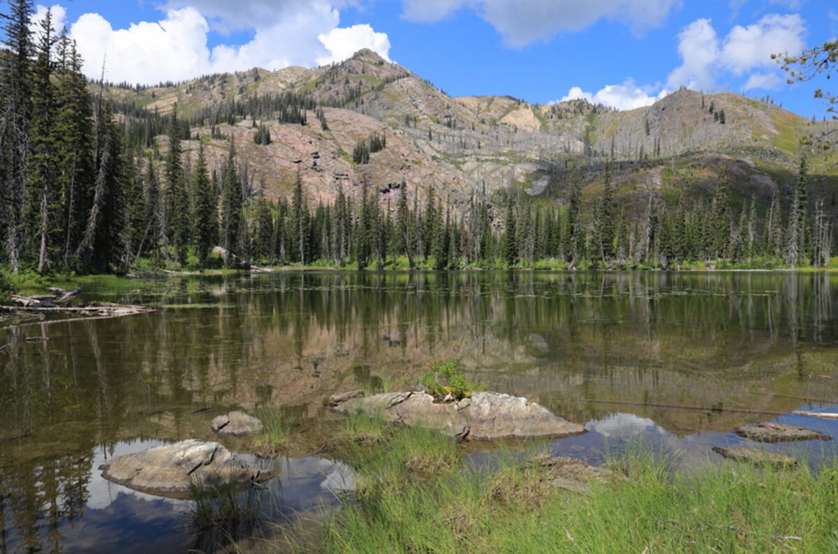
The Swan Valley is the wettest watershed in Montana with 4,000 pot holes, ponds, lakes, marshes and wetlands and a 1,300-mile network of streams that carry water throughout the lush valley. You will spot Swan, Summit and Salmon lakes along the highway, and others such as Holland and Lindbergh are just a few miles away from the thoroughfare. Farther south, the Clearwater Valley is marked by a chain of lakes — Rainy, Inez, Alva, Seeley and Salmon.
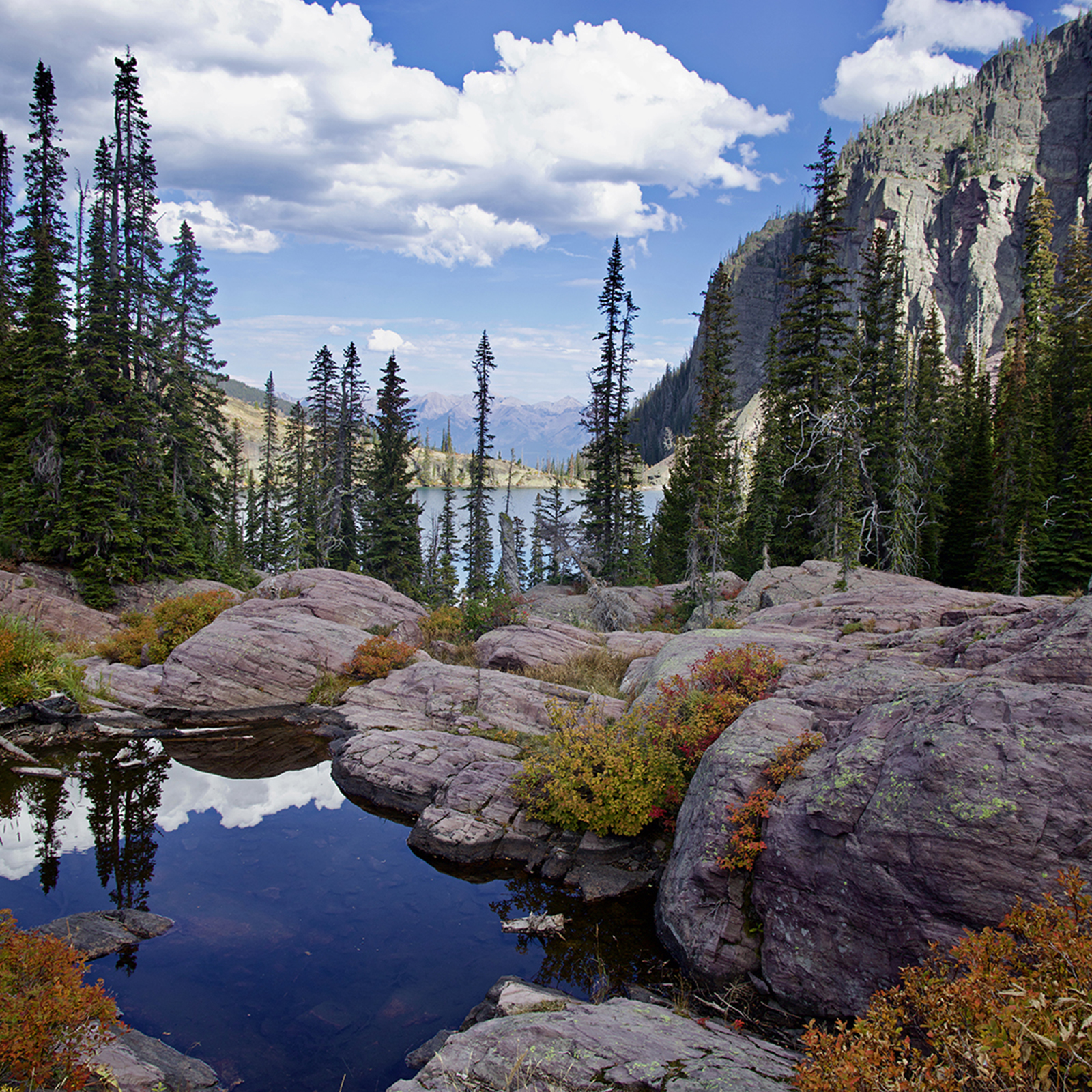
These valley lakes are just a preview to the hundreds of other little lakes and tarns that lie hidden in verdant forests and in rugged mountain cirques, waiting to be discovered. Some are reached by a short hike on a trail and others require a more committed effort through thick brush or over a steep, rocky ridge.
There is a sense of expectancy when a hiker approaches a mountain lake for the first time. Some lakes lap a rocky shore or nestle the contours of a hill of rocky scree; others lie peacefully in meadows spattered with a rainbow of wildflowers. Still other lakes are for the more adventurous, girded by a brushy shore that frames the glistening water or by bleached and polished driftwood that winds have stacked up along the shoreline.
Mystical and mysterious with stunning scenic beauty, lakes can offer a hike destination and a welcome break. A swim to cool off on a hot summer day, a quiet place to cast a line from the shore, a leisurely lunch on a rocky outcrop, or maybe simply, a place to water the dog.
On the northern end of the Swan, gem-like lakes dot the entire Jewel Basin, with at least 28 spattered across more than 15,349 acres that are designated for hikers only. Several lakes can be reached in two or three miles while others require a longer hike and an ability to navigate off-trail routes.
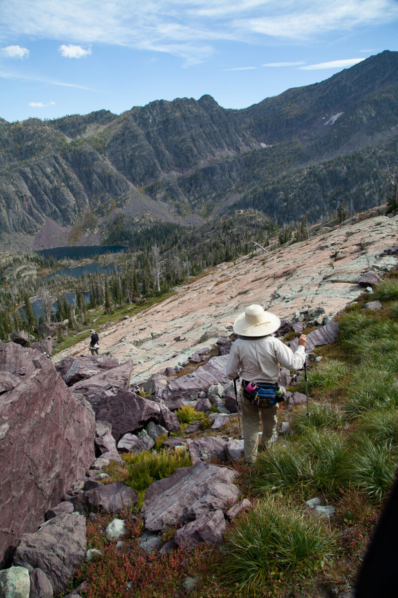
Go a little further down the Swan Range and you will find several trails leading to lakes. Strawberry, Hall, Bond and Trinkus lakes can be reached on a forested day hike that also ties in to Alpine Trail #7, a 75-mile corridor hugging the Swan’s rocky crest and featuring broad, sweeping views of the Mission Mountains, Whitefish Range, Glacier Park, Flathead Lake and the valley below.
The expansive 1-million-acre Bob Marshall Wilderness has numerous lakes, but is probably better known for its limestone cliffs, sprawling river valley and outfitter access for horseback and hunting trips. Reaching most of the high mountain lakes in the Bob Marshall Wilderness from the Swan Valley side requires a longer day hike or overnight trip.
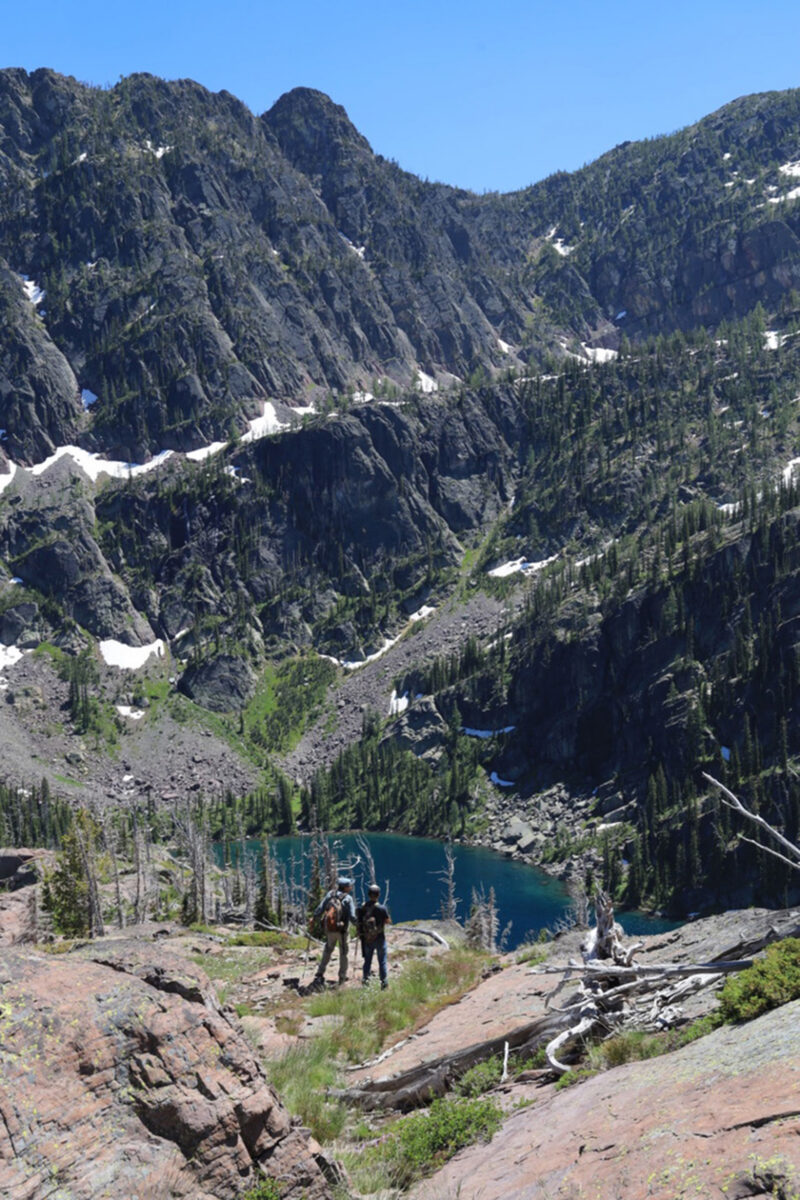
The Mission Mountains Wilderness is sprinkled with over 100 lakes that are greater than an acre in size. Many of the lakes can be reached on a day hike while others require a trek through brushy, rocky and uneven terrain, navigation skills, and an overnight trip.
Some of the most accessible lakes are also predictably the busiest. Glacier Lake in the Mission Mountains, which is reached in one and a half miles, is probably the most visited place in the Mission Mountains. Birch Lake in the Jewel Basin is also a popular hike, because of its round-trip distance of six miles and proximity to the Flathead Valley area. For those willing to hike farther or off trail, there are numerous lakes that will offer more solitude. If you spill over the crest of the Missions there are more than 100 additional lakes in the adjoining Mission Mountains Tribal Wilderness, where access requires a special permit from the Confederated Salish and Kootenai Tribes.
These mountain lakes were first visited by the Flathead and Pend d’Oreille Indians who hunted, gathered berries and fished here. Archaeologists have documented sites showing that native Americans lived in the valley as long as 12,600 years ago and ancient tribal stories suggest that their ancestors were here when the ice age began 40,000 years ago.
Much later, in the late 1800s and early 1900s, the wild and scenic landscape of the Swan attracted early settlers who often relied on the land to furnish them with food and shelter. The popularity of fishing probably explained why most of the early trail use was to reach Glacier Lake, Cold Lake, and Crystal Lake.
The area was also being discovered as a playground for the wealthy. Many of the lakes and mountains in the Mission Mountains Wilderness were named during an exploratory trip in 1922 guided by Theodore Shoemaker and Jack Clark to scout the area for the Northern Pacific Railroad Company (NPRC) to promote tourism, followed by another trip with the Montana Mountaineers, a hiking and climbing club. Afterwards Shoemaker created a map that included place names. According to Shoemaker, a photographer on the NPRC trip, Ashael Curtis, named Turquoise Lake, “because it looked nothing so much as a great mass of turquoise stone melted and run into its basin by the heat of some hidden fire.”
Names often reflect the character of the lake. Turquoise Lake’s bright blue-green color is due to the presence of glacial flour in the lake. Cold Lake normally stays frozen until mid-June and the deep lake remains frigid most of the summer. Heart, Crescent and Necklace lakes were named because of their shapes.
Others in the Swan area, such as Conko, Bond, Rumble, and Cheff, were named after people significant in the area’s history. “Swan Valley Name Places,” written by local outdoorsman and historian Steve Lamar, includes the origins of the names of many of the lakes in the Swan Valley area. He says that Seepala Lake in the Mission Mountains Wilderness was probably given its name due to the numerous seeps that flowed from the lake and the result of a misspelled “seep a lot.”
Lamar cites a 1965 Forest Service report stating that Gray Wolf Mountain was named by the Montana Mountaineers climbing group in the 1920s because the mountain looked like the silhouette of a running wolf when viewed from the north side of the peak. The lake below was subsequently named Gray Wolf even though it first appeared as Dumbbell Lake in a sketch map by Shoemaker, probably because of its shape when viewed from the crest of the Missions. Spanning 342 acres in area, Gray Wolf Lake is the largest lake in the Missions. It is the alpine headwaters of the Swan River, which flows 95 miles through the Swan Valley, to Swan Lake, turning again to river before emptying in Flathead Lake.
Mountain lake season can be short, with ice remaining on the surfaces until mid-June or into July. Many of them remain cold throughout the summer, fed by snowfields that linger on northern slopes, and snowfall that can fall year-round.
Anthony Butterfield, the recreation management specialist for the Swan Lake Ranger District, has a vivid memory of the unpredictability of weather in the high country during his early days working on trails with the Swan Lake Ranger District. He was 21 years old and on his last hitch before returning to college. The trail crew was working on a reroute on Alpine Trail #7 in mid-August. He remembers, “Our day started with pleasant 60-degree overcast skies, but when we had made it about halfway to our camp, it started pouring. By the time we arrived at camp two hours later, we were soaked. Most of us were borderline hypothermic.” They made the call to tough it out and slept by the fire in hopes of drying out.
He continued: “It was a long night with the constant sound of rain hitting the tent roof. We awoke the next morning to silence, but not the silence of a warm August day. The quiet muffled silence of falling snow.” The next several days were a mix of rain, mud and fog. By the end of the stint, they were ready to go home.
“August is typically a great month to hike and visit the Swan Mountain Range, but mountain weather is unpredictable and we can get rain, snow, and windstorm systems that make it feel like April,” Butterfield said, advising that it is always good to be prepared and to know your limits.
Mountain lakes in the Swan have always been popular fishing destinations. Cal Tassarini, the first Mission Mountains wilderness ranger, shared memories of fishing in the 1960s, published in the “Montana Voices of the Swan” oral history book. “It was fantastic fishing. You caught your ten … you never thought twice about catching your limit,” Tassarini wrote. “And that’s probably why you can’t catch your limit now, is because we kept so many in the early days.”
Over the years, the Montana Department of Fish, Wildlife and Parks (FWP) has stocked some of the lakes with fish (mainly westslope cutthroat trout) while others are self-sustaining or fishless. A few lakes have been stocked illegally by sportsmen over the years, resulting in hybridized fish. Luke Lamar, a wildlife biologist, former ranger and director at Swan Valley Connections (SVC), said he has observed that the most heavily used lakes are those offering fishing opportunities.
As outdoor recreation grew in popularity, measures were taken to protect these wild places. Wilderness areas were first by protected the 1891 Forest Reserve Act, implemented to establish forest reserves, to protect wooded areas from logging and other uses, followed by the formation of the Flathead Forest Reserve in 1897. In 1931 it was established as a Primitive Area to protect the area from development in order to preserve it in in its natural state. The ultimate protection came in 1975 when the eastern side of the Missions was officially classified as wilderness. The Bob Marshall Wilderness was established in 1964. The 15,349-acre Jewel Basin Hiking Area was established in 1970 as a hiker-only area to protect the fragile ecosystem.
The difficult balance of protecting wild places, while still offering a sense of freedom to visitors, has been considered when imposing restrictions in heavily used areas. Overnight camping is prohibited at Glacier Lake as well as at lower and upper Cold Lakes in the Mission Mountains to protect the fragile shoreline and allow restoration of the damaged waterfront. Even though camping is allowed at Jewel Basin lakes, open fires are prohibited within 500 feet of the shores of Twin, Picnic, Birch and Crater lakes.
Forest rangers and trail crews work tirelessly to keep trails maintained and to educate the public on Leave No Trace practices that will preserve the backcountry experience for everyone.
SVC partners with the U.S. Forest Service to provide trail and ranger services in the backcountry of the Mission Mountains Wilderness and along the Swan Front. In recent years, Forest Service funding, staff and capacity have been reduced while use has increased. Luke Lamar, who oversees trail work for SVC, said the majority of this year’s funding comes from FWP’s Trail Stewardship Grant Program, which helps ensure that trails are cleared and maintained.
Daughter of the Sun Back Country Services has been contracted for the 12th consecutive year to clear trails, complete trail maintenance, campsite naturalization, and visitor education on 50.3 miles of trail in the Missions and 40 miles in the Swan Front. This year marks Kaydee Borchers’ 10th summer with Daughter of the Sun Back Country Services and Nathan Noble’s 12th.
After beginning trail work in May, Borchers reported encountering one of their heaviest seasons on record, with widespread heavy blowdown from this winter’s storms. Motorized tools are prohibited in wilderness areas, so a crosscut saw is used for blowdown removal, making it even more challenging when they encounter huge trees scattered across trails as far as they can see.
In addition to maintaining established trails, Borchers and Noble spend time at backcountry lakes such as Jim Lakes, where there are no maintained trails, to restore wilderness conditions compromised by too much use or illegal activities such as establishing camps, fire rings and leaving caches of camping gear.
Borchers said that as wilderness use increases, they occasionally weigh the impacts of visitor use and adjust their maintenance plan. For example, even though they normally break down fire rings in step with the Leave No Trace policy of the wilderness area, they have left established fire rings at certain high-use campsites to reduce the impact of campers establishing random fire rings throughout the area.
Borchers said one of the more memorable jobs occurred when she discovered an abandoned cached campsite near Upper Cold Lake. There was a substantial amount of deteriorating gear that included tarps, cots, sleeping bags, raft and a machete. Faced with the formidable task of packing out all the gear through the brushy, downfall-covered, unmaintained portion of trail, they instead came up with the idea to go by water. They created a barge with a raft and inner tubes and ferried the gear across Upper Cold Lake to reach the lower lake before packing it down another two miles to their truck at the trailhead. It took three trips. “It was such an adventure,” Borchers recalled.
But it’s the sense of adventure that attracts visitors to the wilderness in the first place, Borchers said.
“People want to create memories,” she said. “It creates a sense of place.”
For Borchers, it is also a deeply rooted part of her life. When she is covered in soot after breaking down an illegal campfire, or covered in dust from trail work on a hot day, what does she do? She heads to the lake and jumps in for a swim.