Silvertip Fire in Bob Marshall Wilderness Grows to 4,136 Acres
The wildfire is burning 15 miles southeast of Spotted Bear Ranger Station in the Bob Marshall Wilderness. Officials issued a fire watch this weekend as hot, dry and windy conditions are forecast to elevate danger.
By Maggie Dresser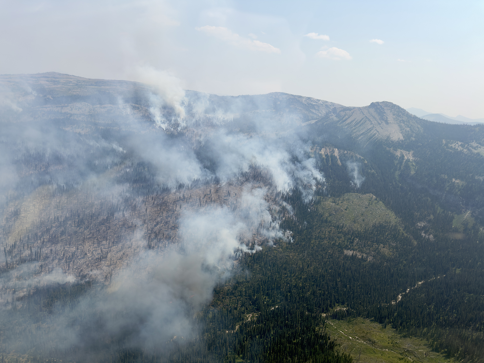
The Silvertip Fire located 15 miles southeast of Spotted Bear Ranger Station in the Bob Marshall Wilderness is actively burning 4,136 acres after lightning ignited the blaze on Friday, prompting Flathead National Forest officials work to implement multiple trail closures.
Fuels are burning on both sides of Silvertip Creek, with most growth occurring to the south towards Silvertip Mountain with spotting to the east toward Ibex Mountain. Most fire activity is occurring in the late afternoon and evening, according to Flathead National Forest spokesperson Kira Powell.
On Tuesday, winds picked up, clearing out the wildfire smoke but increasing fire activity from 1,800 acres to 4,136 acres at last perimeter mapping, Powell said.
The fire is located approximately 5 miles southwest of Pentagon Cabin in a high-risk and remote area, presenting challenging conditions for firefighters to successfully engage directly. Responders are applying an indirect confinement strategy and are working to provide point protection at Pentagon Cabin, which is the closest structure to the fire. No critical values or structures are threatened.
The Silvertip Cabin will remain open for those with reservations.
Flathead National Forest officials are working to implement the following trail closures.
Sergeant Creek–Corporal Creek Trail (Trail 88)
Closed from Spotted Bear River to its junction with Trail 584 (Harrison Creek Trail).
Harrison Creek Trail (Trail 584)
Closed from its junction with Corporal Creek Trail 88 to its junction with Trail 103 and Trail 89.
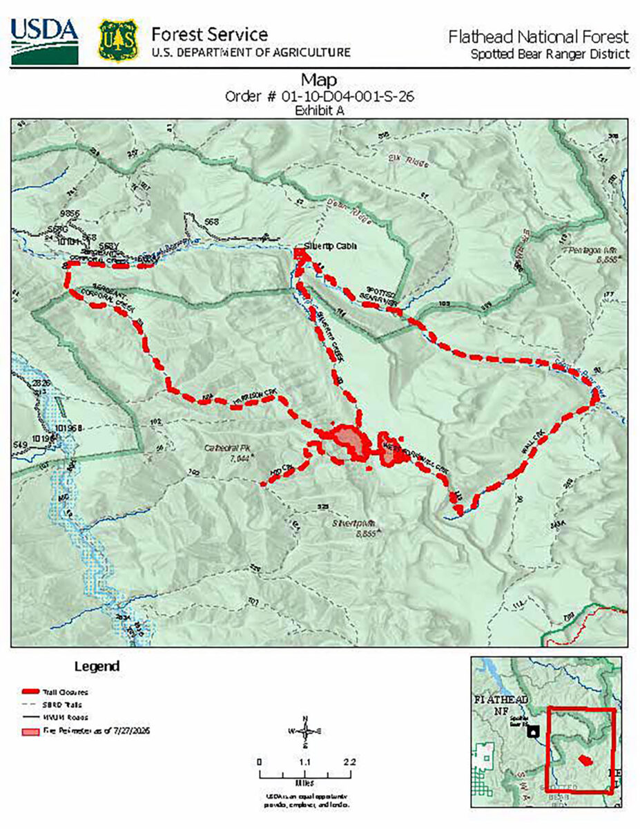
Trail 103
Closed from its junction with Trail 524 to its junction with Trails 89 and 584.
Silvertip Trail (Trail 89)
Closed from the Silvertip Cabin to the end of the trail.
Spotted Bear River Trail (Trail 83)
Closed from its junction with Silvertip Trail 89 to its junction with Wall Creek Trail 90.
Wall Creek Trail (Trail 90)
Closed from its junction with Trail 83 to its junction with Trail 229.
West Fork Wall Creek Trail (Trail 229)
Closed in its entirety.
Meanwhile southeast of Trego, the Advent Creek fire straddling the Flathead and Kootenai national forests is currently 80% contained, as of July 27, while crews continue reinforcing a direct fire line, hand line and heavy equipment line and mop-up operations around the perimeter line.
The Williams Creek trail closure has been lifted but officials urge caution in the burnt fire areas and around hazardous trees and loose soil, according to the Kootenai National Forest.
Air quality has improved in the last 24 hours across the Flathead Valley and smoke models show light to moderate smoke covering much of western Montana from domestic and wildfires in Oregon and Washington, according to the Montana Department of Environmental Quality (DEQ).
According to the National Weather Service (NWS), a fire watch is in effect from Aug. 1 to Aug. 2 as hot, dry and smoky conditions are expected to persist across the Northern Rockies through the weekend with a dry thunderstorm potential Thursday afternoon across southwest and west-central Montana.
A cold front is forecast to enter the region on Saturday night, bringing strong, widespread westerly winds sustaining 10 to 25 mph with gusts up to 40 mph that is expected to elevate fire conditions. Winds will create choppy lake conditions and a 20-degree drop in temperatures by early next week.