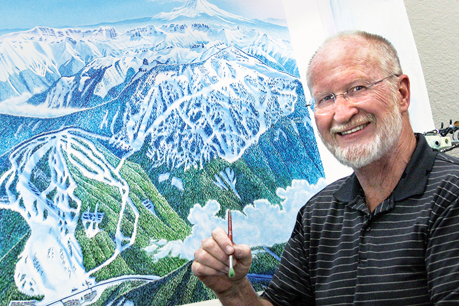
Even though most of James Niehues paintings have never been displayed in an art gallery, just about anyone who has snapped on a pair of skis from Australia to America is familiar with his work.
Niehues, 67, lives in Loveland, Colorado and has spent the last 26 years painting trail maps used by ski resorts around the world, including Whitefish Mountain Resort. In three decades, Niehues has painted nearly 300 maps.
The maps are well known in the ski community for being both beautiful and useful. A 2010 Denver Post story about Niehues likened him to the “Norman Rockwell of ski resorts.”
“I put a lot of details into the maps so they are both artistic but also convey a lot of information,” Niehues said in an interview with the Beacon. “It has to be right and it has to be correct. (It’s a map) and it has to convey useful information to the viewer.”
Niehues was first attracted to art as a kid when his mother gave him a paint set. As an adult he worked in advertising and printing. In the 1980s, when he was working at a press shop in Denver and painting display boards for attorneys, he met Bill Brown, who made a living painting ski resort maps.
Brown was a member of a small guild of trail map artists, which also included Hal Shelton, Don Moss and Murray Hay. Brown was getting ready to retire when he took Niehues under his wing and had him paint a small inset map for Winter Park Resort in Colorado. Niehues spent weeks working on the map – mostly at night because he was still working at the print shop – before Brown presented the map to the client. After the resort accepted it, Brown had Niehues sign the map with what would become his unique signature found on hundreds of maps around the world.
Soon, all of the work that had been going to Brown began going to Niehues.
“It started quick,” Niehues said. “When I look back at all of the things I’ve done, it still surprises me because I had no idea what I was getting into back then.”
The process of creating the map begins the same for every mountain. Whenever he can, Niehues tries to visit a mountain in order to get a lay of the land, although that’s not always necessary. The most important ingredient for maps are aerial photographs of the mountain from different angles. Niehues said in recent years he has tried to use Google Earth images, but they are rarely detailed enough.
Niehues will sketch a draft of the map and then send it to the resort for review. When both parties are satisfied with the first draft, he scans it and then projects it on to his 30- by 40-inch canvas and begins tracing the mountain by hand. Once the landscape is sketched, Niehues paints the scene by hand, painting the snow and sky with an airbrush. He said a smaller resort takes up to a week to paint whereas a larger one can take two to three weeks.
Once the painting is completed, he takes a high-quality digital image and sends the file to the ski resorts. The resorts then add text and location information. So while the Whitefish Mountain Resort trail map shows where all the chairlifts are, the original painting, produced in 1997, shows Big Mountain as an almost untouched landscape.
Niehues said Big Mountain is one of his favorite paintings because it was one of the first mountains he could include an alpenglow, despite the fact that management was initially reluctant to include it.
“I included the alpenglow anyway because it was just so beautiful,” he said. “It was probably the first time I had ever gone against a client’s wishes.”
The map that Niehues produced 17 years ago for Whitefish Mountain Resort is still used today, albeit with a few changes. With the addition of the Flower Point chairlift, creative specialist Lindsey Ebersberger used Photoshop to cut new runs into the trees and works with members of the ski patrol to make sure the locations and angles are correct.
Ebersberger said she works tirelessly to maintain the same feel and look of Niehues’ original painting, going as far as creating shadows by the trees.
“James Niehues’ trail maps are just ingrained in the ski culture,” she said. “They’re nostalgic. They’re beautiful maps and they’re fun to look at.”
It’s unclear how much longer Niehues will produce his iconic maps. At 67, he’s semi-retired from the craft and only takes on a few projects a year. He hasn’t found anyone to carry on the tradition and said it would be hard to produce trail maps that evoke the same type of emotion on a computer.
“You can’t create the same effects on a computer,” he said. “If you made one digitally it’s just going to look like something out of an office and the whole reason people going skiing and go outdoors is to get out of the office. I like to think that trail maps will always be painted, but sadly it may just go to the digital world.”
Despite the future of his unique craft being uncertain, Niehues said he has had a great time traveling the world and painting trail maps.
“It was pretty amazing to go to a ski area the first time and see one of my maps blown up and see my name the corner,” he said. “It still impresses me.”