The Latest
— Three fires surface on west side of Glacier Park
— Numerous trails and backcountry campgrounds closed
— Gibralter Ridge Fire east of Eureka grows to more than 1,600 acres
Updated: Aug. 11, 3:20 p.m.
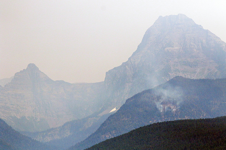
Crews are busy suppressing three wildfires burning on the west side of Glacier National Park following a storm that produced more than 150 lightning strikes late Thursday, prompting trail and backcountry campground closures.
The largest blaze is the Sprague Fire east of Lake McDonald and south of Mount Brown, which scorched 10 acres overnight. Initial estimates suggested the fire was more than 50 acres, but Glacier National Park spokesperson Lauren Alley said a flight over the park on Friday morning was able to record a more accurate size. Multiple helicopters are attacking the priority blaze and firefighters have been dropped on the incident.
The Rogers Fire is currently estimated at 2 acres but it is producing sparse amounts of smoke, according to Alley. A new start was also detected near Howe Lake that is estimated at less than one-tenth of an acre.
As of Friday morning, the following trails were closed in Glacier Park:
Apgar Lookout Trail
Howe Ridge Trail
Camas Trail
Trout Lake Trail
The Sperry Trail from Lake McDonald to Sperry Chalet
Mount Brown Trail
The Snyder Trail
John’s Lake Trail
Lincoln Lake Trail
The Arrow, Camas, Snyder, Sperry, and Lincoln backcountry campgrounds are also closed.
No new overnight backcountry camping permits will be issued on Friday to reduce the number of people staying in the backcountry while park officials assess the situation. No horseback rides will depart from the Lake McDonald Corral on Friday.
»»» Click here to view a map of the reported fires
There were 42 guests at the Sperry Chalet and they were advised to either hike out via the Gunsight Pass Trail or remain in place until park officials assess the Sprague Fire. The structures in the Sperry Chalet complex are not immediately threatened, according to park officials.
There were 39 guests at the chalet who began hiking out over Gunsight Friday morning, while three stayed with staff, according to a person close to the situation.
Park rangers are also leading out hikers who were staying in backcountry campgrounds near the fires.
A Type III incident management team has been assigned to the fires in the park and additional firefighting resources are being sent to the area.
»»» Glacier Park: What’s Open and What’s Closed
Thursday night’s storm also knocked out power on the west side of Glacier Park, but it was restored by late morning Friday. Nearly 5,000 members temporarily lost power in the West Glacier and Hungry Horse areas, according to Flathead Electric Cooperative.
The Flathead Interagency Dispatch Center received 56 calls to 911 about power line emergencies, many of which caused small fires that crews quickly extinguished, according to the local emergency services agency.
Janette Turk, spokesperson with Flathead National Forest, said aircraft will be scanning the mountains for potential new fires after dozens of lightning strikes overnight.
The Gibralter Ridge Fire, east of Eureka, grew another 200 acres in the last 24 hours. It is now 1,652 acres. Last night’s thunderstorm brought high east winds that caused several spot fires to develop on the west of Foothills Road.
Fire crews responded to the new starts and worked through the night to suppress the flames. One of the new fires is located just across the Foothills Road and north of the intersection with the Lick Lake Road. These small fires are generally located near the Foothills Road and Lick Lake Road junction.
As of 6 a.m., no structures had been lost to the fire but several are threatened. These wind-driven spot fires will continue to be a challenge for firefighters throughout the day, according to fire managers.
A public information meeting is scheduled for 6 p.m., Friday evening at the Lincoln County High School gym.
Firefighters are also battling a fire on the east side of Flathead Lake. The Blue Bay Fire has burned 17 acres in the Mission Mountains about a mile from Montana Highway 35, according to Confederated Salish and Kootenai Tribes fire prevention specialist C.T. Camel. No structures are threatened at this time. A hand crew and air resources, including two CL-215 scooper planes based at Glacier International Airport, were battling the blaze early Friday afternoon.
Smoke is blanketing the region and harming air quality conditions. Air quality in Seeley Lake is considered hazardous, and health officials are encouraging resident to evacuate. Seeley Lake registered air pollution levels Thursday morning 38 times above what the World Health Organization says is safe, the Associated Press reported.
Air Quality Conditions
As of Aug. 11
Source: Montana Department of Environmental Quality
Hazardous
When air quality is “hazardous,” health officials recommend everyone should avoid any outdoor exertion; people with respiratory or heart disease, the elderly, and children should remain indoors.
— Seeley Lake (recommended evacuation)
Very Unhealthy
When air quality is “very unhealthy,” health officials recommend people with respiratory or heart disease, the elderly, and children should avoid any outdoor activity; everyone else should avoid prolonged exertion.
— Quartz Creek near Superior
Unhealthy
When air quality is “unhealthy,” health officials recommend people with respiratory or heart disease, the elderly, and children should avoid prolonged exertion; everyone else should limit prolonged exertion.
— Arlee
— Lolo
— Missoula
Unhealthy for Sensitive Groups
When air quality is “unhealthy for sensitive groups,” health officials recommend people with respiratory or heart disease, the elderly and children should limit prolonged exertion.
— Libby
— Thompson Falls
Moderate
When air quality is “moderate,” health officials recommend that unusually sensitive people should consider reducing prolonged or heavy exertion.
— Clearwater
— Flathead Valley
— Butte
— Dillon
— Helena
— Bozeman
— Great Falls
— Lewistown
Tinderbox conditions are plaguing the region, creating high fire danger.
Strict fire restrictions are in place across Western Montana, prohibiting campfires and internal combustion engines without a spark arrestor in the outdoors. Stage II restrictions mean people are prohibited from using motorized vehicles off road; operating any internal combustion engines during certain hours; having a fire of any kind, smoking or using fireworks.
This story will be updated when more information becomes available on Aug. 10. For future updates, visit Flatheadbeacon.com.