The Latest
–Historic Sperry Chalet burns to the ground in Glacier
-Pre-evacuation warnings issued near Eureka after Gibralter Ridge Fire grows to 6,500 acres
–13 new fires start on the Kootenai National Forest
Updated: Aug. 31, 9:45 p.m.
»»» Click here to read the latest story on this incident
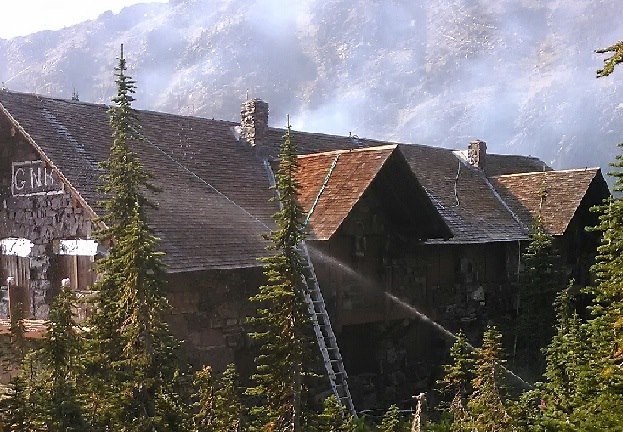
A historic Glacier National Park chalet was lost Thursday evening as a rapidly growing wildfire spread in the hills east of Lake McDonald.
Glacier National Park officials confirmed that the two-story Sperry Chalet caught fire late Thursday afternoon when the Sprague Fire made a significant run east. Firefighters stationed at the chalet made what officials called a “valiant” effort to save the structure but were unsuccessful. All firefighters stationed at the chalet were safe, according to officials.
At about 7 p.m., firefighters were regrouping and trying to save outbuildings at the Sperry Chalet site.
The Sperry Chalet was closed earlier this month when the Sprague Fire first started east of Lake McDonald. In recent weeks, the hoses and sprinklers were set up to protect the building but it was not enough in the end.
The Sperry Chalet was built in 1913 and was one of a series of wilderness lodges built by the Great Northern Railway.
Ray Djuff , Glacier Park historian and author of the book “View with a Room” about Glacier Park’s lodges and chalets, said the loss of Sperry will be felt by legions of backcountry enthusiasts.
“The chalets were a welcome respite for backcountry travelers and offered incredible service in the middle of nowhere,” he said. “I’m stunned… But we have to count our blessings that we had the Sperry Chalet for so long.”
As of Thursday night, the Sprague Fire had scorched more than 3,275 acres just two miles east of Lake McDonald, forcing the closure of the historic lodge there ahead of the busy Labor Day Weekend due to hazardous smoke conditions. The popular Avalanche Trail was closed earlier in the day as the fire started to grow.
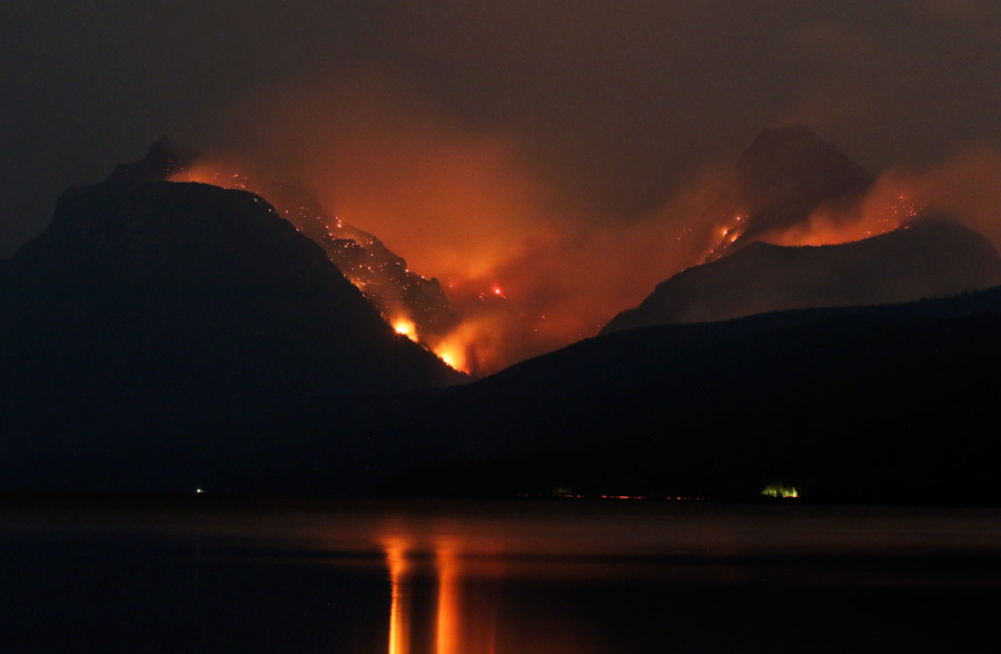
The fire in Glacier is one of dozens across western Montana that have blanketed the region with smoke.
The National Weather Service in Missoula issued a Red Flag Warning for all of western Montana through 9 p.m., Thursday as a cold front brings dry and breezy conditions into the area.
The Gibralter Ridge Fire has grown rapidly in recent days, torching more than 6,500 acres east of Eureka and forced the Lincoln County Sheriff’s Office to issue new pre-evacuation notices. Residents in the Sherman Creek, Griffith Creek, Therriault Pass, Stevens Creek, Glen Lake and Sinclair Creek areas are being encouraged to prepare to leave if fire activity spikes. A Type II incident management team was expected to take command of the fire on Aug. 31. As of Thursday morning, the fire was 39 percent contained.
The same Type II incident management team that is taking command of the Gibralter Ridge Fire will also be managing the 3,290-acre Caribou Fire about 21 miles west of Eureka. The lightning-caused fire started Aug. 11 in a remote section of the Kootenai National Forest and has burned across the border into British Columbia. Firefighters are building containment lines east and west of the fire.
At least 13 new fires ranging in size from 1 acre to 300 acres were sparked on the Kootenai National Forest by a lightning storm on Aug. 29. The largest of the fires is the 300-acre Cub Creek Fire on the Cabinet Ranger District near Trout Creek. The 108-acre Reader Fire west of Thompson Falls has forced local law enforcement to issue pre-evacuation notices for residents in the Little Beaver, Beaver Creek, and White Pine areas. Pre-evacuation notices have also been issued for residents in the vicinity of the Moose Peak Fire and Miller Creek Fire, including some residences in the East Fisher area north of Thompson Falls. Both fires were listed at approximately 135 acres on Thursday.
A number of fires are also burning deep in the Flathead National Forest. The Reef Fire has burned nearly 650 acres near Count Peak in the Bob Marshall Wilderness. The fire is being allowed to play its natural role on the landscape and is being monitored from the air. The Scalp Fire has burned 493 acres near Bow Mountain in the Bob Marshall Wilderness and is visible from the Spotted Bear and Beartop Lookouts. The Dolly Varden Fire has torched 185 acres in the Great Bear Wilderness.
On the Lewis and Clark National Forest, the Crucifixion Creek Fire has burned more than 1,400 acres in the Badger-Two Medicine, southwest of Heart Butte. Officials said the fire does not pose an immediate threat to any structures or communities at this time. A public meeting about the fire is scheduled for 6 p.m. Friday in Heart Butte.
The Blue Bay Fire continues to burn in the hills directly east of Flathead Lake. As of Wednesday, it had burned 490 acres and was 40 percent contained. Fire managers expect more activity in the coming days as warm and dry weather returns to the area.
Stage II fire restrictions, which prohibit campfires and the use of some internal-combustion engines during certain hours, remain in effect.