
The prayers for snow worked. Cold temperatures and storms dropping inch after inch of snow in late December have delivered one of the snowiest winters in recent memory, with Whitefish Mountain Resort reporting in early January the most snowfall Big Mountain has seen in nearly 20 years.
By other measurements, the region’s snowpack is in good shape. Across the entire Flathead River Basin, which stretches south from the North Fork Flathead in Canada to the Mission Valley, the snowpack on Jan. 1 was at 96 percent of normal, compared to 83 percent on Jan. 1, 2016, according to a USDA Natural Resources Conservation Service outlook report released earlier this month. The seven NRCS SNOTEL stations in Flathead County are reporting both strong snow depth and snow water equivalent numbers, all surpassing or nearing historical averages.
Every SNOTEL station in the Flathead Valley is reporting deeper snow than at the same time last year. On Jan. 10, the SNOTEL stations at Hand Creek and Badger Pass both reported 123 percent of the period of record (POR) average snow depth, which is 24 inches at Hand Creek and 49 inches at Badger Pass. Just one station tallied less than 90 percent of the POR average, with stations at Grave Creek, Flattop Mountain, Emery Creek, and Blacktail Mountain reporting a snow depth between 91 and 96 percent of the average. Noisy Basin, the station reporting the lowest percentage of the average, on Jan. 10 had nine more inches than last year.
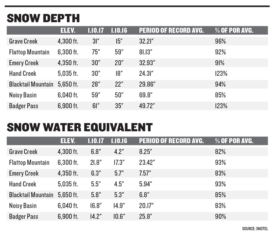
All SNOTEL stations also reported better numbers for snow water equivalent on Jan. 10 than on the same date in 2016. Four stations reported between 82 and 85 percent of the POR average, and three stations reported between 90 and 93 percent. Snow water equivalent, a measurement of the amount of water in the snowpack, is helpful for streamflow forecasting and predicting how harsh the summer fire season could be. It evaluates how much water, come springtime, will slowly melt from the snowpack, which is the state’s biggest water reservoir, and trickle into the valley.
The water year, which began in Oct. 2016, started off on a rainy note, after an “abnormally wet” September that came on the heels of a “relatively dry summer,” according to the NRCS report. October was also rainy, and all seven Flathead sites closed out the month with above average precipitation. Low temperatures kept snow from accumulating at higher elevations through November, and as dry weather moved into the valley in early December, water specialists hoped for a pattern change. That turning point came mid-December when a series of cold-weather storms brought above average precipitation and “significantly” higher snowfall, according to the report. Since Oct. 1, the Flathead Basin has received more than 130 percent of the POR average year-to-date precipitation.
“It was a great start to the water year,” USDA NRCS’s Montana water supply specialist Lucas Zukiewicz, who prepared the January report, said. “If we continue this trend, we’ll be in good shape.”
The four remaining percentage points to 100 percent average snowpack isn’t a concern, especially at this point in the year, Zukiewicz said. He noted that just one big storm cycle could bump the numbers up past historical averages, and his hope is for the snowpack to reach 100 percent by April. By April 1, 2016, all seven Flathead SNOTEL stations reported snow water equivalents within roughly one inch of the POR average.
“We have a lot of winter left to see how things are going to play out,” Zukiewicz said.