The Latest
-Highway 37 Fire has burned 51 acres and is 10 percent contained
-Fire was started by “discarded smoking material”
-Kootenai River north of Libby has reopened after being closed for fire operations
Updated: July 23, 1:45 p.m.
Firefighters made progress over the weekend wrangling a wildfire that started near the old W.R. Grace & Co. vermiculite mine north of Libby.
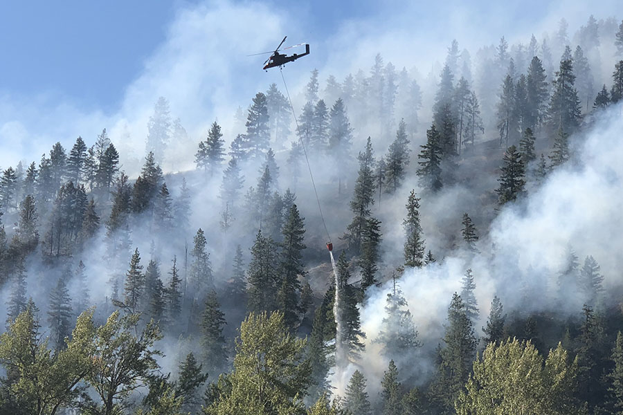
As of Monday morning, the Highway 37 Fire was listed at 51 acres and was 10 percent contained. Fire crews were reinforcing hand line that had been dug around the blaze and utilizing air resources as needed to fight any spot fires.
Officials said the cause of the fire remained under investigation but that it was most likely sparked on July 19 by “discarded smoking material,” such as a cigarette.
Firefighters aggressively attacked the blaze when it was first discovered last week for fear that it would spread into an area called Operable Unit 3, or OU3, which is part of the Environmental Protection Agency’s Libby Superfund site. OU3 is a 10,000-acre site that includes the former mine. Local, state and federal officials have long worried about a wildfire near the former W.R. Grace & Co. vermiculite mine, ground zero for the Libby asbestos contamination, because of contaminated dirt and soil in the area. Officials have feared that a large wildfire near the old mine could release asbestos-laden ash into the air. The fire is burning about a mile away from the old mine.
If the fire did enter OU3, the Lincoln County Health Department would deploy mobile air-quality monitoring stations. Health officials would use information from those monitoring stations to determine if a shelter-in-place order needs to be issued to local residents.
OU3 used to encompass about 35,000 acres directly north of Highway 37, where the fire is currently burning, but its parameters were shrunk in 2017 after the EPA conducted tests that found the soil was not as contaminated in the other acres.
Despite the change in parameters, the U.S. Forest Service still designates the area directly north of Highway 37 as a “modified response zone.” Firefighters who work there are required to receive special training and are outfitted with protective respiratory gear.
Kootenai National Forest Fire Management Officer Dan Rose said the fire was first discovered shortly after 3:30 p.m. on July 19, and within 30 minutes it had grown from a half acre to 30 acres, fueled by hot and dry conditions. Because of the proximity to the former mine site, Rose said local and federal firefighters aggressively attacked the blaze from the ground and air using eight helicopters and nine fixed-wing aircraft. In four hours, the helicopters dropped more than 220,000 gallons of water on the fire from the nearby Kootenai River.
“It was an incredible response,” Rose said.
A section of the Kootenai River between the Osprey Landing boat ramp and the Montana Highway 37 bridge in Libby was closed to enable helicopters to safely get water. That closure was lifted on July 23, according to Montana Fish, Wildlife and Parks.
The Highway 37 Fire comes as the danger for wildfire continues to increase across Northwest Montana. On July 18, the fire danger in the Flathead Valley was raised to “high” and “very high” on the Kootenai National Forest.
Hot and dry conditions are expected to persist into the early part of August in the region and Flathead County Fire Service Area Manager Lincoln Chute said the lack of rain will only increase the fire danger in the coming weeks and that people should be careful when outdoors.
“We can’t do anything about the lack for rain but we can be a little bit more careful in preventing human-caused fires,” he said.
Firefighters have responded to a number of spot fires in the Flathead Valley in recent days, but nothing larger than an acre or two.