Northwest Montana Raises Fire Danger to ‘Extreme’ as Flathead County Declares State of Emergency
Flathead National Forest is working to suppress 17 new starts as wildfires have burned more than 20,000 acres in northwest Montana
By Micah Drew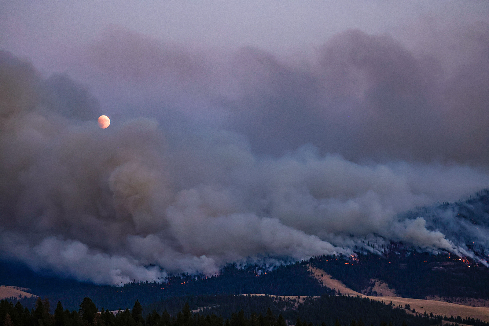
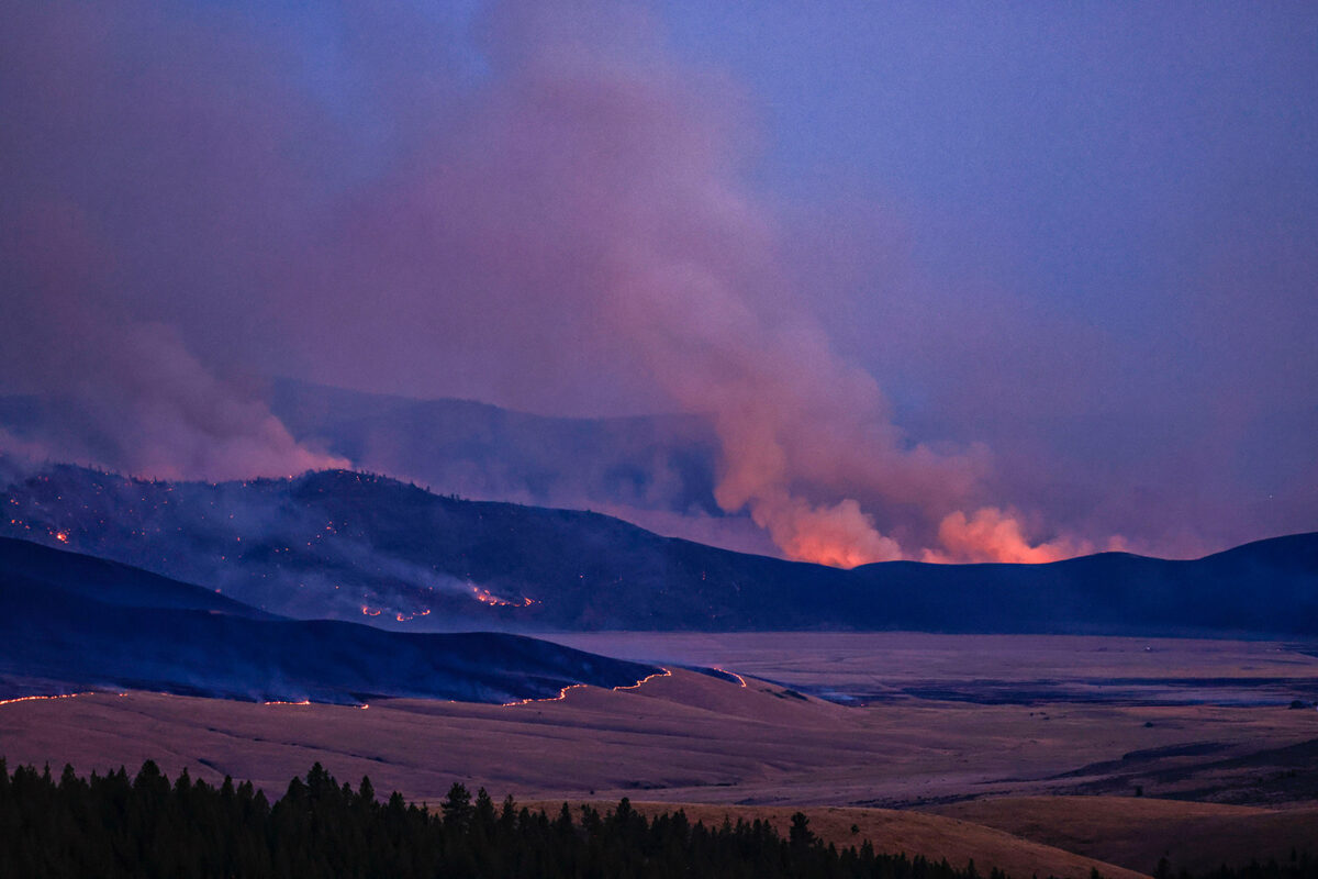
Flathead County officials declared a state of emergency on Aug. 1 as Lake County and the Confederated Salish and Kootenai Tribes (CSKT) adopted stringent restrictions following an aggressive period of wildfire activity that has scorched more than 22,000 acres in northwest Montana since a dry lightning storm ignited dozens of fires over the weekend. The 8,431-acre Niarada Fire burning west of Elmo nearly doubled in size since yesterday’s reports and evacuation orders remain in place for residents along Browns Meadow Road. The North Lake Fire in Whitefish also grew while Flathead National Forest fire managers work to suppress 17 wildfire starts spanning three ranger districts.
As the wildland fire activity intensifies, the Flathead County Commissioners at their Aug. 1 meeting enacted the emergency declaration allowing county agencies to leverage additional resources for firefighting efforts and emergency services.
Fire officials on Tuesday also classified fire danger as “extreme” across the region, although Highway 28 between Elmo and Hot Springs has reopened to traffic with speed restrictions in place.
“After fighting the fires from this weekend, Flathead County is looking good, but that could change at any minute,” Flathead County Sheriff Brian Heino stated in a news release Tuesday. “The Niarada fire has crossed Highway 28 into Sanders County, and we’re watching the East Fork fire in Lincoln County. The North Lake fire is estimated to have grown to 11-12 acres as of this morning with emergency crews still on the scene. Browns Meadows is still under evacuation orders.”
As the fire dangers escalates, fire managers are desperate to prevent additional human-caused starts. Both Lake County and the CSKT had enacted Stage 2 fire restrictions as of Aug. 1, prohibiting the operation of internal combustion engines during the day and any motorized vehicle use off of designated roads or trails.
Emergency officials issued a reminder that Stage 1 Fire Restrictions remain in place across public lands in the Flathead and Kootenai National Forests, in Flathead, Sanders and Lincoln counties, and in Whitefish. The public is encouraged to be prepared for evacuation if asked to leave by emergency responders.
Anyone caught violating the restrictions or closures could be fined up to $5,000 individually or $10,000 for an organization and imprisoned up to six months. Anyone found responsible for starting a wildland fire can be held liable for all suppression costs and damages.
On the Flathead Indian Reservation, tribal, state and federal firefighters continue to battle four lightning-sparked wildfires that have burned more than 16,000 acres. Many of the fires have seen extreme growth with the low fuels moisture and high temperatures.
A Complex Incident Management Team will arrive tonight to take command of multiple fires, bringing more support staff for the increase in fire resources arriving, according to officials with the CSKT Fire Division. For specific fire information, see below.
All tribal lands, as well as the entirety of Lake County, are under Stage 2 fire restrictions beginning Aug. 1. Stage 2 Fire Restrictions prohibit building, maintaining, attending, or using a fire or campfire, with no exceptions allowed in northwest Montana this year. Cooking on a liquid petroleum gas or propane stove that can be turned on and off is allowed.
The restrictions also prohibit smoking, except within an enclosed vehicle or building, a developed recreation site or while stopped in an area at least three feet in diameter that is barren or cleared of all flammable materials. However, all land within a city boundary is exempted unless the local municipalities enact their own set of restrictions.
The following acts are prohibited from 1 p.m. to 1 a.m.:
- Operating any internal combustion engine.
- Welding, or operating acetylene or other torch with open flame.
- Using an explosive.
A one-hour foot patrol in the work area is required following cessation of all activities as identified in #3 above.
In addition, operation of any motorized vehicle off of a designated trail or road is prohibited.
A dry-lightning storm Saturday night caused an increase in fire starts across the Flathead National Forest (FNF) with firefighters responding to 17 fires spanning the Spotted Bear, Hungry Horse-Glacier View and Swan Lake Ranger Districts, according to forest officials on Monday evening.
The largest fires are the 295-acre Kah Mountain fire, the 359-acre Bruce fire and the 193-acre Sullivan fire on the Spotted Bear Ranger District, which fire managers have grouped together with two additional starts as the Tin Soldier Complex, totaling 822 acres, according to FNF Public Affairs Officer Kira Powell. Firefighting crews are responding with an initial attack as a Type 3 Incident Management Team prepares take command of the entire complex.
The Spotted Bear Ranger District had seven reported fires as of Tuesday morning. Alcove and Stadium Creek Fires are in the Bob Marshall Wilderness Complex. The half-acre Elam Fire is burning along the West Side Road on the Hungry Horse Reservoir, where firefighters have constructed containment lines around the fire’s perimeter.
The Hungry Horse-Glacier View Ranger District has nine reported fires, one of which is listed as controlled while two others are now contained, including a tenth-acre fire near Lion Lake reported July 31. The nearby Logan Fire is contained and is approximately one-tenth of an acre, located in timber with an active timber sale to the south. Aerial resources delivered buckets of water Monday morning, slowing the fire spread in support of the firefighters who successfully constructed containment line around the fire.
The Doris Point Fire is estimated at a half-acre and is burning on a slope within thick timber and vegetation with prevalent large-diameter dead trees. Fire personnel were able to approach the fire on Sunday but the risk to firefighter safety is very high due to the fire’s location, officials said. Fire personnel are “working to evaluate opportunities and suppression plans that prioritize safety and probability of success,” according to Powell.
The Ridge Fire is estimated at 50 acres and is actively backing down towards Emery Creek drainage in mature timber with lots of dead and down trees and standing dead snags. “This is a full suppression fire and fire personnel are assessing control features, utilizing old logging roads. Heavy equipment has been ordered to support firefighting efforts,” according to Powell. The nearby Abbot Creek Fire is a single-tree snag burning less than a half-mile from the Ridge Fire and has been incorporated into the Ridge Fire response strategy. The Emery Fire is estimated one-tenth of an acre just south of the Ridge Fire and is successfully controlled.
Currently, there are no fire-related area or road closures on the Flathead National Forest.
Glacier National Park wasn’t spared the spate of wildfire activity as crews responded to four starts on the western side of the park on Monday, all between one-tenth of an acre and one-half an acre in size. As of Tuesday morning, the Brushy and Harrison fires are out, according to Glacier Public Affairs Officer Gina Icenoggle. The Kishinehn Creek fire burning near the Canadian border is contained and firefighters are mopping it up. The Bowman North Fire, also burning in the northern reaches of the park, is less than an acre and firefighters are constructing containment lines around the fire.
Montana’s wildfire dashboard currently shows 74 active fires in the state. For current wildfire and restrictions information visit: https://www.mtfireinfo.org/
Major Wildfire Incidents
Please note that the following reflects the latest information received at the time of publication.
Big Knife
Location: 5 miles east of Arlee
Size: 1,991 acres (adjusted estimate from new overnight infrared flight)
Containment: 0%
Personnel: 122 firefighters
Evacuation Warnings/Orders and Road Closures: No mandatory evacuations at this time. The Canal Road, from Mountain Home Road to the Jocko Canyon Road, is closed.
Operational Updates: A Complex Incident Management Team will command of the fire on Aug. 2. Recent fire growth occurred on the east, west and southern flanks with the fire pushing roughly 1.5 miles to the east
Colt Fire
Location: 12 miles northwest of Seeley Lake
Size: 6,704 acres
Containment: 8%
Personnel: 589 firefighters, 5 helicopters
Current Cost of Operations: $12,210,000
Evacuation Warnings/Orders: Mile marker 31 (Beaver Creek Road at the intersection of Highway 83) south towards Seeley Lake to mile marker 27, and including residences in Rovero Flats, are under an Evacuation Order. Residents on Beaver Creek Road (near the summit) are under an Evacuation Warning. Residences beginning at mile marker 27 (south end of Rovero Flats) to mile marker 25.5 (the intersection of the West Fork of the Clearwater Road and Highway 83) are under an Evacuation Warning. Residences on the north and south ends of Lake Inez are under an Evacuation Warning.
Operational Updates: Fire growth was primarily to the southwest and southeast, with lots of creeping and smoldering fire behavior. Hot, windy conditions Monday led to an increased number of spot fires. Aerial support will be utilized for water and retardant drops when available.
Communication Butte Fire
Location: 2 miles north of Dixon
Size: 845 acres
Containment: 0%
Personnel: 21 firefighters, 2 helicopters,
Current Cost of Operations: $300,000
Evacuation Warnings/Orders and Road Closures: The Bison Range at Moiese has reopened. All evacuation warnings in Moiese have been lifted.
Operational Updates: A Type 4 Incident Command Team is managing this fire with full suppression tactics and continue to put in new containment lines along the fire’s flanks. The fire is burning in grass and timber.
Middle Ridge Fire
Location: 15 miles west of Ronan
Size: 10,970 acres
Containment: 0%
Personnel: 42 firefighters,
Current Cost of Operations: $1,300,000
Evacuation Warnings/Orders: None
Operational Updates: A Type 3 Incident Command Team is managing the fire with full suppression tactics. Fire growth was primarily to the North. The fire crossed the Flathead River to the east.
Niarada Fire
Location: 12 miles west of Elmo
Size: 8,431 acres
Containment: 0%
Personnel: 66 firefighters
Current Cost of Operations: $1,800,000
Evacuation Warnings/Orders and Road Closures: Residents along Browns Meadow Road from Highway 28 to the top of the pass, including Kofford Ridge Road, are under an Evacuation Order. Hubbart Dam Road/NF-544 from the intersection of Crossover Road south to Highway 28 are under Pre-Evacuation Warnings. Montana Highway 28 has reopened from its junction with U.S. 93 at Elmo with speed restrictions. Additional road closures can be seen on the map below.
Operational Updates: Smokejumpers, a 20 person crew, single-engine air tankers, helicopters and heavy equipment have been responding to this fire. The fire is burning in very steep and rugged terrain heading north and east. Winds coming from the west/southwest continue to push the fire north/northeast. The fire had four single-engine air tankers, very large air tanker, five large air tankers, supporting ground resources all day.
Mill Pocket
Location: West of Niarada Fire
Size: 1,546 acres
Containment: 0%
Personnel:
Current Cost of Operations:
Evacuation Warnings/Orders and Road Closures: Road closures along Mill Creek Road and Upper Reservoir Road.
Operational Updates: Dozers are assigned and it has been receiving air support. The fire is progressing east and has moved to the canal.
Tin Soldier Complex
Location: Northwest of Swan Lake
Size: 822 acres
Containment: 0%
Personnel:
Evacuation Warnings/Orders and Road Closures: None
Operational Updates: A Type 3 Incident Management Team is managing the complex.