Fire Growth Continues Despite Weekend Precipitation
While crews battling fires near Seeley Lake and the Flathead Reservation saw some relief over the past 48 hours, the region remains on high alert as a number of fires continue to burn across northwest Montana
By Denali Sagner
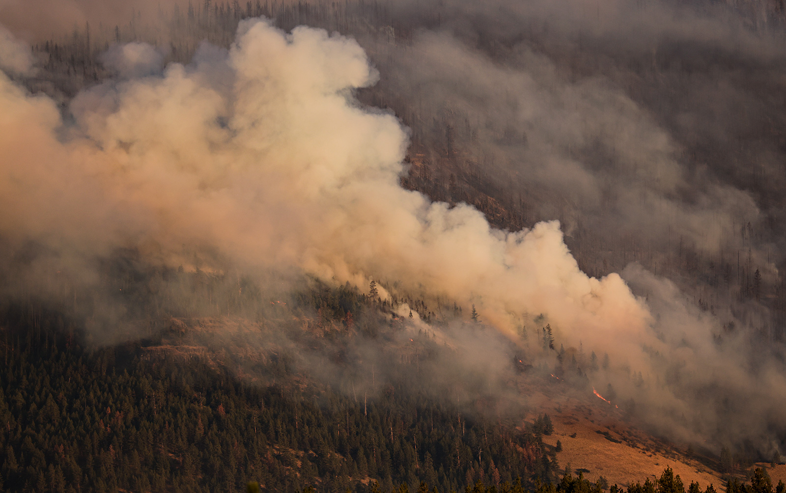
Despite a wave of cooler temperatures and scattered rain over the weekend, crews are continuing to fight a number of growing wildfires across northwest Montana, and evacuation orders and closures remain in place.
On the Flathead Reservation, precipitation moderated the Niarada, Mill Pocket and Big Knife fires, allowing crews to reduce fuels and construct increased fire lines. The Mill Pocket fire is now 35% contained, and the Niarada Fire is 7% contained, as compared to 0% late last week. The Big Knife Fire is 5% contained, as compared to 0% last week.
Rainfall in the southern part of the region also reached the Colt Fire, the largest fire incident in northwest Montana, which has burned through the Seeley Lake area since July 17. The fire is now 25% contained.
The Ridge Fire southeast of Hungry Horse, which saw less precipitation than incidents further south, grew 189 acres since yesterday. Crews are coordinating to assess and protect structures and private property in Coram, Martin City and Hungry Horse.
A number of recreation sites throughout the region remain closed in the Flathead National Forest, Bob Marshall Wilderness Complex and Lolo National Forest. A comprehensive list of closures, evacuation and incident data can be found below.
Major Wildfire Incidents
Please note that the following reflects the latest information received at the time of publication. To see the latest updates for all major wildfires visit inciweb.nwcg.gov.
Ridge Fire
Location: 6 miles southeast of Hungry Horse
Size: 2,773 acres
Containment: 0%
Personnel: 177
Evacuation Warnings/Orders and Road Closures: NFS Road 38, East Side Road, is closed east of the junction of FS Road 497 (Desert Mountain Road) and East Side Road. FS Road 895 (West Side South Fork Road 895) is closed to all public traffic starting at mile 15, near the Lid Creek Campground. West Side South Fork Road 895 will be closed beginning tomorrow, Aug. 8, from the Hungry Horse Dam Visitor Center to the existing closure at mile 15, near the Lid Creek Campground. Pre-evacuation notice in effect for private property along SF Abbot Creek on the west side of the fire.
Operational Updates: After a growth of 189 acres, indirect suppression efforts are being prioritized on the west side of the fire to protect critical infrastructure and private property. Structure protection assessments and coordination are being conducted for private property in Coram, Martin City and Hungry Horse. Heavy equipment is continuing to implement a fuel break near the Nard Money Road to decrease potential fire intensity should the fire reach private property to the west.
Additional Information: There will be a public meeting about the Ridge Fire today, Aug. 7 at 7 p.m. at the Glacier Bible Camp (400 5th St. W.) in Hungry Horse.

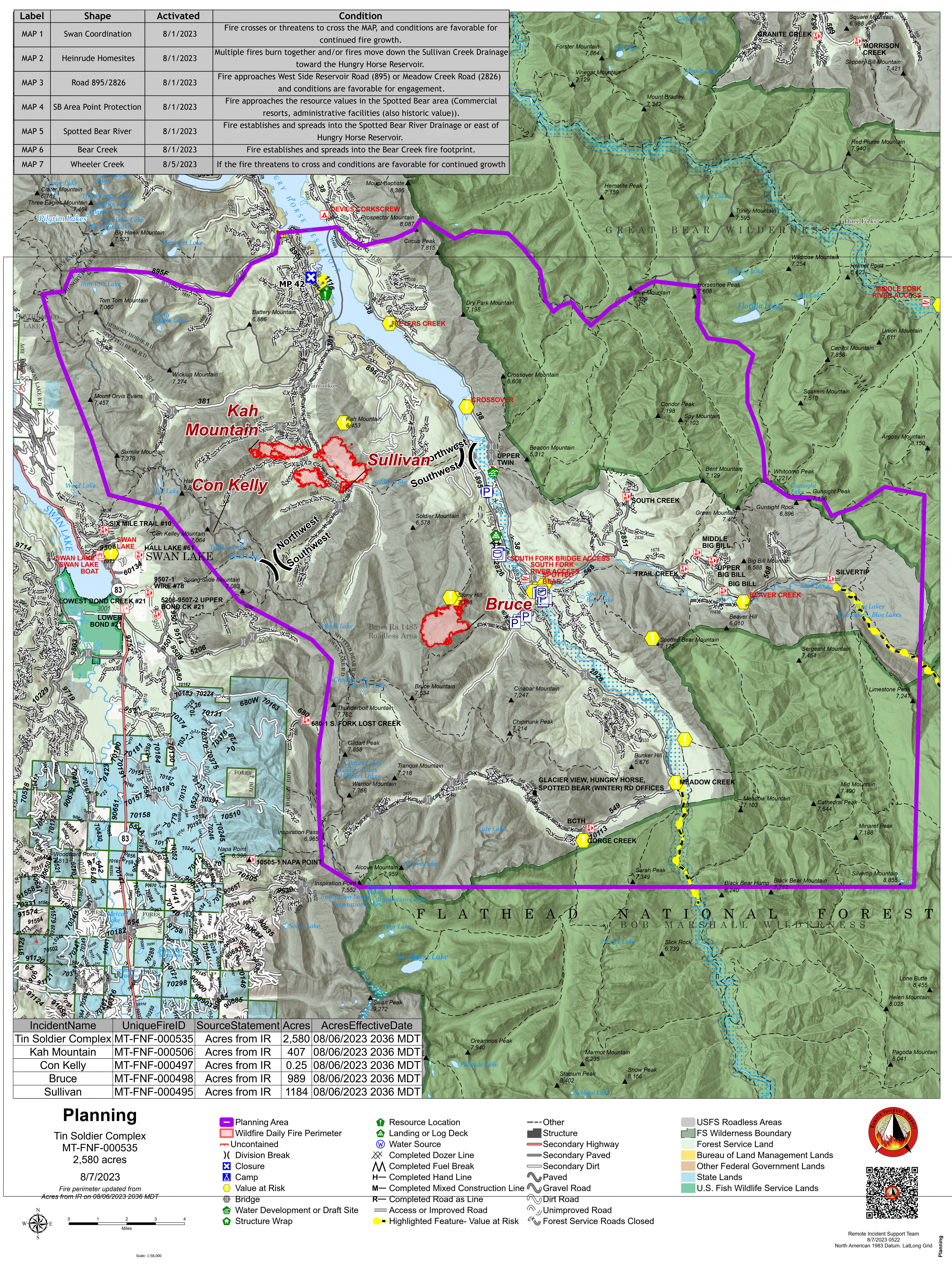
Tin Soldier Complex
Location: 17 miles east of Swan Lake
Size: 2,580 acres
Containment: 0%
Personnel: 75
Evacuation Warnings/Orders and Road Closures: An evacuation order is in place for the Heinrude community. A road restriction is in effect for the East and West Side South Fork Roads. An area closure is in effect for the front country of the Spotted Bear Ranger District and the Gorge Creek drainage within the Bob Marshall Wilderness Area, including Feather, Inspiration, Gorge, Canyon Trickle and Stadium Creeks.
Operational Updates: The Bruce, Kah and Sullivan fires — three of the four fires making up the Tin Soldier Complex — are being managed with point source protection to protect values at risk, including the Stony Communications Site, hydro-electric plant, Heinrude residential community, commercial guest ranches and the Spotted Bear Ranger Station compound. Crews will continue installing hose line and sprinkler systems around the Spotted Bear Ranch, Diamond R Ranch and Spotted Bear Ranger Station compound. Fire personnel are continuing the development of a structure plan for the Heinrude residential community and are focusing on establishing fuel breaks with mechanical equipment.

Mill Pocket / Niarada Fire
Location: 15 / 12 miles west of Elmo
Size: 2,125 acres / 18,366 acres
Containment: 35% / 7%
Personnel: 167
Evacuation Warnings/Orders and Road Closures: The Lake County Sheriff has downgraded residences in the following areas to PRE-EVACUATION status: Alexander Road, Early Dawn Road, Spring Lane Road, Walking Horse Lane, Windward Heights Road, Wildhorse View, Buffalo Bridge Road, Saddle Drive, Island Butte Lane, Bridle Path, Ten Deuce Way, Cliffview Drive and Ricketts Road. The remainder of the town of Elmo is in READY status.
A PRE-EVACUATION warning means residents may return home. However, the sheriff encouraged residents not to bring back evacuated livestock until the area is downgraded to READY status. The remainder of the town of Elmo is in READY status.
Lake County Sheriff Don Bell said the public could expect to see increased smoke from the Niarada Fire in the coming days as fire managers conduct strategic firing operations. Aircraft will continue to aid firefighters on the ground, while both fixed-wing aircraft and helicopters continue working the fire.
The Flathead County Sheriff has lifted the evacuation notice on the Niarada Fire from Browns Meadow Pass to Highway 28, including Kofford Ridge Road and Battle Butte Road. The Flathead County Sheriff has also lifted the pre-evacuation warning for the Mill Pocket Fire, Hubbart Dam Rd/NF-544 from the intersection of Crossover Rd South to Highway 28.
Drivers are encouraged to use extreme caution when driving on Highway 28. Authorities reduced speed limits to 45 mph due to poor visibility, and firefighters and equipment are still working in the area
Operational Updates: Precipitation has allowed crews to further moderate fire behavior and construct direct fire lines immediately adjacent to the fire in some areas. A large group of engines and hand crews arrived yesterday to help bolster fire suppression efforts. Crews are continuing to secure lines along the fire’s northeastern perimeter and to assess and prepare structure protection measures outside of Elmo towards Big Arm.

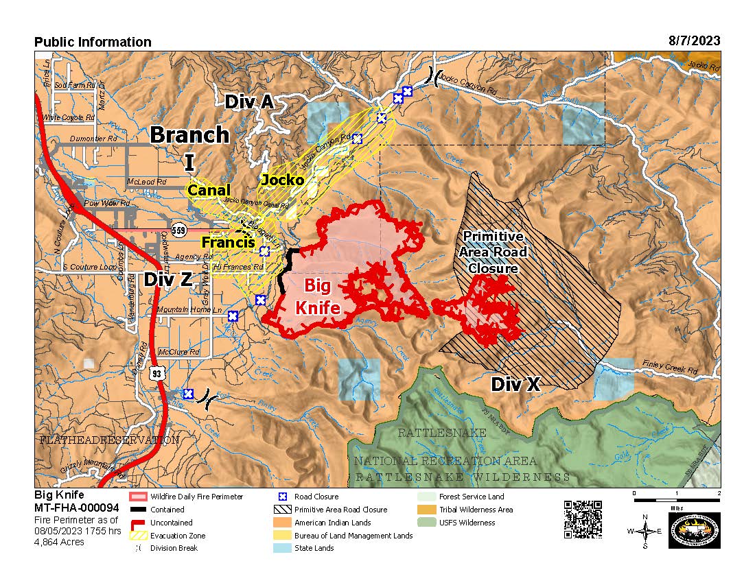
Big Knife Fire
Location: 5 miles east of Arlee
Size: 4,864 acres
Containment: 5%
Personnel: 329
Evacuation Warnings/Orders and Road Closures: The Lake County Sheriff has placed several areas near the base of the mountains west of the Big Knife Fire in PRE-EVACUATION status. See the attached map for specific locations. In the Tribal Primitive Area, Belmore Slough and Burnt Cabin Roads are closed. Drivers are encouraged to use extreme caution when driving on Highway 28. Authorities reduced speed limits to 45 mph due to poor visibility, and firefighters and equipment are still working in the area
Operational Updates: Heavy equipment operates completed a mastication line along the fire’s southwestern edge to reduce fuels and have begun mulching vegetation along Jocko Canyon Road. Firefighters are continuing to hold and improve a strategic firing operation to keep the fire north of Agency Creek. Structure protection crews are assessing structures in the Jocko Canyon area. Resource Advisors are assisting fire managers to ensure cultural and natural resource values are evaluated and protected during suppression activities.

Colt Fire
Location: 15 miles northwest of Seeley Lake
Size: 7,179 acres
Containment: 25%
Personnel: 515
Evacuation Warnings/Orders: There are currently no evacuations issued for this incident. Up-to-date evacuation information can be found on the Missoula County Sheriff’s Office Facebook page.
While Highway 83 is currently open, drivers are urged not to stop along Highway 83. Due to fire activity and smoke across the roadway, visibility is impaired, and traffic is increased, including emergency response vehicles, large equipment and law enforcement.
The Lolo and Flathead National Forests have closed several forest roads, areas, and campgrounds near the fire area, including:
- Forest Road 906 (closed at Highway 83)
- Rainy Lake Campground Access Road 4357 (closed at Highway 83)
- Rainy Lake Campground
- Alva Lake Campground Access Road (closed by gate at Highway 83)
- Alva Lake Campground
- Lakeside Campground Access Road (closed by gate at Highway 83)
- Lakeside Campground
- Forest Road 646 (closed at the junction of FSR 552; FSR 4354; Forest Road 552 (beyond the turn off to west side Lake Inez access)
- Forest Road 5507 and 463 closed beyond the West Side snowmobile trailhead (these roads access the Montana Fish, Wildlife, and Parks Marshall Wildlife Management Area and Lake Marshall)
- Temporarily closure of the Forest System Road loops of the Clearwater (FSR 4370 and 4353) and Richmond (FSR 667 and 720)
Operational Updates: Crews have been able to successfully “mop-up” residual heat from much of the fire’s northern and eastern edge. On the southwest corner of the fire, heavy equipment completed line construction up to Sunset Ridge, and crews scouted beyond Sunset Ridge to identify additional areas to continue line construction. While rainfall decrease fire activity, it also limited firefighting crews’ ability to access roads in certain areas of the fire. Crews will continue to “mop-up” remaining residual heat, construct line further along the fire’s southwest edge and construct handline above West Fork Clearwater River.

East Fork Fire
Location: 12 miles south of Trego
Size: 850 acres (information up to date as of Sunday at 6:12 p.m.)
Containment: 6%
Personnel: 130
Evacuation Warnings/Orders and Road Closures: A number of roads in the Kootenai National Forest are closed. See the below map for specific closures. Citizens are encouraged to avoid the area and give fire personnel room to work.
Operational Updates: The East Fork Fire is continuing to progress on all sides, and most aggressively towards the east. A small portion of the fire is now in the Tally Lake Ranger District. Coordination with the Flathead National Forest is occurring, and an official closure order for the fire area is being developed. Resources will continue to monitor the fire while equipment establishes an anchor on the fire and continues to construct indirect line and shaded fuel breaks around the perimeter. This will include flanking the fire from the east side of the fire and along Road #3530 from west to east.

Editor’s Note: This story has been updated to include new information about road closures due to the East Fork Fire.