Fire Managers Gain Ground on Ridge Fire as Forecasts Call for Hot and Dry Conditions
Additional resources have helped improve containment of the 3,132-acre fire outside of Hungry Horse while officials warn this week's high temperatures and low humidity will likely increase fire activity
By Maggie Dresser
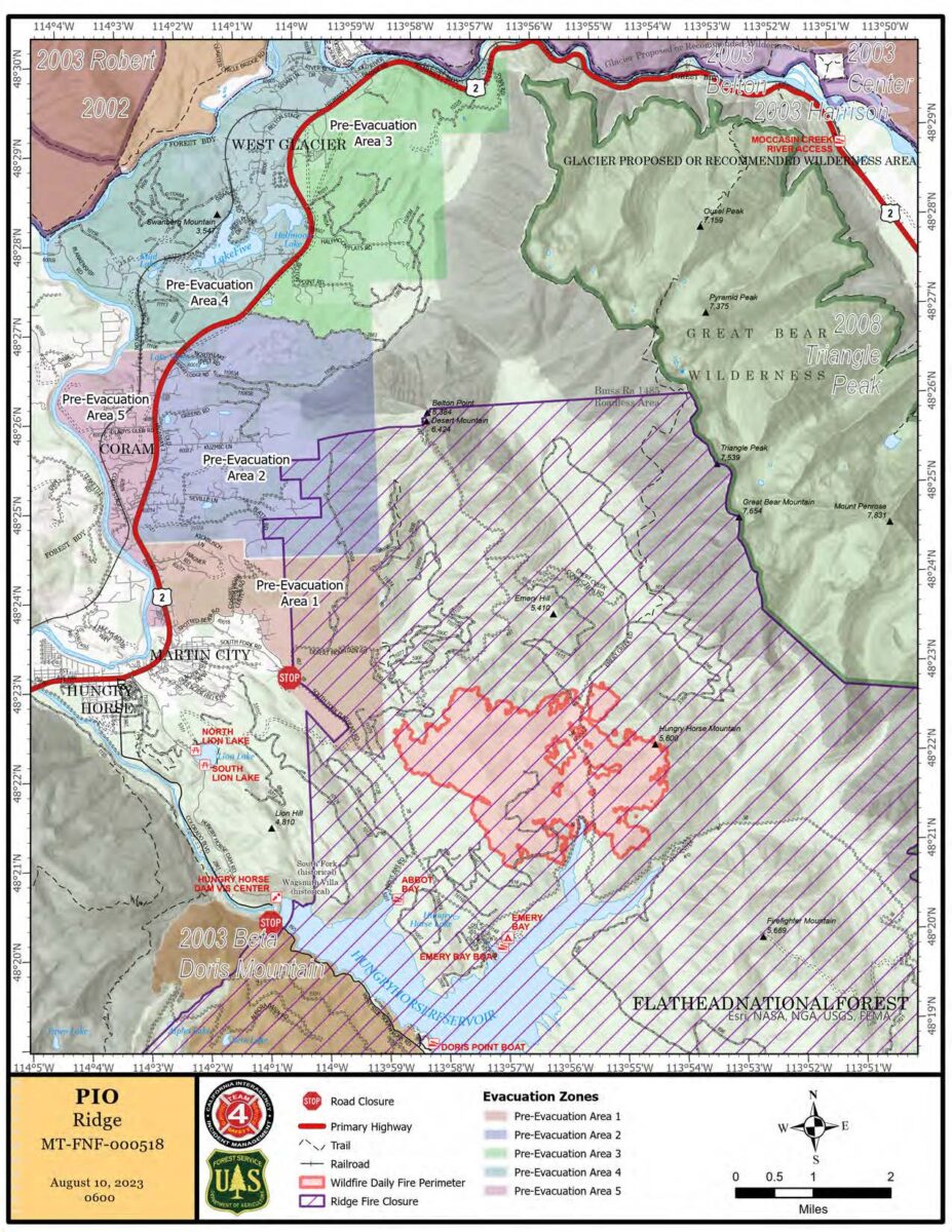
Following a productive weekend among firefighting crews tasked with managing the Ridge Fire southeast of Hungry Horse, the 3,132-acre wildfire is now 10% contained at the southern edge near Emery Bay Campground — a step up from the 0% containment rating last week.
Agencies have deployed additional resources in recent days to help contain the wildfire six miles outside of Hungry Horse. Last week, the California Interagency Incident Management Team 4 assumed control of the wildfire and fire managers have since brought in additional resources including hotshot crews, hand crews, engines, air tankers, helicopters and bulldozers.
“Crews are doing work and you will see that containment percentage go up over the next few days,” said Derek Tisinger, a spokesperson for California Interagency Incident Management Team 4.
Firefighters made progress yesterday with a handline that improved containment near the Emery Bay Campground and boat launch as they continued along the western edge. Teams pushed further into a designated experimental forest area called the Research Natural Area (RNA) near Desert Mountain, a swath of timber that’s set aside as a baseline for research purposes and does not receive wildfire mitigation treatments like prescribed burns or thinning. The dense fuel buildup presents challenges for fire line construction, Tisinger said.
“There are some unique challenges,” Tisinger said. “There’s no significant fire history in there and there are extremely thick and brushy conditions. Direct line construction takes longer because it’s thicker and it’s more hours of saw time.”
Fire officials said crews at the northern edge of the fire are progressing to the east with “great success” while there is increased smoke and fire behavior at the eastern edge. Aerial resources will continue to drop water on the eastern edge to slow the progress and a recently constructed heli-spot near Hungry Horse Mountain will provide additional access for fire crews.
“We will continue to use aviation assets to keep the fire in check,” Team 4 Operations Section Chief Drew Graham said.
As fire crews work to contain the Ridge Fire, officials warn that the hot and dry conditions predicted this week will likely cause an increase in fire and smoke activity. Temperatures are forecast to be in the mid-90s this week with relative humidities dropping into the single digits.
“It’s always a challenge, but we are preparing for it and watching for it,” Tisinger said. “We continue containment efforts, and we adapt based on what mother nature gives us.”
A pre-evacuation notice remains in effect from the east side of Spotted Bear Road to West Glacier.
The Hungry Horse Reservoir is closed to all public access, including both east and west side roads.
There will be a community meeting with members from the California Interagency Incident Management Team 4 at 7 p.m. tonight at the Glacier Bible Camp, 400 5th St. W. in Hungry Horse. The meeting will also be streamed on YouTube and Facebook.
At the Tin Soldier Complex, multiple wildfires continue to burn 17 miles east of Swan Lake on the Spotted Bear Ranger District. Of the four original wildfires in the area, the Con Kelly fire is now out while the Bruce, Kah Mountain and Sullivan fires are at 0% containment.
Crews are working to protect structures at the Spotted Bear Ranch, Diamond R Ranch, Spotted Bear Ranger Station compound and the Heinrude residential community.
Please note that the following reflects the latest information received at the time of publication. To see the latest updates for all major wildfires visit inciweb.nwcg.gov.
Major Wildfire Incidents
Ridge Fire
Tin Soldier Complex
Mill Pocket / Niarada Fire
Big Knife
Colt Fire
East Fork Fire
Ridge Fire
Location: 6 miles southeast of Hungry Horse
Size: 3,132 acres
Containment: 10%
Personnel: 481
Evacuation Warnings/Orders and Road Closures:
The Hungry Horse Reservoir is closed to all public access, including both the east and west side roads. The closure includes all roads, trails, and recreation sites in the area. The waters of Hungry Horse Reservoir and all islands are closed from Hungry Horse Dam to the Spotted Bear District boundary.
The following road closures are in effect:
- FS Road #38 (East Side Road #38) is closed to all public traffic east of the junction of FS Road #497 (Desert Mountain Road) and East Side Road #38.
- FS Road #895 (West Side South Fork Road #895) is closed to all public traffic starting at mile 15, near the Lid Creek Campground.
- West Side South Fork Road #895 from the Hungry Horse Dam Visitor Center to the existing closure at mile 15, near the Lid Creek Campground. Pre-evacuation notice in effect for private property along SF Abbot Creek on the west side of the fire.
- The Flathead County Sheriff’s Office has placed residents on the east side of Highway 2, north of Spotted Bear Road to West Glacier, under a pre-evacuation warning due to the growing threat of the Ridge Fire.
Operational Updates: Crews were able to contain 10% of the wildfire at the southern edge near Emery Bay Campground and Boat Launch. Crews will continue direct line on the southern edge of the fire and will progress west and north, extending further into the Research Natural Area near Desert Mountain and they will connect dozer lines on the northern edge. Air resources will continue to drop water on the eastern edge of the fire to slow its progression and assist ground crews. Structure protection assessments continue.
Additional Information: There will be a community meeting with members from the California Interagency Incident Management Team 4 at 7 p.m. tonight at the Glacier Bible Camp, 400 5th St. W. in Hungry Horse. The meeting will also be streamed on YouTube and Facebook.
Tin Soldier Complex
Location: 17 miles east of Swan Lake
Size: 2,694 acres
Containment: 0%
Personnel: 70
Evacuation Warnings/Orders and Road Closures:
The Hungry Horse Reservoir is closed to all public access, including both the east and west side roads. The closure includes all roads, trails, and recreation sites in the area. The waters of Hungry Horse Reservoir and all islands are closed from Hungry Horse Dam to the Spotted Bear District boundary. An area closure is also in effect for the front country of the Spotted Bear district, as well the Gorge Creek drainage within the Bob Marshall Wilderness area, including Feather, Inspiration, Gorge, Canyon Trickle, and Stadium Creeks.
The Flathead County Sheriff has ordered an evacuation for the Heinrude community.
A temporary flight restriction is in place for air space over the Tin Soldier Complex, including the Spotted Bear and Meadow Creek Airstrips, to provide a safe environment for firefighting aircraft operating in the area.
Operational Updates:
Structural protection efforts will continue today for the Spotted Bear Ranch, Diamond R Ranch, Spotted Bear Ranger Station compound and Heinrude community.

Mill Pocket / Niarada Fire
Location: 15 / 12 miles west of Elmo
Size: 2,135 / 20,365 acres
Containment: 89% / 70%
Personnel: 657
Evacuation Warnings/Orders and Road Closures:
The Lake County Sheriff’s Office is downgrading those in EVACUATION status near the Niarada Fire in Lake County to a PRE-EVACUATION WARNING. This area includes Alexander Road, Early Dawn Road, Spring Lane Road, Walking Horse Lane, Windward Heights Road, Wildhorse View, Buffalo Bridge Road, Saddle Drive, Island Butte Lane, Bridle Path, Ten Deuce Way, Cliffview Drive, and Ricketts Road.
A PRE-EVACUATION WARNING means that residents may return to their homes. However, as there is still a potential threat from the Niarada Fire, residents are encouraged to not bring back evacuated livestock until the area is downgraded to READY status.
The remainder of the town of Elmo is in READY status.
Drivers are encouraged to use extreme caution when driving on Highway 28. Though authorities have removed a modified speed limit, firefighters and equipment are still working in the area.
A temporary flight restriction (TFR) is in effect around the Niarada/Mill Pocket and Big Knife fire areas. Citizens are barred from flying unmanned aircraft (drones) near the fire areas, as it is hazardous for pilots, and firefighters on the ground who rely on aircraft support.
Operational Updates: Firefighters are working to reach containment near Highway 28 and crews continue to work directly along the fire’s edge to build fire lines.

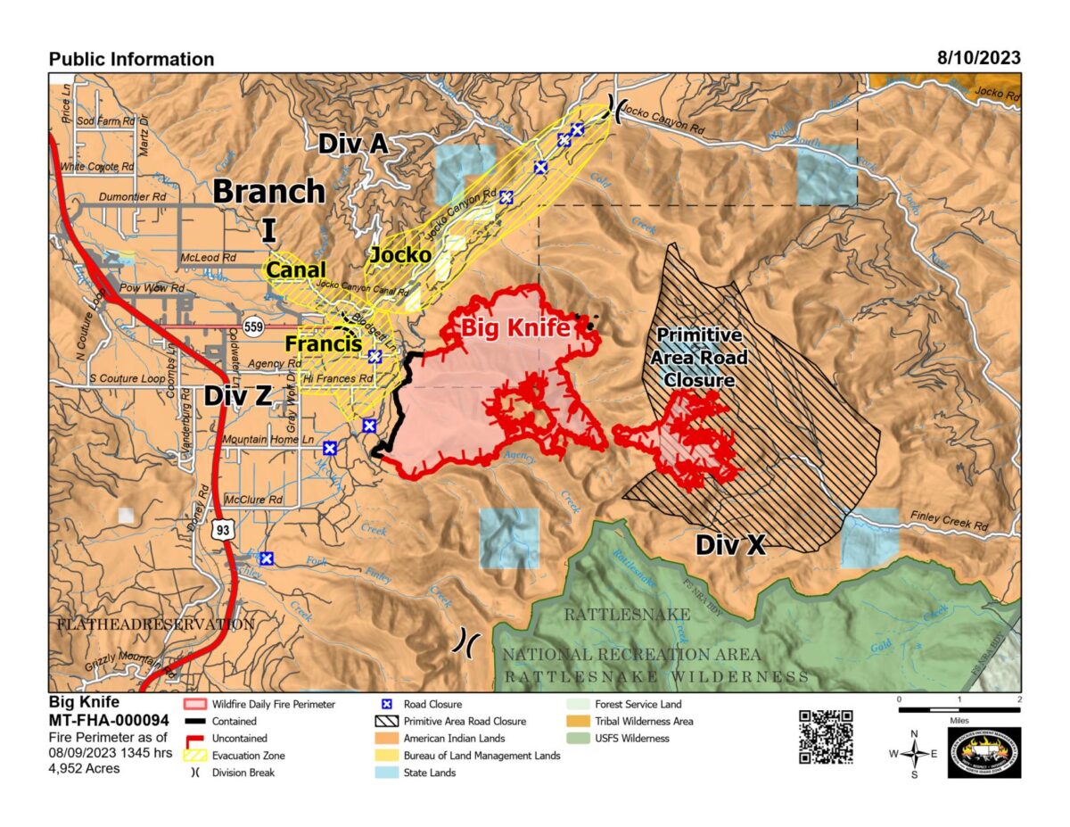
Big Knife
Location: 5 miles east of Arlee
Size: 4,952 acres
Containment:7%
Personnel: 657
Evacuation Warnings/Orders and Road Closures:
The Lake County Sheriff’s Office has placed several areas near the base of the mountains west of the Big Knife Fire in PRE-EVACUATION status. In the Tribal Primitive Area, Belmore Slough and Burnt Cabin Roads are closed.
A temporary flight restriction (TFR) is in effect around the Niarada/Mill Pocket and Big Knife fire areas. Citizens are barred from flying unmanned aircraft (drones) near the fire areas, as it is hazardous for pilots, and firefighters on the ground who rely on aircraft support.
Operational Updates: As hot, dry weather conditions persist this week, fire managers are continuing water drops to minimize spread into Gold Creek. Crews have completed a fuel break along the Jocko Canyon Road. Sprinkler systems and pumps were recently installed around several pieces of infrastructure and the Jocko Lookout.
Colt Fire
Location: 15 miles northwest of Seeley Lake
Size: 7,202 acres
Containment: 45%
Personnel: 562
Evacuation Warnings/Orders and Road Closures:
Numerous National Forest System (NFS) lands, roads, trails in the Swan Lake and Seeley Lake Ranger Districts of the Flathead National Forest and Lolo National Forest are closed to the public. See the map below for the specific closure areas.
All roads within the closure area boundary including but not limited to: NFSR #906, NFSR #646, NFSR #4356, NFSR #4354, NFSR #552, and NFSR #4349.
All trails within the closure area boundary including, but not limited to:
- Forest System Trail 34 (Jocko Trail) is closed from the Jocko Trailhead at Lindbergh Lake to the intersection of Forest System Trails 351 and 35.
- Forest System Trail 35 is closed from the intersection of Forest System Trail 34 to the Crystal Lake South Trailhead.
- The temporary flight restriction (TFR) for the fire area (FDC 3/7867) has been extended from 8 a.m.-10 a.m. to a full 24-hour restriction in order to provide a safe environment for firefighting aircraft operating in the area.
Lake Alva, Lake Inez and Rainy Lake campgrounds remain closed.
Operational Updates: Crews will continue to mop up areas along the fire’s perimeter, including heavy fuels along the fire’s southwestern edge. Firefighters will also continue to remove hoses and pumps from the fire line where they are no longer needed.
East Fork Fire
Location: 12 miles south of Trego
Size: 1,420 acres
Containment: 50%
Personnel: 250
Evacuation Warnings/Orders and Road Closures: A closure order is in effect for roads in the East Fork Fire area.
Operational Updates: Resources will continue to implement direct line, hose lays, and mop up operations. The fire will be transitioning to a new Type 3 Incident Management team on Wednesday, August 16th.