Pre-Evacuation Near Olney Ordered As East Fork Fire Grows
Hot, dry and windy conditions have increased fire activity in the Flathead and Kootenai national forests; Red Flag warning in effect through Saturday
By Maggie Dresser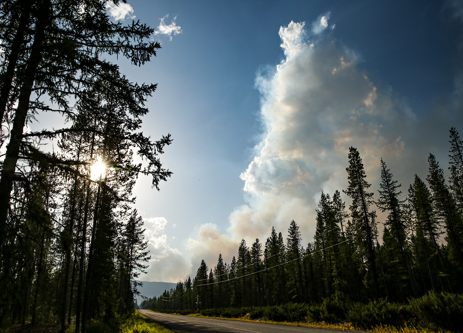
A pre-evacuation order has been issued for residents near Olney and the border of Flathead and Lincoln counties on U.S. Highway 93 after the East Fork Fire grew to 3,000 acres over the past few days amid a Red Flag warning.
A map of residences and a list of addresses within the pre-evacuation area can be found here.
“A pre-evacuation means the agencies involved believe there is a possibility of the fire spreading into the area,” according to a statement from Flathead County Sheriff Brian Heino, who issued the pre-evacuation warning. “This time allows residents the opportunity to make arrangements for their home, pets, livestock, and family in advance. Residents, landlords, hotels, and businesses in this area should also have a plan in place to evacuate should the need arise.”
Officials say high temperatures, low humidity levels and gusty winds have led to the fire’s expansion and a Red Flag warning is in effect through Saturday in the region. Fire crews report the fire is 20% contained and plan to continue holding it in check, with mop-op actions on the west and south sides of the East Fork Fire to protect structures and values at risk.

A Complex Incident Management Team will assume full command of the East Fork Fire tomorrow and will bring in additional resources to help prevent the fire’s spread.
The East Fork Fire was detected on the Fortine Ranger District on July 30 on a ridge just west of the East Fork of Sunday Creek and 12 miles outside of Trego. An aggressive Initial Attack combined with air resources were utilized when it was discovered, but recent weather conditions have caused the fire to grow.
Lincoln and Flathead Counties, Montana Department of Natural Resources, Bonneville Power, Montana Department of Transportation, and Burlington Northern Railroad cooperators have been engaged to provide information and their involvement in any actions necessary to protect structures and infrastructure, including emergency actions for public safety.
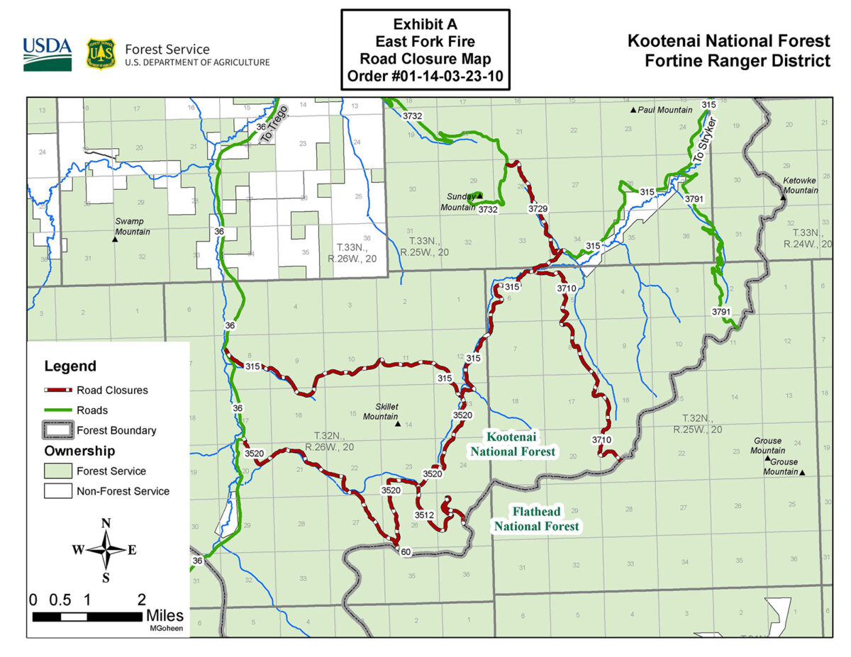
A closure order is now in effect for roads in the East Fork Fire area. Please view the closure order and map for more information.
The increased fire activity in the region has also prompted the California Interagency Incident Management Team 4 to assume control of the Tin Soldier Fire, which has spread to 5,966 acres and includes the Sullivan and Bruce fires, burning east of Swan Lake.
Today, firefighters will continue reducing fuels and begin to implement sprinkler systems near threatened structures at commercial guest ranches, the Spotted Bear Ranger Station compound and the Heinrude residential community.
The Flathead County Sheriff’s Office has issued an evacuation order for the Heinrude community.
Team 4 also assumed control of the Ridge Fire burning outside of Hungry Horse and the Doris Point Fire on the west side of the Hungry Horse Reservoir.
The Ridge Fire is 20% contained while the Doris Point and Tin Soldier fires are 0% contained.
Forecasters predict windier conditions today with gusts up to 30 miles per hour in the valley and 40 mile per hour gusts on ridges and upper slopes and increased fire activity is expected.
On the Ridge Fire, the eastern edge of the fire has grown and firefighters are continuing to directly attack the fire with aviation resources.
The Doris Point Fire is now estimated to be 579 acres after more accurate mapping was conducted. Fire personnel and Flathead National Forest officials are completing a structure wrap while installing sprinklers to protect campgrounds and boat docks near the Hungry Horse Reservoir.
“The fire grew a little bit yesterday and crews were engaged in structure protection and infrastructure for the campgrounds down on the West Side Road,” California Interagency Incident Management Team 4 Operations Chief Drew Graham said in an Aug. 18 update. “Crews will be monitoring the fire today and will be able to engage if there are any concerns.”
A cold front is expected to move into the region this weekend, bringing a 30% to 40% chance of rain on Monday and Tuesday and high temperatures dropping to the 70s and 80s in the next week.
The Hungry Horse Reservoir is closed to all public access, including both the east and west side roads. As firefighting efforts continue on the Ridge Fire, the Tin Soldier Fire, and other fires in the area, the closure is in place to provide for public and firefighter safety.
There will be a community meeting with members from the California Interagency Incident Management Team 4 at 7:30 p.m. tonight at the Glacier Bible Camp, 400 5th St. W. in Hungry Horse.