River Road East Fire Has Destroyed 55 Structures, 15 Primary Residences
The River Road East Fire, located about 6 miles east of the town of Plains, began burning the afternoon of Aug. 18
By Mike Kordenbrock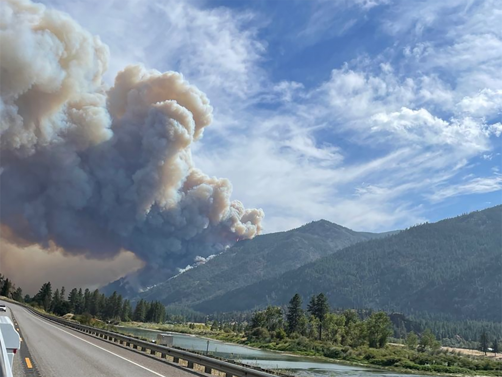
The River Road East Fire burning about six miles east of Plains around the community of Paradise is believed to have destroyed 55 structures, including 15 primary residences, Sanders County Sheriff Shawn Fielders said Thursday night at a public meeting at the Plains High School Gym.
Generally speaking, the sheriff said that other types of structures included in the total count include anything from an outbuilding to a house. At a meeting earlier this week, the sheriff had indicated that some structure losses had been confirmed in the McLaughlin Creek area. Officials currently list the fire’s cause as undetermined.
On Friday, the fire was reported to be 17,098 acres in size, and 7 percent contained, with a total of 671 personnel assigned to it. The River Road East Fire is burning in mixed fuels, including timber and brush.
“It’s a lot, but it could have been far, far worse.” Fielders said. “My heart goes out to those that lost parts of their properties, and their homes, and whatnot. But again, I’ve never seen anything like these firefighters. They threw everything at trying to save as many structures as possible.”
James Russell, the fire chief for the Plains-Paradise Rural Fire District, said that as he was driving through town last Friday when the page went out for smoke near Highway 200 and River Road East. He saw the smoke and knew that firefighters would have a challenge ahead of them.
“When I got there the fire was progressing very quickly. You guys saw the wind that day,” he said.
Firefighters worked “immediately” to begin protecting structures, the fire chief said, and he praised the coordination of firefighting resources, as well as the efforts of firefighters from surrounding counties and neighboring communities that answered the call for mutual aid that night.
“Thankfully, with that rain event that came, a lot of progress was made. I just want you to know, that it is true, it helped a lot. But it didn’t just stop with the rain,” Russell said.
Members of the incident management team were careful not to close the book on this incident.
Jonathan McGee, the meteorologist producing forecasts for the incident management team, shared a poster during the meeting that shows daily highs Saturday through Tuesday ranging between 91 and 95 degrees, which he said is anywhere from 10 to 15 degrees above normal for this time of year.
Of the rainfall earlier this week, McGee said the fire area on average saw between an inch to an inch-and-a-half of rain as the remnants of Hurricane Hilary pushed through the area.
“Just to put that in perspective, climatologically speaking, in this area in the month of August, you get about an inch to an inch-and-a-quarter of rain. So you got most of your monthly rainfall total for August in a 36-hour period.”
McGee said there was a chance of some limited rainfall Friday afternoon, and that there are increasing probabilities for a rain event Wednesday into Thursday of next week. But he said that it’s unlikely that rain will be anywhere close to what was seen at the start of this week.
The more long-term trends for the area throughout the fall are less encouraging. Bryan Anderson, a fire behavior analyst with the Northern Rockies Complex Incident Management team working the fire, said that “the bad news” is that the second part of September looks to be trending on the hotter and dryer side. Three-month forecasts going into November show the same thing, what Anderson called “a hot and dry fall.”
Not all of the area impacted by the fire has burned, leaving some unburned fuels that the fire may spread into as warm and dry conditions persist.
Still, there is belief that significant progress was made on the firefighting effort thanks to a combination of ongoing efforts by firefighters from multiple agencies and jurisdictions.
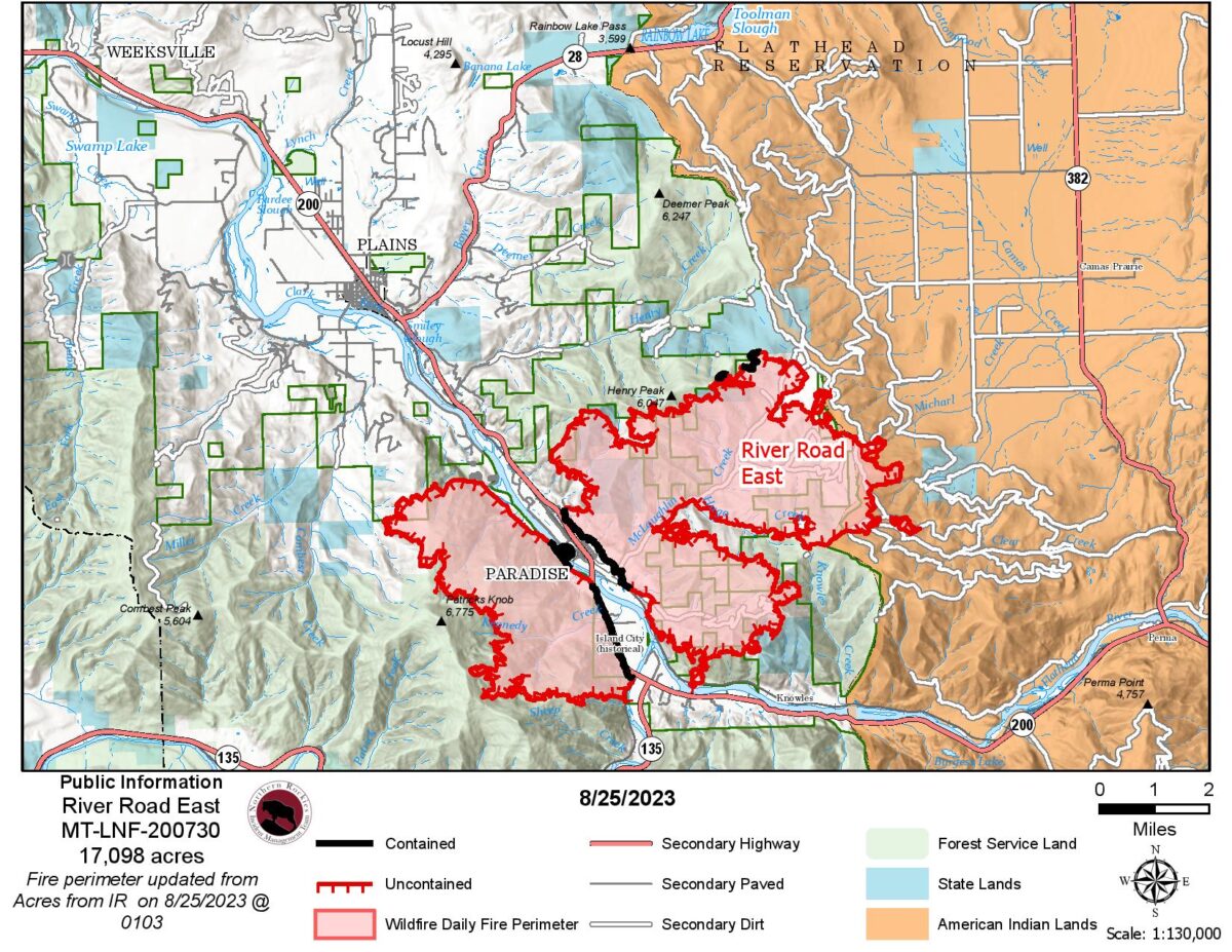
Justin Kaber, the operation section chief with the incident management team, said in an operation update midafternoon Thursday that crews had put fire line from Henry Creek all the way east to the Flathead Indian Reservation boundary line, and all the way south to the Clear Creek Road area.
“We estimate there’s about 69 miles of line that needs to be constructed around this incident,” Incident Commander Brent Olson said. “As you know, that’s line that is in some of the most rugged country that we could ever fight a fire (in). Very steep, very broken, and it’s not going to be easy for anybody to get around in. But having said that, I would estimate that we’re close to having constructed line on maybe 35 percent, 40 percent, of this incident. That’s a lot of work that’s been done in very short order.”
The benchmark for containment, he said, is not just having line on the ground, but firefighters having gone in some distance from the fire edge, sometimes 100 feet or further, and “mopped it out.”
“We’re trying to make sure the potential for the fire to move beyond that edge is as close to zero as possible,” he said, adding that it takes time.
Olson said that going forward the team recognizes the ongoing potential for more wind, and what that could do.
“Wind is the wild card,” he said. “There is enough flame and there is enough open heat that’s still out there that needs our attention to make sure that we take care of that perimeter to not allow additional fast-moving fire growth out of this incident.”