Just after midnight on Sept. 23, summer officially ended in northwest Montana. It might have been a long hot summer, but for some, it will never be long enough.
If you find your spirit falling with the leaves as summer ends, look around and you might find a reason to celebrate. It sure looks like Mother Nature is throwing a party, complete with colorful décor.
The fall festivities are well attended by tourists of a different kind, with the stopover of migratory birds following the sun’s path south. Starlings put on an air show with the spellbinding synchronized dance known as murmuration and waterfowl fly overhead in elegant V-formations. Live music is provided with the honks and quacks of waterfowl overhead and on the surfaces of lakes and wetlands that speckle the valley floor. The staccato calls of raptors punctuate the freewheeling concert.
This splendid season often includes a batch of warm weather and bluebird days that make it look like you used filters to enhance your fall photos. The celebration builds as the landscape explodes with burning hot colors reminiscent of a 4th of July fireworks show – summer’s grand finale.
Northwest Montana has some of the most stunning scenery anywhere, of course, but the fall color adds a flamboyance to a place that’s already pristine; from where the sprawling farmlands meet up with majestic mountains in the Flathead and Mission Valleys, to the verdant Swan corridor tunnel that is tucked in between two mountain ranges.
Here are six different regions of Northwest Montana and what makes them unique – and what is unique to them in the fall.
Glacier National Park
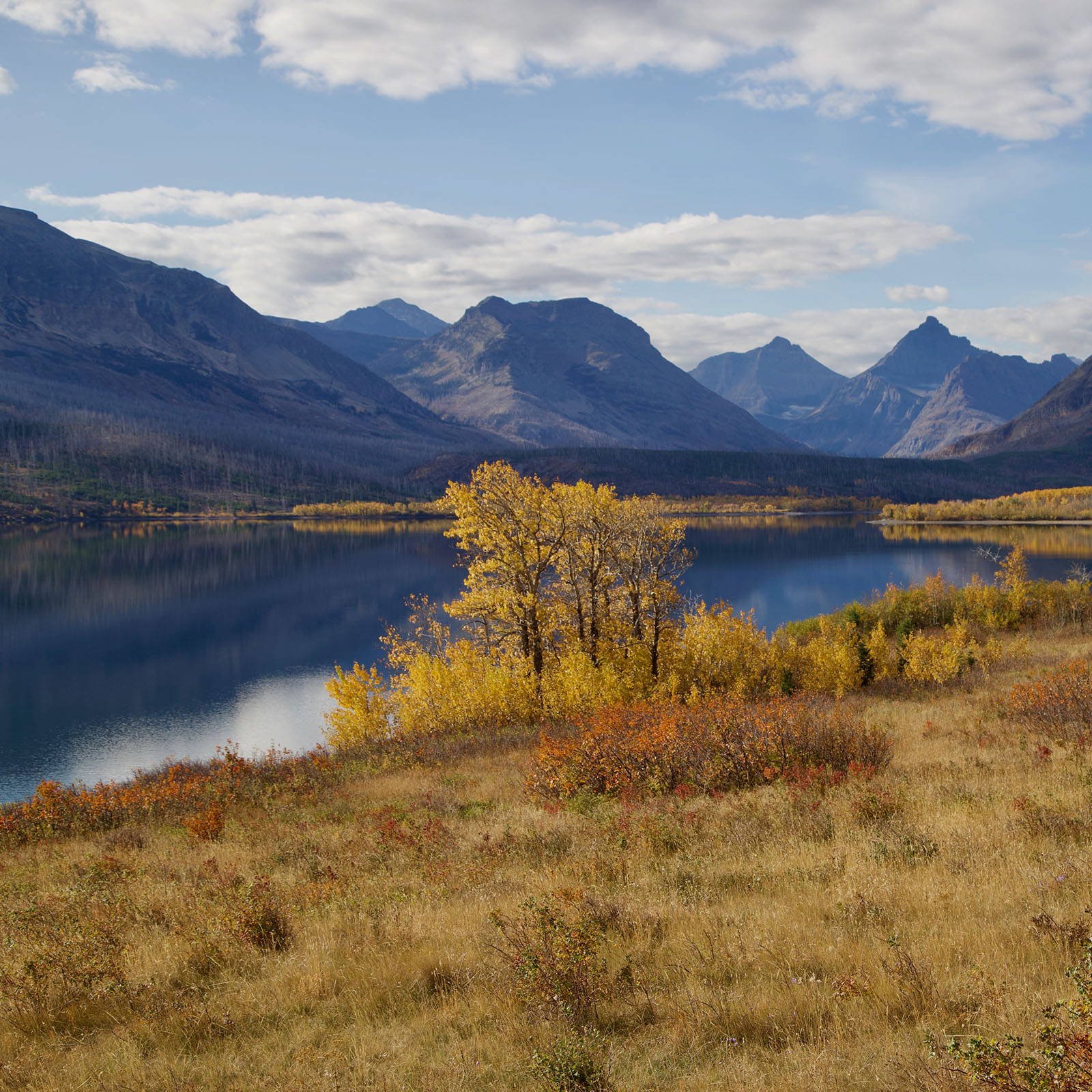
As the busy season quiets down in Glacier Park, fall turns it up – on the west side in mid-September and on the east side, a few weeks later. All lodging and most concessions are closed by the end of September, but the quietude creates a unique time to visit with the subsequent drop in visitation and traffic.
The breathtaking beauty of Glacier National Park grows even bolder and brighter during the fall season. It is also an active time for wildlife preparing for winter. Hawks, golden eagles and other raptors follow a major migration route along the Continental Divide in Glacier. You can drive to Logan Pass to take a hike or simply linger at the top to try to spot these majestic birds. The surrounding meadows of alpine shrubs and wildflowers pop with color amid faded grasses.
Plan this trip for earlier fall because even though the upper reaches of the Going-to-the-Sun Road typically close the third Monday in October, the scenic alpine highway can close earlier due to snow. Capture great views while traveling along Lake McDonald, as well as sweeping views of the peak-studded park and its fall colors, as you wind up the Going-to-the-Sun Road. Construction will continue in Glacier during the fall, so check their website for current road information: https://www.nps.gov/glac/planyourvisit/projectwork.htm
Enjoy views from the other side by driving up the Middle Fork of the Flathead River on U.S. Highway 2, which runs along the southern border of Glacier Park. At Marias Pass and in other sections of East Glacier you can find groves of twisty aspen with leaves fluttering like golden coins. They are prevalent in the lowlands where they are protected from the drying winds that are common in this area. This is also a good place to see larch trees as they torch the hillside with their bright yellow color and the bright reds of huckleberry bushes.
Further down the road you reach East Glacier, where fall foliage includes yellow aspen, cottonwood and larch along with the oranges and reds of a variety of vegetation that decorate the shoreline of St. Mary Lake and Two Medicine Lakes.
Nature Note
An entire aspen grove may share a single root structure.

The North Fork
The North Fork of the Flathead River is a federally designated Wild and Scenic River that is surrounded by open meadows, grasslands and majestic glaciated mountains. Past wildfire has created a landscape that is marked with tree skeletons that allow glimpses of the surrounding mountains and sunlight for shrubs and trees that are rejuvenating to the landscape.
There are two roads leading to this wild and wooly place, but the Inside North Fork Road will be closed Sept. 11 through mid-November for construction, preventing access to Bowman and Kintla Lakes in Glacier National Park.
The outside North Fork Road is a more direct road to the Ranger Station and the entrance to Glacier – and to the iconic Polebridge Mercantile, which stands out in history and in the tiny community of Polebridge. The red false-front facade building was built in 1914 and is now home to a popular bakery and deli, probably most famous for their huckleberry bear claws. Also notable is its neighbor the historic Northern Lights Saloon and Café, which features local beers and a menu that includes food made from locally sourced products. Polebridge is completely off the grid without cell service, internet or electricity, forging an old-fashioned hospitality and sense of community.
Much of the North Fork Road is gravel, which slows down traffic (and development) in this wild corner of the state. The road winds along the North Fork of the Flathead River through old fire sites that are blanketed with colorful ground cover such as the bright orange mountain ash, red huckleberry bushes, yellow-needled larch and shrub-like mountain maples (which provide food for elk and moose in the winter).
Nature and Nurture
North Fork Preservation Association (NFPA) was established by locals in 1982 in response to development initiatives that would have altered the natural area forever, including the proposed development of a coal mine upstream in Canada and pressure to pave the road. The mission of the NFPA “is to champion the exceptional biodiversity and wildness of the North Fork of the Flathead River watershed.”

Swan Valley
Hugged by the Mission Range to the west and the Swan Range to the east, the Swan Valley is a narrow valley with vast stretches of forested and mountainous public lands, leaving less room for human development and more room for wild places and wildlife. Solidifying its wildness are the Mission Mountain Wilderness composed of 74,525 acres to the west and the Bob Marshall Wilderness to the east, which spans over 1 million acres in the high country that extends for 60 miles.
The deeply forested area is also abundant with water, including the Swan River, which flows through the two mountain ranges, originating high in the Mission Mountains at Gray Wolf Lake. From there it descends into Lindbergh Lake and flows east briefly before bending north and flowing 75 miles to Swan Lake. At the north end of the lake, the river continues into the Flathead Valley, wending through a canyon where it gets rowdy and rough below the dam for a “Wild Mile” before emptying into Bigfork Bay.
As you travel down the Swan corridor, you will be a stone’s throw from more than one dozen lakes that lie in the valley, including Seeley, Salmon, Inez, Alva and Swan. Also interspersed across the valley floor are diverse wetlands that include marshes, vernal ponds, sedge meadows and peatlands. A diversity of plant life ranging from grasses to willows and thornapple color the landscape as they begin to turn in early September, with the yellow cottonwood and aspen joining in later in the month. Late to the party, the larch trees turn bright yellow in mid-October and light up the predominantly evergreen forests that rise from the valley at the base of the rugged mountains. (The larch is unique in that it is a deciduous conifer that loses its needles in the fall.) This beautiful light show doubles its magnificence when it is reflected on one of the many waterways.
There are a number of pullouts along the way where you can get views of the mountains and possibly spot area wildlife. Elk often are seen along the valley floor in the fall during mating season. Deer are probably a lot less thrilling to see because of their number and the number of collisions caused – something to keep in mind as you travel Montana Highway 83. A pullout at mile marker 57 showcases the stunning 9,289-foot Swan Peak, one of the few places in the Bob Marshall Wilderness with an active glacier.
Naturally Impressive
Swan Valley Connections is a nonprofit organization located in the tiny community of Condon whose mission is “to inspire conservation and expand stewardship in the Swan Valley.” They collaborate with over 20 agency partners to achieve collective conservation goals in the Swan Watershed. Visitors are welcome to stop in at their office, which includes maps, books and nature and historical displays.

North Shore Flathead Lake
The seven miles of Flathead Lake shoreline is mostly undeveloped and, thanks to the conservation efforts of many groups and former landowners, will remain that way into perpetuity.
There about 2,400 acres along the north shore that are protected by a variety of state and federal lands as well as private conservation easements. Dominated by wetlands and fields, this area is a crucial refueling stop for tens of thousands migrating waterfowl and shorebirds in the fall and spring each year. Over 229 species of birds have been documented to use this area, which was declared an Important Bird Area by the National Audubon Society and is a part of the Flathead Lake Waterfowl Production Area.
There are several places offering public access, including the Flathead Lake Waterfowl Production Area located on Somers Road; the North Shore State Park, which showcases a 70-acre spread located east of the Flathead Lake Waterfowl Production Area; and Somers Beach State Park, which was acquired by the Montana Fish Wildlife & Parks in 2021. Somers Beach State Park borders the Flathead Lake Waterfowl Production Area and offers access to 106 acres along a sandy beach during periods of low water from fall to spring.
North shore access areas are closed to the public from March 1 to July 15 during breeding, nesting and brood-rearing seasons. The fall is a great time to observe flocks of birds, ducks and swans gathering on the north shore.
The big expanses of grasslands, wetlands and shoreline become more colorful in the fall with yellow cottonwood and willow trees, the oranges and reds of the Douglas hawthorn and red osier dogwood that are in striking contrast to green- and sand-colored grasses.
Flathead Fact
Flathead Lake is touted to be the largest freshwater lake in the Lower 48, in total surface area, west of the Mississippi; however, because of its overall depth, Lake Tahoe has more water than Flathead Lake.

Mission Valley
The Mission Valley’s dramatic landscape includes Flathead Lake and the spectacular Mission Range with 10,000-foot peaks that grow larger and craggier as you venture south. Home to the Flathead Indian Reservation and the Salish, Kootenai and Pend d’Oreille people, the Flathead Indian Reservation spans 1.25 million acres. You can learn about the history and culture of the Mission Valley at The Three Chief’s Cultural Center Gift Shop & Museum in Pablo and The Ninepipes Museum of Early Montana in Charlo.
Dominating the landscape are the towering Mission Mountains. The Mission Mountain Tribal Wilderness was officially established in 1982, making it the first tribally managed wilderness area. This 89,500-acre wilderness butts up to 74,525 acres of Mission Mountain Wilderness on the east side of the Missions.
In the fall, tawny fields and grasslands glow in the sunshine accented by yellow cottonwoods, orange willows and colorful red shrubs that lie along creeks and rivers.
Formerly known as the National Bison Range, the Bison Range near Moise, is at the center of the reservation and is currently managed as a wildlife refuge by the Confederated Salish and Kootenai Tribes (CSKT). The hundreds of bison here are descendants of the free-range bison herd restored to the area in the 1800s by tribal members when the bison were near extinction.
Summer hours continue through October with access to Red Sleep Drive and Buffalo Prairie Drive. Fall is a great time to observe the iconic bison and other wildlife including bighorn sheep, deer and antelope.
Check their website for details: https://bisonrange.org
A Wild Idea
In the 1930s, the National Park Service considered including the Mission Mountains in a proposed national park unit.

Jewel Basin Hiking Area
This hikers-only area offers 35 miles of trails winding through over 15,000 acres sprinkled with nearly 30 gem-like lakes.
The popular hiking area sees heavy use in the summer season because of its proximity to the Flathead Valley population and seasonal visitors, combined with the boost of a high elevation parking lot that can get hikers to alpine lakes or the summit of Mount Aeneas in two hours or less.
Use decreases in the fall, offering less crowded trails and parking lot. You can also access the Jewel Basin from the Hungry Horse Reservoir area where the trails are wilder and more solitary due to lighter use. Hunting is allowed in this area.
The shimmering Jewel Basin lakes are surrounded by a patchwork of color on mountain slopes and meadows are sewn with huckleberry bushes, fireweed and mountain ash.
For the Birds
If you venture to Mount Aeneas, you might see volunteers collecting scientific data for the Jewel Basin Hawk Watch, a program that monitors raptor bird migration in the fall each year. Observations includes bird species, sex, age, morph, color, as well as weather conditions when spotted. Daily tallies are posted at the trailhead.