Flathead Forest Aims to Balance Snowmobile Suitability with New Restrictions, Access
A proposed amendment to the Forest Plan would designate about 12,588 acres as open to over-snow vehicle use while closing an additional 12,258 acres, including near the southwest end of Hungry Horse Reservoir; bicycles would be prohibited in recommended wilderness areas
By Tristan Scott
Federal land managers are seeking the public’s input as they revise the 2018 Flathead National Forest Plan, proposing to swap land-use designations for over-snow vehicle use by declaring certain areas as suitable to motorized activities such as snowmobiling while offsetting the loosened restrictions by prohibiting those activities in other areas, including recommended wilderness zones where they’re currently allowed.
The changes to winter travel management on the Flathead National Forest would require an amendment to the 2018 Forest Plan, which identifies 743,949 acres, or 31% of its jurisdiction, as suitable for over-snow vehicle use. It also identified about 190,000 acres of National Forest System lands as recommended wilderness areas which are suitable for potential inclusion in the National Wilderness Preservation System. Only an act of Congress can designate new wilderness.
Forest officials say the proposed changes could result in an increase in access for over-snow vehicle use on 12,588 acres across the 2.4-million-acre forest, while limiting access on 12,258 acres.
The balancing act is part of a directive issued when the revisions to the land management plan were signed on Dec. 24, 2018, requiring the agency “initiate site-specific planning … within three years from the date of this decision where an existing order may need to be changed (e.g., changes to snowmobile use per the current over-snow vehicle motor vehicle use map) or where an order may need to be issued, (e.g., to prohibit mechanized transport).”
The proposed suitability changes to winter travel management and recommended wilderness areas on the Flathead National Forest are detailed in an environmental assessment (EA) released earlier this month for public comment.
The Flathead National Forest’s footprint includes the Whitefish Range, the Swan Range and the Mission Mountains, and agency officials are engaged in a constant juggling act to balance priorities like recreation, timber, fire, resource conservation, safety, and education.
The 2018 Forest Plan (implemented in 2019) replaced the 1986 plan, updating the U.S. Forest Service’s long-term strategic vision for managing the network of lands in northwest Montana. The Flathead Forest Plan is the second in the nation to use the Forest Service’s 2012 Land Management Planning Rule, which facilitates goals of the U.S. Department of Agriculture in promoting sound land stewardship in partnership with communities.
Among its many proposals, the forest plan recommended new land for inclusion in the National Wilderness Preservation System, including the Jewel Basin, the Tuchuck-Whale areas and additions to the Mission Mountain, Great Bear and Bob Marshall wilderness areas.

When a forest plan identifies an area as not suitable for an activity, such as mechanized activities like mountain biking or motorized use like snowmobiling, the plan has no immediate effect on the public. This is because changes in suitability allocations in the forest plan are programmatic in nature and do not change any site-specific public uses until second-tiered, site-specific planning takes place, according to forest officials.
The project proposes to update the motorized over-snow vehicle use map to designate or prohibit motorized over-snow vehicle use in those areas where the 2018 Forest Plan made changes in motorized over-snow vehicle use suitability; prohibit motorized use and mechanized transport (mountain biking) in recommended wilderness areas by issuing a long-term forest closure order; and clarify the forest plan direction in recommended wilderness related to mechanized and motorized uses for administrative purposes.
The proposal would prohibit the use of mechanized transport, such as bicycles, and motorized use in recommended wilderness areas. Of the 190,328 acres of recommended wilderness areas, about 95 miles of trail currently allow mechanized transport and about 383 acres currently allow over-snow vehicle use.
“We propose to prohibit public use of mechanized transport and motorized use in recommended wilderness areas through a forest order,” the EA states. “This means the public could no longer use mechanized transport in recommended wilderness areas where this use is presently allowed, nor other motorized uses (such as chainsaw use). However, the public would still be able to use all these trails via unmechanized transport or unmotorized use, for example, hiking, horseback, snowshoeing, or skiing.”
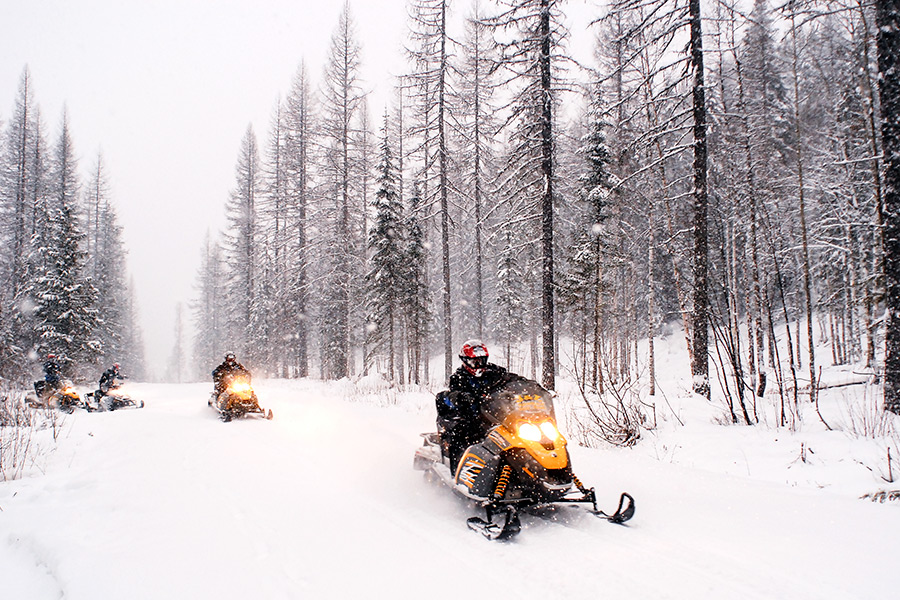
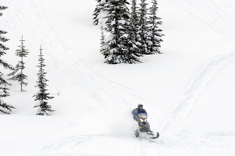
An over-snow vehicle is defined by the U.S. Forest Service as “a motor vehicle that is designed for use over snow and that runs on a track or tracks and/or a ski or skis while in use over snow.”
In addition to reducing conflict and balancing out recreation on the forest, the proposed closures are aimed at protecting threatened and endangered wildlife species, including Canada lynx and wolverine, as well as to align with the Flathead National Forest’s whitebark pine restoration strategy and achieve so-called “desired forest conditions” identified in the 2018 revised forest management plan.
The acreage that forest planners would open to over-snow vehicle use spans the Tally Lake, Glacier View and Hungry Horse ranger districts, including 11,361 acres in the Upper North Fork, Canyon and Big creeks, as well as in the Marias Pass and Skyland Challenge areas. The changes would prohibit OSVs on portions of the Hungry Horse and Spotted Bear ranger districts that currently allow them, including 11,597 acres in the Puzzle Creek, Upper Sullivan and Upper Tin areas.
The changes include a proposed winter OSV closure of the route up Puzzle Creek in the Skyland Challenge snowmobile area east of Essex, which forest planners said would limit illegal riding in the Badger-Two Medicine area. This portion of Puzzle Creek is now part of the Slippery Bill-Puzzle recommended wilderness area.
Suitable acres in the Canyon and Big Creeks and Skyland Challenge areas were substituted for acres in the Sullivan drainage that has more difficult terrain to ride but provides quality habitat for Canada lynx.
Over-snow vehicle use would be allowed from Dec. 1 to March 31, matching existing over-snow vehicle use timeframes on most of the forest, in all the areas proposed to be designated as suitable to OSV use. In the upper Middle Fork portion of the Hungry Horse Ranger District, the Marias Pass, Skyland Challenge, and Elk Calf Mountain areas would be open to over-snow vehicle use from Dec. 1 to May 14.
The proposed changes to OSV use have drawn a mix of support and opposition, with OSV users calling the addition of closures unnecessary.
“I ABSOLUTELY am against any over the snow and mechanized use closures. Especially Puzzle Creek and Slippery Bill areas, and all the other snowmobiling around Hungry Horse,” Hayden Smith wrote in a public comment. “You people have already taken away some of the best snowmobiling in Montana from PUBLIC LAND OWNERS. You forget that we pay your wages and you work for the people and it’s time you stop shutting us out! By closing traditionally used snowmobile grounds all you will do is piss people off and people will have enough and start cutting locks and not respecting closures. Your end goal is catering to special interest environmental groups and we are sick of it! No more closures AMYWHERE and open up all the land you have already taken away from us. I have ridden these areas you plan to close for 20+ years and hope to one day show my son the same places I’ve been able to enjoy. Don’t take that away from him and don’t take those memories away from me!”
Other forest users welcomed the proposed closures, particularly as land managers document increasing illegal use in the Badger-Two Medicine area, which riders access from the west side of Marias Pass.
Among the public comments collected by land managers so far, Paul Bechtel wrote that he supports the proposed winter closure of the route up Puzzle Creek in the Skyland Challenge snowmobile area “as this will limit illegal riding in the Badger-Two Medicine and protect mountain goats and other wildlife.”
“However, the new boundary should be near the Morrison Creek bridge where the warming hut and bathrooms are located as this will be a more effective, intuitive, and enforceable boundary,” according to Bechtel’s comment.