Northwest Montana Continues to See Smaller Wildfires Across Region
A half-dozen blazes continue to burn in the region, all less than 200 acres; incoming wet weather expected to mitigate fire conditions
By Micah Drew
Firefighting crews across myriad agencies are battling a handful of small blazes across northwest Montana, with incoming rainstorms expected to help mitigate wildfire conditions.
The Confederated Salish and Kootenai Tribes (CSKT) Division of Fire announced Monday morning there are three actives fires burning on the Flathead Indian Reservation where fire danger remains extreme. All three fires resulted from lightning strikes and as of July 29 there are no closures issued near any of the blazes and no structures are threatened.
The largest fire is the 153-acre Mill Pocket fire 20 miles west of Elmo, where CSKT crews and engines are working to suppress the blaze and have reported 10% containment.
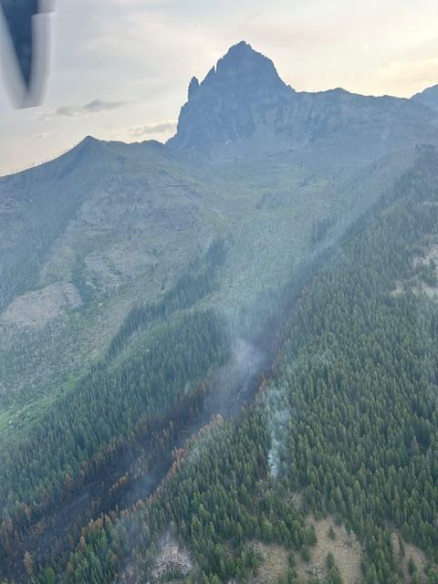
The Haymaker Fire is burning in steep terrain with thick, dense timber six miles southeast of Polson in the Mission Mountains. A Type II helicopter dropped on the fire yesterday and will be used as needed throughout the day.
The Sullivan Fire, located eight miles northeast of Hot Springs, is 40% contained with miscellaneous overhead resources and two dozers working the fire.
A️cross the Flathead National Forest, two new fires were reported over the last few days. On July 26, the Silvertip Fire was detected in the upper Silvertip Creek drainage of the Bob Marshall Wilderness. The fire is believed to have been caused by lightning and was estimated at one-tenth of an acre. Three firefighters from the Spotted Bear Ranger District hiked to the fire’s location over the weekend and reported it as controlled and out on Sunday.
The Holland Peak Fire was detected on July 27. It is also believed to be a lightning-caused fire burning on a northwest aspect above 6,000 feet in the Cooney Creek drainage. An air attack and helicopter rappel crew responded to the fire but were unable to insert firefighters on the ground due to safety precautions. Fire managers are developing a suppression strategy based on protecting critical values at risk, according to an agency press release. They are working to identify areas to establish containment lines that will have the highest probability of success in containing the fire, while reducing risk to responders and the public.
In Glacier National Park, the Muir Creek Fire, reported last week, remains estimated at 30 acres burning southwest of Mount Saint Nicholas. A local Type 3 Incident Management Team is preparing a strategy to confine the fire within Glacier National Park, protect structures and infrastructure, and plan for future fire suppression in the event that fire activity increases. The fire is burning in very steep terrain with timber and heavy dead and down fuels, offering the potential for increased activity if temperatures increase and winds align with the topography.
Over the weekend, fire managers monitored the blaze from the ground and air. Packers staged structure protection materials at National Park Service patrol cabins and the Scalplock Fire Lookout in case the structures require protection in the future.
There is an area closure in place northeast of the Fielding Trail, southeast of the Coal Creek Trail and northwest of the Park Creek Trail, including all Mount Saint Nicholas climbing routes. The Fielding Trail between Park Creek and Coal Creek remains closed as well.
A cold front is expected to move through the area on Monday evening with winds gusting from the southwest up to 24 miles an hour, according to the National Weather Service. There is a chance of showers overnight with much cooler and wetter conditions predicted for Tuesday, with a 70% chance of precipitation across the Flathead Valley. Up to one-quarter of an inch of rain is possible with a chance of thunderstorms that could drop additional precipitation. The cooler temperatures, including an overnight low on Tuesday dropping below 50 degrees, are expected to mitigate fire behavior in the region, but the forecast for the latter part of the week includes a return to dry, hot conditions reaching back into the mid 90s by Friday.
Across Montana there are currently 51 active wildfires, according to the Department of Natural Resources and Conservation. More than 97,000 acres have burned across the state this year.

Correction: An earlier version of this story misidentified the date on which the Holland Peak Fire was detected. The story has been updated with the correct information. The Beacon regrets the error.