Flathead National Forest Proposes Logging Project West of Hungry Horse Reservoir
Under the proposal, portions of the West Reservoir Project would occur in Jewel Basin recommended wilderness area and core grizzly habitat, where forest officials describe a need to improve forest health and restore whitebark pine
By Tristan Scott
The Flathead National Forest on Tuesday announced the early stages of a proposal to log portions of a nearly 130,000-acre expanse of federal land west of Hungry Horse Reservoir, including work to improve whitebark pine in a recommended wilderness area encompassing the Jewel Basin Hiking Area, as well as core grizzly bear habitat.
“Some of the main goals for this project are to improve the health of our forest, increase ungulate forage, improve fish passage at a couple key locations, and move towards restoring whitebark pine,” according to Hungry Horse-Glacier District Ranger Rob Davies in a statement that accompanied the proposed action’s publication.
Public comments on the project must be submitted by Feb. 21. An environmental analysis will be available for additional public comment this summer, according to Davies, and forest officials hope to reach a final decision by spring 2026.
The project area is located on the Flathead National Forest’s Hungry Horse and Spotted Bear ranger districts, encompassing most of the length of Hungry Horse Reservoir’s western edge and including a large portion of the Jewel Basin Hiking Area.
Approximately 12% (15,887 acres) of the project area is located within the Jewel Basin recommended wilderness area, a designation that instructs land managers to preserve opportunities on the landscape for inclusion in the National Wilderness Preservation System. Recommended wilderness areas are characterized by a natural environment “where ecological processes such as natural succession, wildfire, avalanches, insects, and disease function with a limited amount of human influence,” according to the Flathead National Forest.
For example, the Jewel Basin hiking area portion of the Jewel Basin recommended wilderness area provides a recreation experience without motorized, mechanical transport or stock use.
Approximately 51% (65,704 acres) of the project area is located within an inventoried roadless area. Management of these lands must comply with the forest plan and the provisions of the 2001 Roadless Conservation Rule.
There is also approximately 4,200 acres of proposed eligible Wild and Scenic River corridor in the project area. However, there is no designated wild and scenic river corridors nor designated wilderness present, according to the proposal.
About 7,380 acres within the project area is considered part of the wildland-urban interface (WUI), as established by the Flathead County Community Wildfire Protection Plan.

Approximately 8% of the project area burned between 1885 and 1926, according to the proposal, which notes that the impacts of fire are largely unrecognizable today. Fire activity was minimal until 2003 when a complex of fires burned 18% of the project area, mostly in the northern half. Most of those acres have regenerated and are now sapling-sized, dominated by western larch and mixed conifer species within lower elevations and a mix of Engelmann spruce and subalpine fir in upper elevations. More recently, the Margaret (2022) and Doris Point (2023) Fires have burned an additional 3% of the project area.
Since the late 1940s nearly 18 percent of the project area has been harvested with the purpose of regeneration. Approximately half of the previously harvested area is dominated by western larch and mixed conifer stands greater than 50 years old.
Davies said the purpose of the project is to improve the diversity and resilience of the ecosystem and promote healthy forest stands, as well as reduce fuels near developed recreation sites, structures, “and other areas where wildfires may pose a threat to important community assets.”
The project activities include approximately 2,000 acres of commercial timber harvest and approximately 6,189 acres of noncommercial vegetation treatments. The project would add approximately five miles of road to the National Forest System.

According to the Flathead National Forest’s project description, the purpose and need of the West Reservoir Project are derived from the differences between the existing landscape condition and the desired condition described in the forest plan. Following field review of the project area and interdisciplinary discussions, the following purposes and needs were identified:
• Improve the diversity and resilience of terrestrial ecosystems and vegetation.
• Promote healthy forest conditions through management actions to meet forest plan desired conditions.
• Reduce fuel near developed recreation sites, structures, and other areas where wildfires may pose a threat to important community assets.
• Provide a mix of forest products to contribute to economic sustainability, providing jobs and income to local economies.
• Improve transportation infrastructure sustainability, fish passage and hydrologic processes by: Provide aquatic organism passage in fish bearing reaches of Clayton Creek (National Forest System Road 1633).
• Improve flow capacity and preserve hydrologic processes by replacing undersized culverts on Quintonkon Creek (National Forest System Road 381).
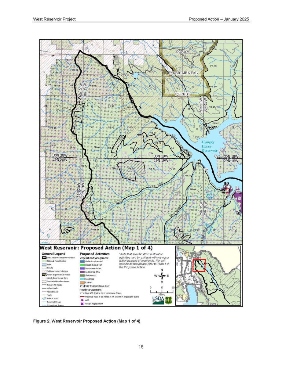
A preliminary proposed action, descriptions of the management activities, and project area map is available on the project page, as well as instructions on how to provide comments.
Members of the public should contact Paul Donnellon at [email protected] or (406) 387-3807 with questions.