Officials Issue Flood Watch, Avalanche Warning as Warm Temperatures and Precipitation Persist
Snow levels are expected to drop to the valley floor tonight with around a foot of new snow forecast at higher elevations through Wednesday
By Maggie Dresser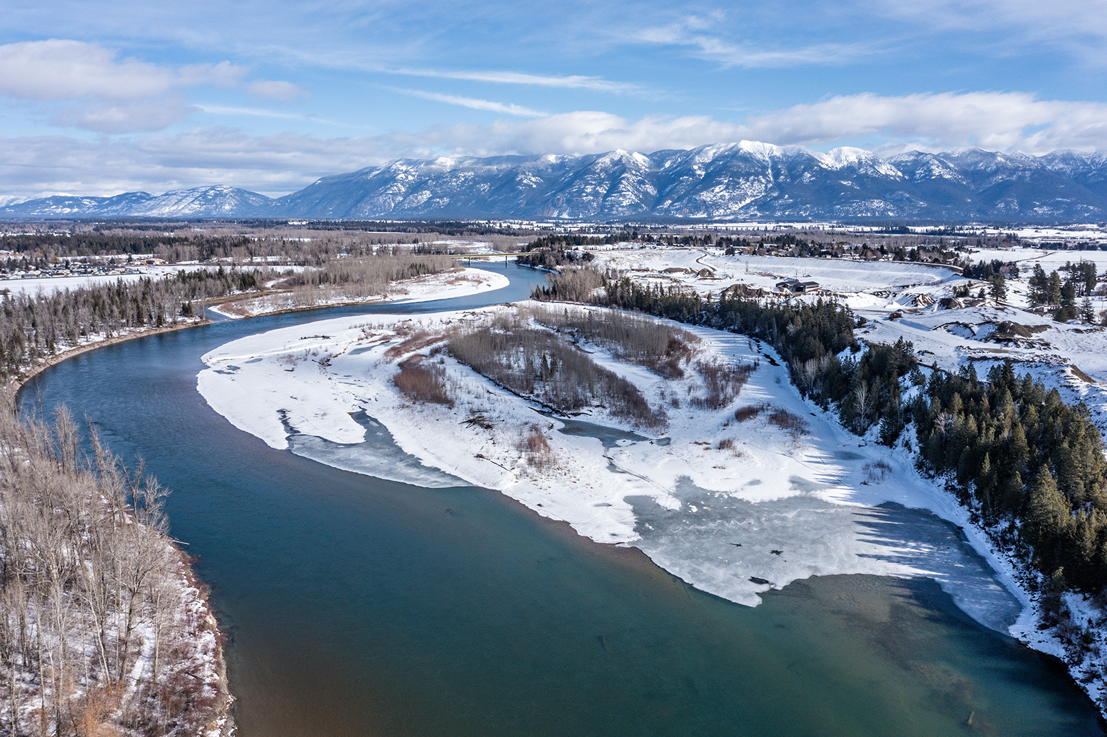
Amid a February heat wave following an atmospheric river that flushed through the Flathead Valley over the weekend, forecasters have issued an urban flood watch and a separate backcountry avalanche warning for northwest Montana.
Temperatures have remained above freezing at elevations below 5,000 feet, with valley temperatures on Sunday reaching 50 degrees in areas ranging from Condon to the south of the advisory area and Polebridge to the north, according to weather data.
The unseasonably warm temperatures combined with widespread rain have led National Weather Service officials to issue a flood watch in western Montana, with the potential to cause a release of ice jams along with snowmelt increasing the risk of lowland and urban flooding.
Storm totals brought 2 inches of snow water equivalent (SWE) to the Whitefish Range, 1.5 inches in the Swan Range and more than 2 inches in Glacier National Park. The Tunnel Ridge weather station in the Flathead Range recorded 8 inches of snow on Sunday night during the atmospheric river event while Whitefish Mountain Resort and Noisy Basin in the Swan Range received 6 inches, according to Monday’s Flathead Avalanche Center (FAC) advisory.
Following a brief respite from precipitation, temperatures will drop, and snow is forecast to return on Monday night continuing through Wednesday accompanied by winds gusting up to 40 mph. Snow showers above 3,000 feet will continue tomorrow with up to 7 inches of snow forecast on Marias Pass while high elevations could see around a foot of new snow.
As warm temperatures and precipitation continue, FAC forecasters advise against backcountry travel today at all elevations in the Whitefish, Apgar, Swan and Flathead mountain ranges along with portions of Glacier National Park.
According to a news release, triggered wet snow avalanches are likely below 6,000 feet while large natural and triggered avalanches are likely at high elevations. The added weight of the new snow could trigger the snowpack to fail on buried weak layers with avalanches potentially running long distances into low-angle terrain, valley floors and snowmobile trails.
“Conditions remain dangerous, and we advise you not to travel in avalanche terrain today,” FAC lead forecaster Mark Dundas wrote in Monday’s advisory. “There will be fresh snow to enjoy on low-angle slopes on Tuesday, warm temperatures with mostly clear skies, and good visibility for the remainder of the week. Plan on returning to the mountains on those days for a safer and more enjoyable experience.”
Starting Wednesday, high valley temperatures are forecast to hover around 45 degrees, dropping to lows of around 30 degrees through the weekend.
National Weather Service officials remind the public to clear gutters and downspouts to ensure proper drainage and reduce the risk of ice jams and lakes, and to safely remove snow from roofs. To prevent water accumulation and flooding, move snow away from home foundations to improve drainage and minimize seepage and clear window wells to prevent basement flooding.