Consulting Firm Unveils Foundational Maps for Land Use in Whitefish’s Growth Policy Update
The firm aiding the city’s state-mandated growth policy update presented two draft base maps to city councilors, residents and planning commission members throughout the week
By Lauren Frick
Whitefish residents, elected officials and planning commission members this week got their first glimpse at maps serving as building blocks for a land use plan that will guide where and what the city will develop over the next 20 years.
Representatives from czb, LLC, the consulting firm aiding the city’s state-mandated growth policy update, presented two draft base maps to city councilors, residents and planning commission members on several occasions throughout the week. The maps were the culmination of in-person and online community feedback over the last two months.
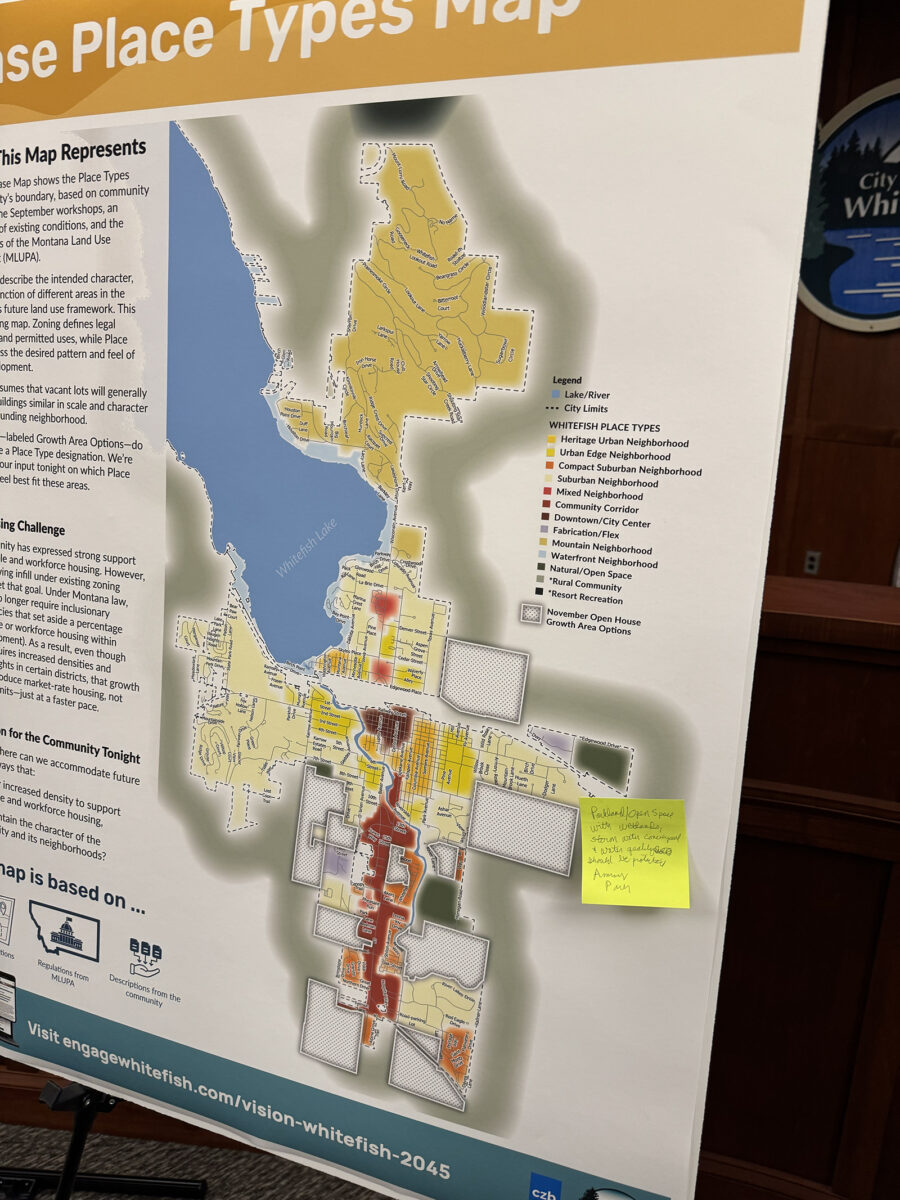
One map depicted Whitefish and its surrounding areas with a varying color-coded overlay — each color representing a different “place type” defined by the consulting firm. Although lacking the legal bite of a zoning map, the place types describe the intended “character, form and function” of an area, and express the desired pattern and feel of future development, according to the firm.
Consultants also presented a “street type” map, which was like the place type map, but featured a series of color-coordinated streets — each color corresponding to a certain usage level and balance between vehicle and pedestrian traffic.
While the maps will differ from the final land use map required in the city’s growth policy update, they served as a starting point to understanding the “character of the community” that will be essential to successfully convey in the final map, consultant Thomas Eddington said.
“The land use plan will include a land use map, so that you have an understanding of where recommendations are; where the different land uses, commercial, residential, etcetera,” Eddington said at Wednesday night’s planning commission meeting. “Of course, this builds upon some of the data that we are currently reviewing and analyzing.
“That will be a part of this plan, but we’re not there yet. As we think about preparing the land use plan, we’ve got, really, what we consider two foundational building blocks, and that is comprised of street types and place types.”
Land use is one of the several elements part of the multi-year process to update the city’s growth policy — a planning document intended to guide the city through growth and development over a 20-year-period.
Senate Bill 382, a 53-page law adopted in May 2023, requires a growth policy for any city of over 5,000 people in a county of over 70,000 people, likely enacting significant change in how developments are approved. A few months later, Whitefish began the process of updating its 2007 growth policy and is now looking to meet statutory requirements before the state’s deadline in May 2026.
Under SB 382, also known as the Montana Land Use Planning Act (MLUPA), local government is to emphasize public participation and comment during the creation or updating of its growth policy.
In the drafting of the base maps, the consulting firm held two in-person workshops centered on residents describing the “character” of Whitefish, Eddington said. The firm also offered a multi-week online survey in October, which attracted 150 participants, he said.
The two place types dominating Whitefish’s city limits were “Suburban Neighborhood” and “Mountain Neighborhood,” with much of the outer edges of the city being labeled suburban and all of the city north of Colorado Avenue deemed mountain.
Much of the land lining U.S. Highway 93 was labeled “Community Corridor,” which the firm defined as “auto-oriented commercial districts organized along a high-volume spine road, with deep front setbacks, large surface parking lots, and single-story buildings on individual pads or in strip formats.”
Patches of “Compact Suburban Neighborhood” blended along this community corridor, with the firm defining this place type as one that accommodates “smaller lots, townhomes, cottage courts, and other low-rise ‘missing-middle’ housing that gently increases density while keeping a suburban feel.”
The firm’s October survey found this corridor along state Highway 93 as an area to change most in the coming decades, with 90% of respondents saying it was one of the areas likely to change in the next 10-20 years, according to the firm.
Community members got another opportunity at a Tuesday night open house to provide additional feedback as the firm develops the land use map. Residents reviewed the maps and were asked their preferences between three place types options in relation to 10 locations in and outside of Whitefish city limits.
While “Mixed Neighborhood” was scarce on the draft base map, the place type saw more support in show of stickers from residents, largely in locations west of Highway 93 and south of downtown.
A Mixed Neighborhood place type features a “diverse blend of housing types,” such as single-family, duplexes, townhomes and small multi-family, in addition to neighborhood serving commercial uses such as coffee shops or restaurants, according to the firm.
While Whitefish’s growth policy will include separate land use and housing elements, the discussion among planning commission members Wednesday night when presented the two base maps always circled back to housing — specifically affordable housing.
The Montana Department of Commerce projects that the community will need about 2,100 new housing units by 2045, with roughly three-quarters needed for households earning less than $88,400. This means an estimated 1,600 of the 2,100 units will need to serve low- and middle-income households, Eddington told commission members Wednesday.
Simply allowing infill, the process of building new construction or redeveloping underused land within existing urban or suburban areas, under current zoning classifications won’t meet that goal, Eddington said.
A 2021 state law prohibits cities from requiring inclusionary zoning — policies that set aside a percentage of affordable or workforce housing within new development. While the state’s land use planning act requires increased densities and building heights in certain districts, that growth will likely produce market-rate housing, just at a faster pace, according to the firm.
“As we look forward, we recognize that there are some tough decisions ahead,” Eddington said. “Certainly, how do we as a community think about land use and housing to find opportunities to incentivize workforce housing?
“There’s got to be this, this balancing of scales between protecting character and getting the kind of housing that you want.”
Alan Tiefenbach, a long-range planner with the city who is leading the growth policy update, echoed Eddington, saying affordability, rather than quantity, will be the city’s greatest challenge.
“I know that we have been building the number of housing units every year that we’re supposed to build,” Tiefenbach said. “I understand that there’s a quantity issue for those of you that believe we need to be building more housing on the free market and all that. There is a quality issue. My opinion is that’s a lesser of an issue. The problem is the affordability, and the tools that we have have been taken away from us.”
As discussion over the housing element begins over the next month, a multi-faceted approach will be needed to achieve the city’s affordable housing goals, Tiefenbach said.
“We’re going to have to decide what we want to give up,” Tiefenbach said. “And there are some things that the city can give up; it just depends on if the city’s willing to do it.
“We have to have some stopgap measures in place.”