The Latest
— Cool weather helps fire crews, but extreme fire danger remains
— Stage II fire restrictions still in effect across most of Northwest Montana
— Tamarack Fire burning at 300 acres west of Kalispell
Cooler temperatures and light precipitation have aided firefighters as they tackle several incidents across the region, but residents are reminded that fire danger remains extreme and Stage II restrictions are still in place as more lightning is forecasted.
Campfires are still not allowed anywhere during the restrictions. The National Weather Service in Missoula expected lightning storms Monday evening and into Tuesday and for humidity to decrease each day. Dry cold fronts on Thursday and Sunday may enhance wind gusts.
Crews responded to 34 new fires since across the region since Friday.
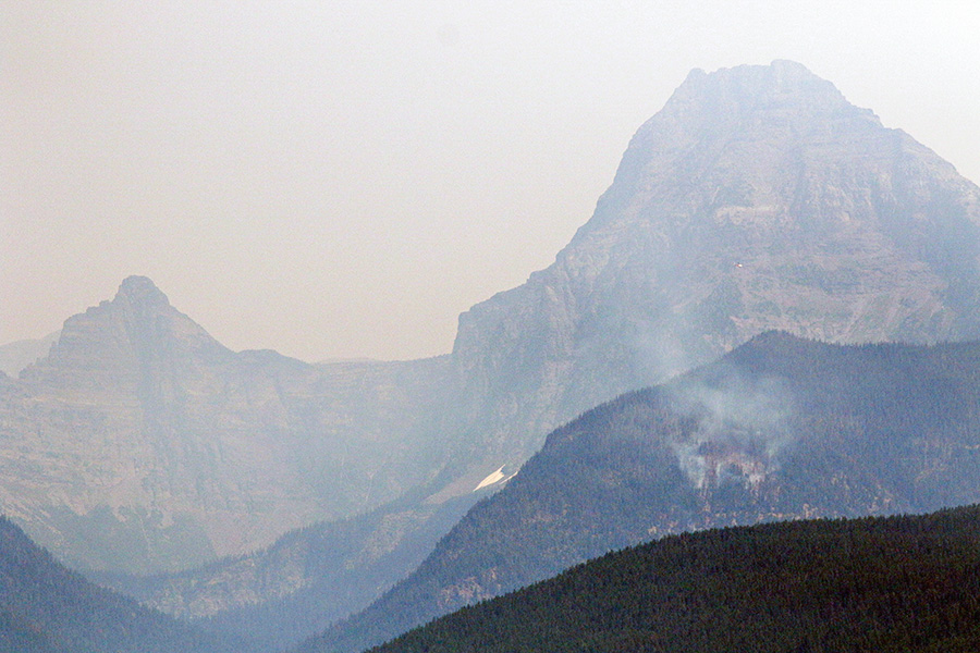
Glacier National Park has resumed issuing backcountry permits for designated sites. All front country campgrounds remain open. A spate of lightning sparked more than a dozen fires in the park, which has temporarily closed certain trails.
As of Aug. 14, trail closures remain in effect for the Howe Ridge Trail, Camas Trail, Trout Lake Trail, the Gunsight Pass Trail from Lake McDonald to Gunsight Pass (including all secondary trails such as the Snyder Lake Trail), and the Lincoln Lake Trail.
Visit the park’s website for updated closure information.
Sperry Chalet remains closed, and the complex isn’t necessarily threatened but the Sprague Fire, burning at about 35 acres, has resulted in the closure of the main trail accessing the chalet.
Most areas of the park are open, including all areas of the North Fork, Apgar Village, the Going-to-the-Sun Road, Granite Park Chalet, Two Medicine, St. Mary, Many Glacier and Goat Haunt. Check the park website for updated trail and road information at http://bit.ly/2uAE96d.
The Gibralter Fire near Eureka has burned 1,938 acres and is about 6 percent contained, as cooler temperatures and higher humidity have helped crews corral the blaze. The fire is contained near the intersection of Foothills Road and Sherman Creek. On Monday afternoon, evacuees were being allowed back into their homes. Grave Creek Road and the Ten Lakes recreation area are still closed.
There is a public meeting about the fire on Aug. 14 at 6 p.m. at Lincoln County High School in Eureka.
The Tamarack Fire, which started Aug. 12 due to lightning from the previous day, is burning at 300 acres and is located west of Kalispell, about nine miles northeast of Happy’s Inn. It grew from 10 acres to 300 in 24 hours, and a Type II team has taken over command as of Aug. 14.
The Blue Bay Fire on the east side of Flathead Lake has burned 51 acres, according to Confederated Salish & Kootenai Tribes Division of Fire Spokesperson CT Camel. The fire is 10 percent contained as of Aug. 14 although it continues to burn in “tough” terrain and Camel said firefighters are having a hard time keeping the line. A public meeting is being held on Monday night at 7 p.m. at the Blue Bay Campground.
The Cyclone Lake Fire, located in the Coal Creek State Forest in the North Fork area, has burned 36 acres and was caused by lightning. There are no evacuations in place and no structures threatened. The public is asked to avoid Forest Road #909 from the junction with Forest Road #319 to the Cyclone Lookout Trailhead Junction.
The Monahan Fire, which started July 16 from a lightning strike, continues to burn at 1,895 acres between Monahan Mountain on the Lolo National Forest side and the Little Apex Mountain on the Flathead National Forest side. The fire is being managed and allowed to burn. Trails closed include: #143, #277, #265, #142, #278, #140, #144, and #146.
Smoke continues to impact the Flathead Valley this week. You can check out the air quality for the valley and around the state by visiting the Flathead City-County Health Department website.