River Road East Fire Near Paradise Has Destroyed Structures, Sheriff Says
The remnants of Hurricane Hilary are expected to bring rain to some regional fires
By Mike Kordenbrock
River Road East
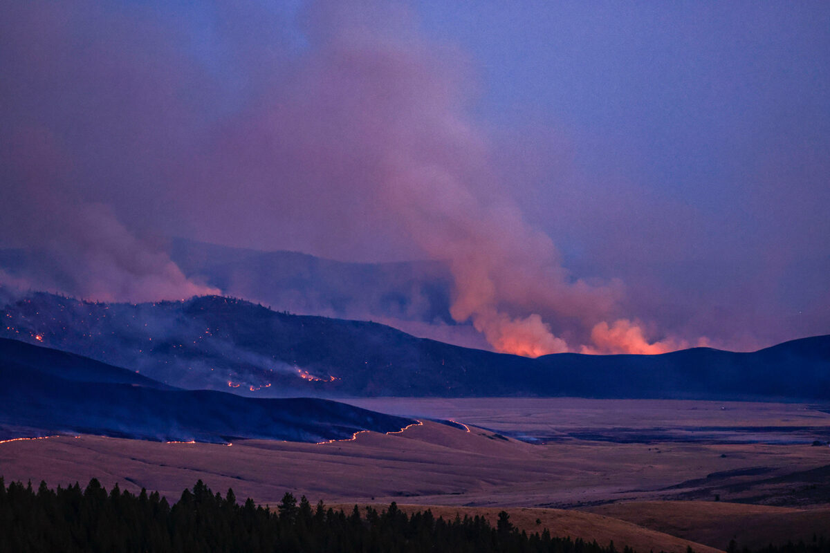
Burning near the Sanders County community of Paradise about six miles east of the community of Plains, the River Road East Fire as of Monday morning was estimated to be 16,790 acres in size and zero percent contained. An infrared flight heading into Monday mapped an increase of 3,376 acres in the fire’s size. A total of 370 firefighting personnel have been assigned to the incident. The cause of the fire remained under investigation Sunday.
Structures have burned down, Sanders County Sheriff Shawn Fielders told residents gathered Sunday afternoon for a community meeting in the Plains High School gym. Fielders indicated the structure losses were in the McLaughlin Creek area, which he said was still active and “a nightmare.”
“It breaks my heart that I can’t let you up there to see your place,” the sheriff said.
Crews dispatched to the area had only made it halfway up as of the Sunday afternoon meeting, and were having to cut their way through fallen trees and push rocks off the road, and in some cases cut their way back on the return trip due to additional fallen trees.
“I’ve been up there once, there are flares all over the place and everything’s still smoldering,” Fielders said.
An operation section chief with the incident management team on the fire said Sunday afternoon that crews were in the McLaughlin Creek area, including hotshots, working in dangerous conditions to protect structures that had survived the fire’s initial pass through, which had left some areas unburned.
The Sheriff’s Office is asking people with residences off McLaughlin Creek Road in Paradise or one of the roads that come off it to contact Sanders County Detective Phillips at 406-827-3484 extension 3, and leave a message with their name or names, phone number and address. Fielders said they were collecting information on addresses to verify losses before contacting owners, and that as soon as people are able to get to their properties safely they would be allowed to access them.
“There are structures that have burned down,” Fielders said. “I can tell you that right now. I’m not going to lead you on. There’s quite a bit of damage up there.”
Bill Naegli, the emergency manager for Sanders County, said at the meeting that the fire on Friday had brought out a response from every fire department in the county, and called the fire behavior “phenomenal.”
“Visualize your football field. That’s one acre. This fire did 12,000 acres in less than 12 hours,” Naegli said.
Fire activity on Sunday was moderate, and crews worked to secure control lines on the north edge of the eastern side of the fire in an effort to keep up with the fire along River Road East. Aircraft were also able to conduct additional retardant drops to protect Pat’s Knob Lookout and communications site. Crews on the western side of the fire continued to work on control lines around structures in the Paradise area, and worked to the north building fire control lines to keep the fire out of the Highway 200 corridor, according to a Monday morning fire update.
As of Sunday morning, an area from Paradise going east to the reservation boundary off of Highway 200 had been placed on pre-evacuation status, according to the Sanders County Sheriff’s Office.
Firefighting personnel also worked on Sunday to get ahead of the fire in Henry’s Creek and Camas Prairie, including by scouting out access routes for locations to build indirect and direct control lines. On the southwest side of the fire, crews remained in place to monitor fire movement in rocky terrain west of the junction of highways 135 and 200.
On Monday, crews planned to continue securing and mopping up control lines to protect structures in the community of Paradise and the Highway 200 corridor, as well as Pat’s Knob Lookout. Crews were also planning to work on control lines north and south of the river. Forecasts showed a likelihood of rain Monday morning and rain showers Monday afternoon, with temperatures between 68 and 78 degrees and relative humidity levels between 58% and 68%. The moisture and cooler temperatures are expected to moderate fire behavior. Winds on Monday are expected to be from the east and range between 5 miles per hour and 15 miles per hour.

East Fork Fire
As of Monday morning, the lightning-caused East Fork Fire burning about 12 miles south of Trego was expected to receive between half an inch and an inch of rain over the next day-and-a-half, with some heavy downpours expected.
The incident management team on the fire characterized the weather system as a “season-slowing,” but not “season-ending” event. Drier conditions are expected to return later this week. The expected rain is fueled by the remnants of Hurricane Hilary, which battered southern California and other parts of the southwest over the weekend. Some areas hit by the hurricane saw more than a half year’s worth of rain, including in Palm Springs, where more than 3 inches had fallen by Sunday night, according to the Associated Press.
After an evacuation order related to the fire was issued on Friday for all properties north of mile marker 146 on Highway 93 to mile marker 157.9, that evacuation order was downgraded to a pre-evacuation warning at 2 p.m. on Sunday by the Flathead County Sheriff’s Office. The original evacuation order had also included residents of Good Creek Road, and those who access Good Creek going west to the Lincoln County line. Pre-evacuation warnings related to the fire that were issued on Thursday, Aug. 17, remained in effect as of Sunday afternoon. Similarly, evacuation warning notices issued by the Lincoln County Sheriff’s Office on Aug. 18 for residents in the Stryker area of Lincoln County remained in effect Sunday afternoon, according to the Lincoln County Emergency Management Agency.
The fire is estimated to be threatening 200 structures, and none had been reported destroyed by Sunday. An estimated 5 percent of the 4,614-acre fire is considered contained, and 556 firefighting personnel have been assigned to it.
Firefighting crews on Sunday reported progress on the north side of the fire, and focused on areas with significant heat, and on handling spot fires, according to a Monday morning fire update. Aerial resources worked on Sunday to reduce fire spread into the Marin Creek area, including with super scooper planes and helicopter bucket drops.
Firefighting crews on Monday planned to look for opportunities to move closer to the fire front and build fire lines, and to extinguish hot spots. Aerial resources will be used as weather permits. A public meeting is scheduled for 7:30 p.m. Tuesday, Aug. 22, at the Olney-Bissell School.
A closure order remained in effect Monday for roads in the East Fork Fire area.
The East Fork Fire is believed to have been caused by lightning on the afternoon of July 30. Burning primarily in timber, the fire originated in the Fortine Ranger District of the Kootenai National Forest and has since crossed over into the Tally Ranger District of the Flathead National Forest.

Ridge, Doris Point and Tin Soldier Complex Fires
Steady rain expected to fall over the area of the Ridge Fire from Monday afternoon through the night is expected to produce moderate fire activity in the near future, but firefighting personnel are anticipating a return to normal late-August temperatures later this week.
The fire, burning in an area about six miles east of the community of Hungry Horse, is an estimated 3,651 acres in size, with 39 percent of its perimeter considered contained. Most of the uncontained perimeter on the fire is on its eastern section.
In an update shared on the fire’s InciWeb page late Monday morning, the incident management team working the fire shared that on Sunday crews on the northern, western and southeastern areas of the fire continued mop up work, and that a couple of spot fires on the northeastern edge of the fire were contained by firefighters. The fire grew an estimated 16 acres on Sunday.
For Monday, crews planned to continue mopping up and putting in control lines “where appropriate,” in order to prevent the fire from spreading to the north and east. Aviation resources will be used Monday as weather and winds permit.
Rain is also expected for several other nearby fires, including the Doris Point Fire (1,534 acres, zero percent contained) about eight miles southeast of Hungry Horse, and the Tin Soldier Complex (7,697 acres, zero percent contained) about 17 miles east of Swan Lake. All three fires were ignited by lightning on the afternoon of July 30. Forecasts show rain diminishing by Tuesday morning, but there are expectations for some showers through Tuesday evening due to additional moisture in the area.
The Tin Soldier Complex is threatening an estimated 101 structures, while the Doris and Ridge fires are threatening one structure each. As of Monday morning no structure losses had been reported from those fires. Acreage on the Tin Soldier Complex from Sunday to Monday increased an estimated 478 acres, while the Doris Point Fire saw an estimated acreage increase of 432 acres from Sunday to Monday.
Firefighting personnel on the Ridge and Doris Point fires should see 70 to 75 degree temperatures at lower elevations and 62 to 67 degree temperatures on mid-slopes and ridges on Monday. Relative humidity is expected to range between 46 and 51%, with winds to the east between 5 mph and 10 mph, and guests reaching 18 mph on the ridgetop.
Temperatures will be slightly cooler for firefighters on the Tin Soldier Complex, where lower elevations should see between 68- and 73-degree temperatures, and 62- to 67-degree temperatures from mid-slopes to ridges. Minimum relative humidity will be between 46% and 51%, with winds to the east going between 5 miles per hour and 10 miles per hour, with gusts around 18 miles per hour on the ridgetop.
A pre-evacuation notice from the Flathead County Sheriff’s Office, initially announced on Aug. 9, remained in place Monday morning for the east side of Spotted Bear Road to West Glacier, due to the Ridge and Doris fires. An evacuation order from the Flathead County Sheriff’s Office for the Heinrude community remained in place Monday morning due to the Tin Soldier Complex. Closures remained in place Monday for the Hungry Horse Reservoir, including its east and west side roads.
Niarada and Mill Pocket Fires
The Niarada Fire about 12 miles west of the town of Elmo and the Mill Pocket Fire about three miles west of Highway 28 were at or near complete containment as of Monday morning.
Crews continued to make progress on the fires over the weekend, which encompass an estimated area of more than 22,000 acres. The fires have damaged four structures.
Heading into the weekend, the Niarada Fire was 85% contained, and the Mill Pocket fire was 90% contained. As of Monday, firefighters reported the Niarada fire to be 95% contained, and the Mill Pocket fire to be 100% contained. The Lake County Sherff’s Office has lifted all pre-evacuation warnings related to the fires, and reisidents may bring livestock back home.
A fire update Monday from the incident management team shared that control lines have been tested through high wind and extreme heat, and crews will now work on repairing and rehabbing areas where possible in order to return things to as natural of a state as possible.
Showers and thunderstorms over the fire areas are expected Monday and Tuesday, with calm winds and precipitation amounts expected to range from a quarter to half an inch on Monday and a tenth of an inch on Tuesday.