Season-Slowing Weather Forecast as Regional Fires See Limited Weekend Growth
Midweek rain showers will further mitigate fire behavior, but long-term forecasts call for a hot and dry fall
By Micah Drew
The major wildfires in northwest Montana collectively saw minimal growth over the weekend, as crews utilized the tendrils of Hurricane Hilary to make progress on all blazes and allowing law enforcement agencies to roll back or downgrade some evacuation warnings.
Hot, dry and windy conditions in the early part of this week are expected to increase fire behavior, but an approaching storm cell and cold front are forecast to reach the valley late Tuesday evening. The storm could bring up to .75 inches of rain across the region through Thursday, providing “another season slowing opportunity,” said Danny Lemer, operations section chief with the Norther Rockies Interagency Management Team 6 assigned to the East Fork Fire burning near Trego.
The 5,000-acre fire is currently 15% contained with more than 600 personnel assigned to the incident, primarily working to keep the blaze from spreading closer to U.S. Highway 93.
Lemer said the fuel in the area — primarily spruce and subalpine fir — is a “firefighter’s worst nightmare” due to a thick, dense canopy that makes it hard for crews to build direct fire lines and increases the spotting potential. According to Lemer, the fire’s early rapid growth was due to a number of spot fires that ignited when embers from burning tree crowns got caught in the wind and blew ahead of the fire’s active line. Spot fires remain the biggest concern for the East Fork Fire, especially on Tuesday as winds preceding the storm move in, but the resulting cooler weather later in the week will aid crews as they continue building a continuous fire line along the northern edge.
Fire Behavior Analyst Eric Trimble said there is a low risk of significant fire spread on Monday, allowing crews to execute planned burnout operations that include using drones equipped with plastic sphere dispensers — ping pong balls injected with two chemical agents that react and ignite on the ground. The burning operation will help crews establish direct line along the fire’s active edge where it’s been difficult to get firefighters on the ground. Visible smoke is expected from burnout operations as well as internal fire growth as the blaze consumes the remaining fuel.
The region’s other major active fire, the River Road East Fire burning across 17,115 acres near the community of Paradise, located about six miles east of Plains, also saw minimal growth over the weekend, after reportedly destroying 55 structures since its ignition on Aug. 18.
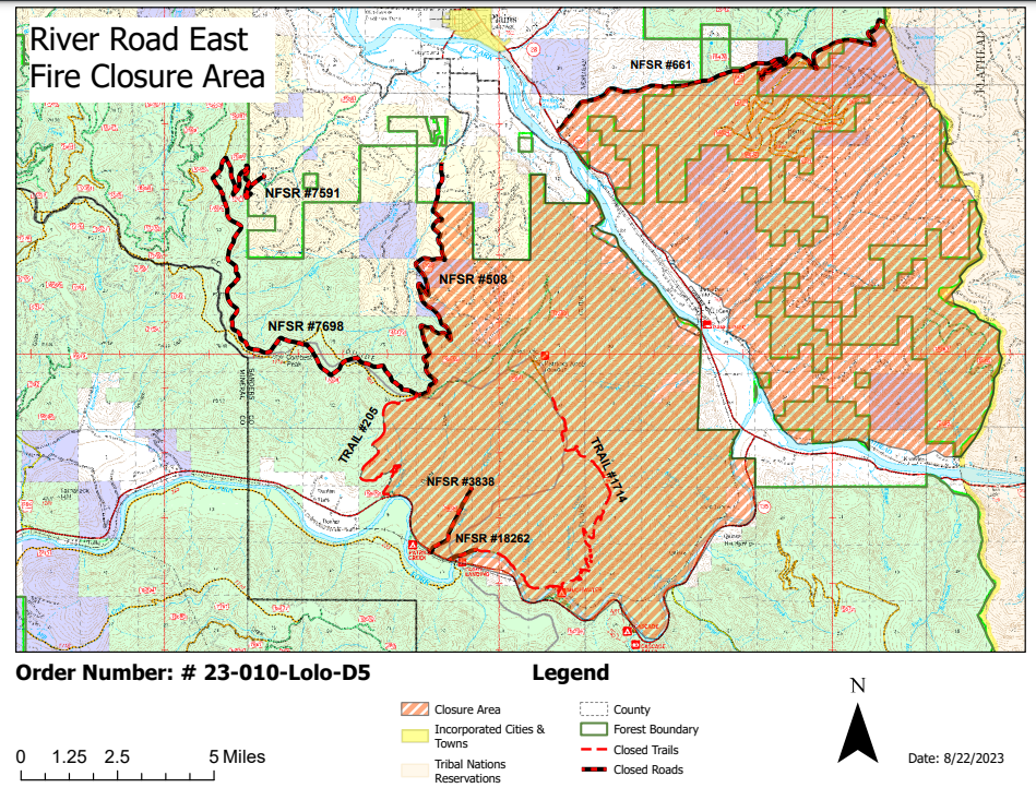
Despite the limited growth, officials with Lolo National Forest on Aug. 27 issued recreational closures in the region. All public access is closed on U.S. Forest Service (USFS) land north of Montana Highway 200 and south of Henry Creek Road #661 west to the Flathead Reservation Boundary. In addition, all USFS land north of Montana Highway 135 to the junction of Donlon Trail #205 and Highway 135. The closure includes the Ferry Landing Day Use Area, Muchwater Dispersed Campground and Cascade Landing, and will remain in place until the end of October, unless rescinded.
On the northwest side of the fire, crews will be conducting limited firing operations to secure control lines and remove low-lying vegetation ahead of the fire’s active edge. Smoke is expected to be visible from the Highway 200 corridor and from the community of Plains.
While the incoming cooler weather will aid firefighters across the region, long-term trends for the area continue to worsen. Bryan Anderson, a fire behavior analyst with the Northern Rockies Complex Incident Management Team assigned to the River Road East Fire said last week that September is forecast to be hotter and dryer than average and could extend the wildfire season later than normal.
Major Wildfire Incidents
East Fork Fire
Ridge Fire
Tin Soldier Complex
Doris Point Fire
Big Knife
River Road East
East Fork Fire
Location: 12 miles south of Trego
Size: 5,106
Containment: 15%
Personnel: 611
Evacuation Warnings/Orders and Road Closures:
Operational Updates: Firefighters will continue burnout operations in strategic locations using drones equipped with plastic sphere dispensers —ping-pong balls filled with two chemical agents that ignite once on the ground. Crews will continue working to put direct fire line along the northern edge of the fire and prevent regression towards Highway 93.
Ridge Fire
Location: 6 miles southeast of Hungry Horse
Size: 3,665 acres
Containment: 76%
Personnel: 407
Evacuation Warnings/Orders and Road Closures: All access to Hungry Horse Reservoir remains closed to the public. The Forest Closure Order that includes the Heinrude Community remains in effect.
Operational Updates: Crews are working to clean up and repair areas impacted by earlier suppression efforts, including budling water bars on handlines to reduce likelihood of future erosion.
Tin Soldier Complex
Location: 17 miles east of Swan Lake
Size: 8,165
Containment: 81%
Personnel: 79
Evacuation Warnings/Orders and Road Closures: All access to Hungry Horse Reservoir remains closed to the public. The Forest Closure Order that includes the Heinrude Community remains in effect.
Operational Updates: Mechanical thinning projects will create fuel breaks north of Spotted Bear. Structure protection remains itn eh Spotted Bear area, but extra equipment will be removed from Heinrude Community today.
Doris Point
Location: Eight miles south of Hungry Horse
Size: 1,597
Containment: 68%
Personnel: 26
Evacuation Warnings/Orders and Road Closures: All access to Hungry Horse Reservoir remains closed to the public. The Forest Closure Order that includes the Heinrude Community remains in effect.
Operational Updates: Structure protection has been removed north of the Lost Johnny Area, but remains in place at Lost Johnny Point and the boat launch. Increased fire behavior to the southwest is not anticipated to impact structures of developed areas.
Big Knife
Location: 5 miles east of Arlee
Size: 7,276
Containment: 17%
Personnel: 112
Evacuation Warnings/Orders and Road Closures: Several areas near the base of the mountains west of the fire remain in PRE-EVACUATION status and are highlighted in yellow on the map. The Tribal Primitive Area, Belmore Slough and Burnt Cabin Roads remain closed.
Operational Updates: Crews are continuing suppression repair work, and are removing structural protection from some areas. The current incident management team will transition command to a local unit on Wednesday. The fire is currently 1.25 miles north of the Rattlesnake Wilderness Boundary, but has shown no significant growth towards the Lolo National Forest in the last week.
River Road East
Location: 6 miles southeast of Plains
Size: 17,115
Containment: 14%
Personnel: 711
Evacuation Warnings/Orders and Road Closures: On Aug. 27, the Lolo National Forest issued closures for all Forest Service land south of Henry Creek Road #661 west to the Flathead Reservation Boundary. In addition, all FS land north of MT Highway #135 to the junction of Donlon Trail #205 and Highway #135. See map for more details.
Operational Updates: Crews conducted limited firing operations on Pat’s Knob over the weekend to aid in securing the control line ahead of the fire’s active edge. Firefighters continue to work on creating a direct control line on the eastern edge of the fire, along the Lolo National Forest and CSKT Boundary. The Highway 200 corridor is being continuously patrolled with ongoing mop up operations.