Cold Front Temporarily Abates Wildfires as Crews Look Ahead to Hot, Dry Conditions
Fire managers reported progress as favorable weather conditions cool northwest Montana, but increased fire activity could return in the coming days
By Denali Sagner
In the wake of cooling temperatures and slight rainfall, crews across northwest Montana have made headway on containing a number of wildland fires burning in the area. The favorable weather conditions dampened fire activity in the Flathead National Forest, where crews are working to extinguish the Ridge Fire and Tin Solider Complex, as well as on the Flathead Indian Reservation, where the Niarada, Mill Pocket and Big Knife fires have consumed more than 27,452 acres.
“Wetter and cooler and weather have slowed the growth for the last couple of days, which is definitely welcome. They’re definitely taking advantage of that weather to get ahead,” Flathead National Forest Public Affairs Specialist Kira Powell said of wildland fire crews.
Recent weather events brought .1 inches of rain to the Tin Soldier Complex, located 17 miles east of Swan Lake, and .07 inches to the Colt Fire, located northwest of Seeley Lake.
Powell said that even minimal rain is a positive development, as crews in northwest Montana battle fires in some of the driest climate conditions to date. The U.S. Secretary of Agriculture on July 31 designated Flathead and Lincoln counties as primary natural disaster areas due to extreme drought conditions.
Currently, 90.89% of Flathead County residents are living in severe drought conditions, according to the U.S. Drought Monitor, as well as 100% of Lincoln County residents, 88.07% of Lake County residents and 75.64% of Glacier County residents.
“We had good spring snow, but it melted so quickly because of that hot May,” Powell said. “Even .07 inches of rain helps.”
However, Powell and fire managers warned that recent rainfall, while advantageous for crews, certainly does not mark the end of fire season in northwest Montana. Hot and dry weather is expected to return in the coming days, once again creating prime conditions for increased fire activity.
“This is in no way a season-ending event. The fire is still burning and the weather is forecasted to switch back to summer next week,” Powell said.
There will be a public meeting regarding the Ridge Fire with members from the California Interagency Incident Management Team 4 at 7 p.m. tonight at the Glacier Bible Camp, 400 5th St. W. in Hungry Horse. The meeting will also be streamed on YouTube and Facebook.
There will also be a public meeting tonight at 6 p.m. the Arlee Community Center to discuss the Niarada, Mill Pocket and Big Knife Fires. The meeting will be broadcast live on the CSKT Division of Fire Facebook page.
Please note that the following reflects the latest information received at the time of publication. To see the latest updates for all major wildfires visit inciweb.nwcg.gov.
Major Wildfire Incidents
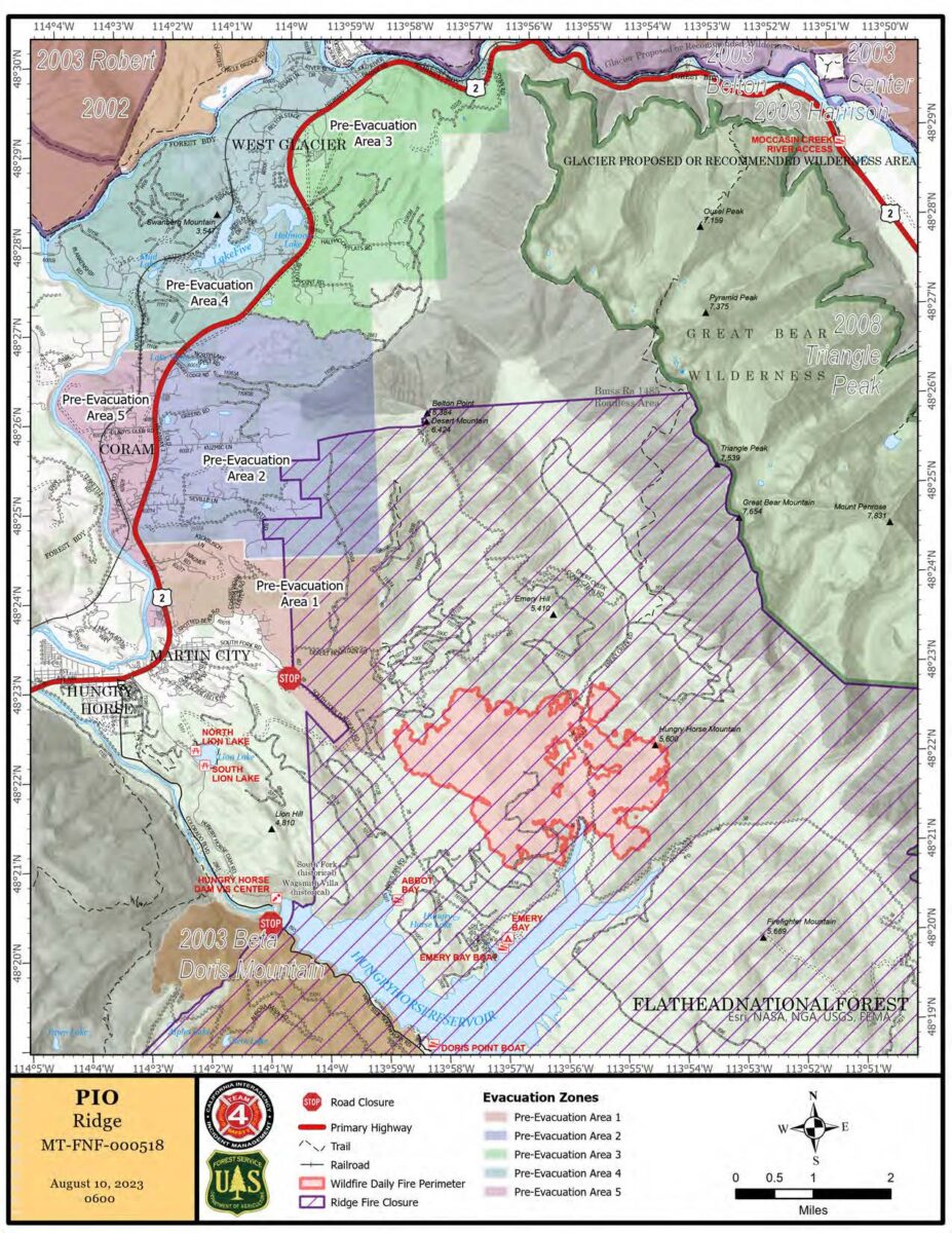
Ridge Fire
Tin Soldier Complex
Mill Pocket / Niarada Fire
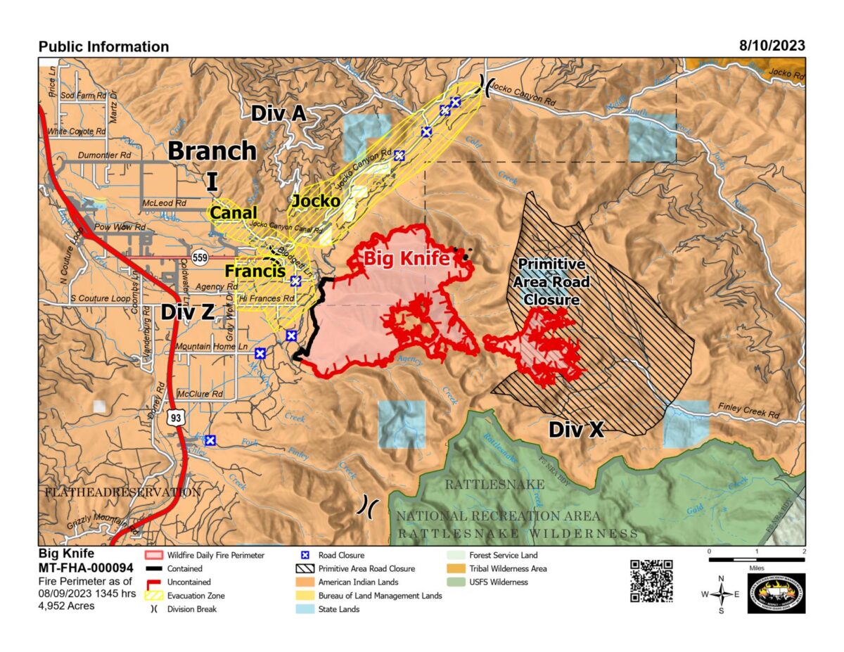
Big Knife
Colt Fire
Sidney Fire
Ridge Fire
Location: 6 miles southeast of Hungry Horse
Size: 2,940 acres
Containment: 0%
Personnel: 277
Evacuation Warnings/Orders and Road Closures: The Hungry Horse Reservoir is closed to all public access, including both the east and west side roads. The closure includes all roads, trails, and recreation sites in the area. The waters of Hungry Horse Reservoir and all islands are closed from Hungry Horse Dam to the Spotted Bear District boundary.
The following road closures are in effect:
- FS Road #38 (East Side Road #38) is closed to all public traffic east of the junction of FS Road #497 (Desert Mountain Road) and East Side Road #38.
- FS Road #895 (West Side South Fork Road #895) is closed to all public traffic starting at mile 15, near the Lid Creek Campground.
- West Side South Fork Road #895 from the Hungry Horse Dam Visitor Center to the existing closure at mile 15, near the Lid Creek Campground. Pre-evacuation notice in effect for private property along SF Abbot Creek on the west side of the fire.
The Flathead County Sheriff’s Office has placed residents on the east side of Highway 2, north of Spotted Bear Road to West Glacier, under a pre-evacuation warning due to the growing threat of the Ridge Fire.
Operational Updates: Due to a cold front and wetting rain yesterday, crews were able to improve perimeter lines on the south and east sides of the fire while holding its size at 2,940 acres. There was minimal fire activity last night. Firefighters will continue to improve perimeter lines and will attack the fire directly on a portion along FS Road #38 today. Weather permitting, aircraft will support ground resources with aerial drops in inaccessible terrain on the eastern flank of the fire. While crews experienced rain yesterday, conditions are expected to be hotter and drier in the coming days, possibly accelerating fire behavior.
Additional Information: There will be a community meeting with members from the California Interagency Incident Management Team 4 at 7 p.m. tonight at the Glacier Bible Camp, 400 5th St. W. in Hungry Horse. The meeting will also be streamed on YouTube and Facebook.
Tin Soldier Complex
Location: 17 miles east of Swan Lake
Size: 2,632 acres
Containment: 0%
Personnel: 70
Evacuation Warnings/Orders and Road Closures: The Hungry Horse Reservoir is closed to all public access, including both the east and west side roads. The closure includes all roads, trails, and recreation sites in the area. The waters of Hungry Horse Reservoir and all islands are closed from Hungry Horse Dam to the Spotted Bear District boundary. An area closure is also in effect for the front country of the Spotted Bear district, as well the Gorge Creek drainage within the Bob Marshall Wilderness area, including Feather, Inspiration, Gorge, Canyon Trickle, and Stadium Creeks.
The Flathead County Sheriff has ordered an evacuation for the Heinrude community.
A temporary flight restriction is in place for air space over the Tin Soldier Complex, including the Spotted Bear and Meadow Creek Airstrips, to provide a safe environment for firefighting aircraft operating in the area.
Operational Updates: Structural protection efforts will continue today for the Spotted Bear Ranch, Diamond R Ranch, Spotted Bear Ranger Station compound and Heinrude community. A crew will resume work to wrap the Spotted Bear Lookout. Mechanical equipment crews will continue to establish a fuel break to the south and re-establish fuel breaks to the north end. Fire personnel will continue to lay hose line and sprinklers around structures within the Heinrude community.
A cold front moved through the area yesterday, bringing 0.1 inches of rain and strong winds, and cool, breezy weather is expected today. A warming and drying trend is anticipated to begin on Friday and continue through the weekend.

Mill Pocket / Niarada Fire
Location: 15 / 12 miles west of Elmo
Size: 2,135 acres / 20,365 acres
Containment: 51% / 39%
Personnel: 367
Evacuation Warnings/Orders and Road Closures: The Lake County Sheriff’s Office is downgrading those in EVACUATION status near the Niarada Fire in Lake County to a PRE-EVACUATION WARNING. This area includes Alexander Road, Early Dawn Road, Spring Lane Road, Walking Horse Lane, Windward Heights Road, Wildhorse View, Buffalo Bridge Road, Saddle Drive, Island Butte Lane, Bridle Path, Ten Deuce Way, Cliffview Drive, and Ricketts Road.
A PRE-EVACUATION WARNING means that residents may return to their homes. However, as there is still a potential threat from the Niarada Fire, residents are encouraged to not bring back evacuated livestock until the area is downgraded to READY status.
The remainder of the town of Elmo is in READY status.
Drivers are encouraged to use extreme caution when driving on Highway 28. Though authorities have removed a modified speed limit, firefighters and equipment are still working in the area.
A temporary flight restriction (TFR) is in effect around the Niarada/Mill Pocket and Big Knife fire areas. Citizens are barred from flying unmanned aircraft (drones) near the fire areas, as it is hazardous for pilots, and firefighters on the ground who rely on aircraft support.
Operational Updates: Light rain on Wednesday wet small and medium fuels, allowing crews to build more direct handline than earlier in the week, however the precipitation did not penetrate heavy timber canopies. Firefighters are continuing to “mop up” along Cromwell Creek Road, working inward from the fire’s edge, and assess pockets on unburned fuels west of that line to evaluate whether or not they pose concerns for containment. Heavy fuels and steep terrain continue to present challenges along the fire’s eastern and southeastern edges. Structural protection crews are continuing to work outside Elmo towards Big Arm.
Additional Information: Stage 2 fire restrictions are currently in place across the Flathead Indian Reservation. Citizens are barred from starting campfires, smoking outside of vehicles, operating combustible engines between 1 p.m. and 1 a.m., and operating vehicles off designated roads and trails.
There will be a public meeting tonight, Aug. 10, at 6 p.m. the Arlee Community Center to discuss the Niarada, Mill Pocket and Big Knife Fires. The meeting will also be broadcast live on the CSKT Division of Fire Facebook page.

Big Knife
Location: 5 miles east of Arlee
Size: 4,952 acres
Containment: 5%
Personnel: 375
Evacuation Warnings/Orders and Road Closures: The Lake County Sheriff’s Office has placed several areas near the base of the mountains west of the Big Knife Fire in PRE-EVACUATION status. In the Tribal Primitive Area, Belmore Slough and Burnt Cabin Roads are closed.
A temporary flight restriction (TFR) is in effect around the Niarada/Mill Pocket and Big Knife fire areas. Citizens are barred from flying unmanned aircraft (drones) near the fire areas, as it is hazardous for pilots, and firefighters on the ground who rely on aircraft support.
Operational Updates: A passing cold front and precipitation yesterday dampened fire behavior. Fire managers are evaluating long-term potential fire growth due to projected hot and dry weather conditions in the coming days. Crews are continuing to assess and implement point protection measures to protect infrastructure and cultural resources identified by Resource Advisors. Firefighters are mopping up the edge of a strategic firing operation conducted late last week to contain the fire north of Agency Creek. Aircraft are aiding firefighters as conditions allow, and fire managers are using an Unmanned Aircraft System (UAS) to perform reconnaissance and infrared (IR) detection flights in South Fork Jock Canyon and Agency Creek areas.
Additional Information: Stage 2 fire restrictions are currently in place across the Flathead Indian Reservation. Citizens are barred from starting campfires, smoking outside of vehicles, operating combustible engines between 1 p.m. and 1 a.m., and operating vehicles off designated roads and trails.
There will be a public meeting tonight, Aug. 10, at 6 p.m. the Arlee Community Center to discuss the Niarada, Mill Pocket and Big Knife Fires. The meeting will also be broadcast live on the CSKT Division of Fire Facebook page.
Colt Fire
Location: 15 miles northwest of Seeley Lake
Size: 7,202 acres
Containment: 45%
Personnel: 579
Evacuation Warnings/Orders and Road Closures: Numerous National Forest System (NFS) lands, roads, trails in the Swan Lake and Seeley Lake Ranger Districts of the Flathead National Forest and Lolo National Forest are closed to the public. See the map below for the specific closure areas.
All roads within the closure area boundary including but not limited to: NFSR #906, NFSR #646, NFSR #4356, NFSR #4354, NFSR #552, and NFSR #4349.
All trails within the closure area boundary including, but not limited to:
- Forest System Trail 34 (Jocko Trail) is closed from the Jocko Trailhead at Lindbergh Lake to the intersection of Forest System Trails 351 and 35.
- Forest System Trail 35 is closed from the intersection of Forest System Trail 34 to the Crystal Lake South Trailhead.
The temporary flight restriction (TFR) for the fire area (FDC 3/7867) has been extended from 8 a.m.-10 a.m. to a full 24-hour restriction in order to provide a safe environment for firefighting aircraft operating in the area.
Operational Updates: The Colt Fire received about 0.07 inches of rain yesterday evening, as well as winds gusting to up to 30 mph. The unmanned aerial system (UAS) successfully mapped out areas of heat along the fire’s northern perimeter yesterday, providing vital data to firefighters to pinpoint heat in the fire area that is too dangerous or difficult for crews to access from the ground. Crews are expected to need three more days to complete the handline from the south flank of the fire to Sunset Ridge, which will connect their handline with the existing line constructed by heavy equipment along the ridgeline. The UAS will be mapping out the southern edge of the fire today, as conditions permit. A drop in humidity and increase in temperatures is expected to bring an uptick in fire behavior in the coming days.
Sidney Fire
Location: 21 miles south of Browning
Size: 49 acres (information up to date as of Wed. Aug. 9)
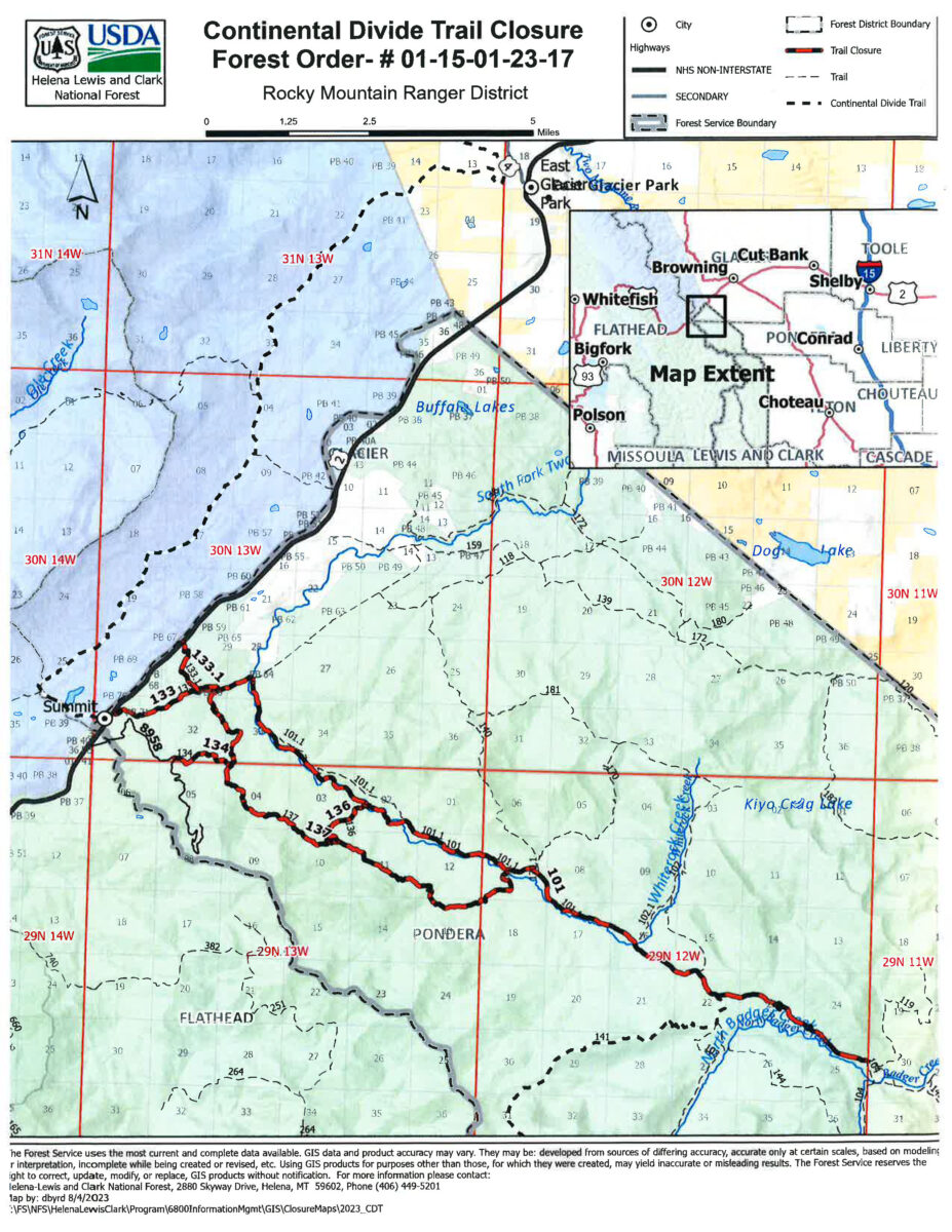
Evacuation Warnings/Orders and Road Closures: The following trails along the South Fork of the Two Medicine River and within the identified sections on the map (T29N, R12W, sections 7,8, 15, 16, 17, 18, 21, 22, 23, 24, 25) (T29N, R13W, sections 1, 2, 3, 4, 5,10,11,12,13) and (T30N, R13W, sections 28, 29, 31, 32, 33, 34) are closed due to the Sidney Fire:
- From the intersection of Trail 119 and Trail 101 to the junction of 101 and 133.
- Trails 133, from Summit Trailhead, and Trail 133.1, from Summit Campground, to where these 2 trails join Trail 101.